Skip to search
Skip to main content
Skip to first result
Search
You Searched For
Genre
Maps
Publication Place
New York :
New Search
Search Results
Creator:
Published / Created:
[between 1827? and 1850?]
Call Number:
21cea 1830
Container / Volume:
BRBL_00016
Image Count:
1
Resource Type:
Maps, Atlases & Globes
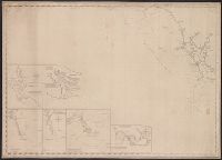
Description:
Insets: Cape Fear River, from its entrance to Smithville. Scale [ca. 1:60,000] -- Beaufort harbour. Scale [ca. 1:40,000] -- The bar & roads of Occracock [sic]. Scale [ca. 1:100,000] -- Cape Hatteras. Scale [ca. 1:110,000] -- Cape Lookout. Scale [ca. 1:275
Publisher:
E. & G.W. Blunt,
Subject (Geographic):
Atlantic Coast (N.C.)--Maps., Beaufort (N.C.)--Maps., Cape Fear River Estuary (N.C.)--Maps., Fear, Cape (N.C.)--Maps., Hatteras, Cape (N.C.)--Maps., Lookout, Cape (N.C.)--Maps., and North Carol
Subject (Name):
Hooker, William
Subject (Topic):
Coasts, Coasts--North Carolina--Outer Banks--Maps., Harbors, Harbors--North Carolina--Beaufort--Maps., Nautical charts, Nautical charts--No, and Nautical charts--North Carolina--Atlantic Coast.
Found in:
Beinecke Rare Book and Manuscript Library > [Coast chart from Cape Hatteras to Cape Fear, North Carolina [cartographic material] : with insets of Cape Hatteras, Ocracoke Bar and Roads, Cape Lookout, Beaufort Harbour, Cape Fear, and the Cape Fear River] / engraved & printed by W. Hooker.
Published / Created:
1940
Call Number:
30hd 1940I
Container / Volume:
BRBL_00038
Image Count:
1
Resource Type:
Maps, Atlases & Globes
Publisher:
C.S. Hammond & Co.,
Subject (Geographic):
Europe--Maps
Found in:
Beinecke Rare Book and Manuscript Library > [Europe-Western Battle Lines].
Published / Created:
c1915.
Call Number:
902 1915
Container / Volume:
BRBL_00665
Image Count:
1
Resource Type:
Maps, Atlases & Globes
Description:
"No. 1B" outside neat line upper right., Routes between larger cities noted in colored ink., and Shows steamship routes.
Publisher:
Richard Mayer,
Subject (Geographic):
Colombia--Maps
Found in:
Beinecke Rare Book and Manuscript Library > [Map of Colombia].
Published / Created:
[ca. 1905]
Call Number:
771 N49 1905R
Image Count:
1
Resource Type:
Maps, Atlases & Globes
Description:
Showings holdings of American Real Estate Co. with regard to sale of their 6% gold bonds.
Publisher:
August R. Ohman,
Subject (Geographic):
New York (N.Y.)--Maps--Early works to 1800
Subject (Name):
American Real Estate Company
Found in:
Beinecke Rare Book and Manuscript Library > [New York City real estate].
Published / Created:
1850
Call Number:
754gme 1850
Container / Volume:
BRBL_00419
Image Count:
1
Resource Type:
Maps, Atlases & Globes
Description:
Shows geographic area bounded by the Mississippi, Missouri, Ohio, Allegheny and Cumberland Rivers and the Great Lakes.
Publisher:
Sarony and Major, lith.,
Subject (Geographic):
Great Lakes (North America)--Maps
Found in:
Beinecke Rare Book and Manuscript Library > [Railroads of the Lake States, from Great Lakes to Ohio River]
Branch:v1.61.6 ,Deployed:2024-06-12T09:55:37-04:00