Skip to search
Skip to main content
Skip to first result
Search
You Searched For
Language
German
Publication Place
Weimar :
New Search
Search Results
Published / Created:
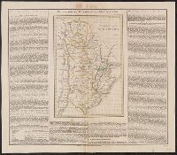
1823
Call Number:
94 1823
Container / Volume:
BRBL_00675
Image Count:
1
Resource Type:
Maps, Atlases & Globes
Publisher:
Geographische Institut,
Subject (Geographic):
Argentina--Maps
Found in:
Beinecke Rare Book and Manuscript Library > Vereinigte Provinzen von Süd America.
Published / Created:
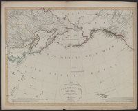
1804
Call Number:
21 1804
Container / Volume:
BRBL_00724
Image Count:
1
Resource Type:
Maps, Atlases & Globes
Publisher:
Im Verlag des Geograph. Instituts,
Subject (Geographic):
North Pacific Ocean--Maps
Found in:
Beinecke Rare Book and Manuscript Library > Der noerdliche Theil des grossen Welt Meeres ... / von C.G. Reichard.
Published / Created:
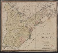
1800
Call Number:
755 1800C
Container / Volume:
BRBL_00437
Image Count:
1
Resource Type:
Maps, Atlases & Globes
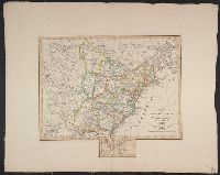
Description:
Colored map.
Publisher:
F.L. Güssefeld,
Subject (Geographic):
Canada--Maps--Early works to 1800 and East (U.S.)--Maps--Early works to 1800
Found in:
Beinecke Rare Book and Manuscript Library > Charte der XV Vereinigten Staaten von Nord-America Nach murdochischer Projection entworfen nach den neuesten astronomischen Ortsbestimmungen berichtiget und gezeichnet von F.L. Güssefeld.
Creator:
Published / Created:
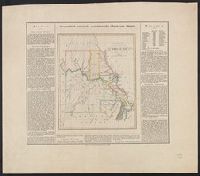
1826
Call Number:
816 1826
Container / Volume:
BRBL_00561
Image Count:
1
Resource Type:
Maps, Atlases & Globes
Alternative Title:
Geographisch-statistische und historische Charte von Missury.
Description:
Includes text., Relief shown by hachures., and Title in top margin: Geographisch-statistische und historische Charte von Missury.
Publisher:
im Verlage des geographischen Instituts,
Subject (Geographic):
Missouri--Maps
Found in:
Beinecke Rare Book and Manuscript Library > Missuri.
Creator:
Published / Created:
1814
Call Number:
88 M57 1814
Container / Volume:
BRBL_00647
Image Count:
1
Resource Type:
Maps, Atlases & Globes
Description:
"Schleuen, sc.", Includes "Profil des Canals oder Desague Real von Huehuetoca.", and Relief shown by hachures.
Publisher:
Verlage des Geograph Instituts,
Subject (Geographic):
Mexico Valley (Mexico)--Maps
Subject (Name):
Schleuen
Found in:
Beinecke Rare Book and Manuscript Library > Neue Charte des Thales von Mexico : und der benachbarten Gebirge / an Ort und Stette gezeichnet im J. 1804, von Don Louis Martin, ausgearbeitet und verbesfert im J. 1807 nach den trigonometrischen Vermesfungen von Don Joaquin Velasquez und den astronomisc
Published / Created:
1814
Call Number:
85 1814
Container / Volume:
BRBL_00638
Image Count:
1
Resource Type:
Maps, Atlases & Globes
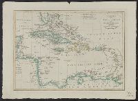
Description:
Borders are hand colored according to European possession., Includes three bar scales., Prime meridians: Ferro and London., and Relief shown by hachures.
Publisher:
Im Verlage des Geograph. Instituts,
Subject (Geographic):
West Indies--Maps
Subject (Name):
Geographisches Institut (Weimar, Thuringia, Germany)
Found in:
Beinecke Rare Book and Manuscript Library > Charte von West Indien oder den Antillischen Inseln.
Published / Created:
1824
Call Number:
853 1824
Container / Volume:
BRBL_00640
Image Count:
1
Resource Type:
Maps, Atlases & Globes
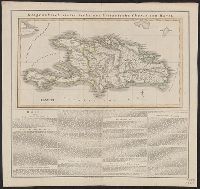
Description:
Text.
Publisher:
Geographische Institut,
Subject (Geographic):
Hispaniola--Maps--Early works to 1800
Found in:
Beinecke Rare Book and Manuscript Library > Geographisch-statistische und historische charte von Hayti.
Published / Created:
1814
Call Number:
853 1814
Container / Volume:
BRBL_00640
Image Count:
1
Resource Type:
Maps, Atlases & Globes
Publisher:
Geographische Institut,
Subject (Geographic):
Hispaniola--Maps
Found in:
Beinecke Rare Book and Manuscript Library > Neue Charte von S. Domingo ...
Published / Created:
1820
Call Number:
75 1820
Container / Volume:
BRBL_00397
Image Count:
1
Resource Type:
Maps, Atlases & Globes
Description:
A small addition has been pasted on to include Florida and the Bahamas.
Publisher:
Geograph. Instituts,
Subject (Geographic):
United States--Maps
Found in:
Beinecke Rare Book and Manuscript Library > Charte von den Vereinigten Staaten von Nord America mit Luisiana.
Published / Created:
1825
Call Number:
911 1825
Container / Volume:
BRBL_00669
Image Count:
1
Resource Type:
Maps, Atlases & Globes
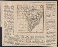
Description:
Border of Descriptive and Statistical text. and Insets: Trinidad; Ferando de Noronho
Publisher:
des Geographischen Institutes,
Subject (Geographic):
Brazil--Maps
Found in:
Beinecke Rare Book and Manuscript Library > Brasilien.
Branch:v1.64.0 ,Deployed:2024-09-11T10:25:34-04:00