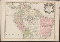
Tabula geographica Peruae, Brasiliae & Amazonum Regiones
Description:
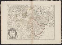
"Avec privil.", Appears in Cóvens and Mortier's Atlas nouveau; cf. Koeman, C. Atlantes Neerlandici, II C & M 4., Cross Collection no. 326., Mounted in linen., Ms. no. on verso: no. 108., Prime meridian: Ferro., and Relief shown pictorially.
Hand col. in outlines only. Sheet measures 58.2 x 79.8 cm., Includes five bar scales., Prime meridian: Ferro., Relief shown pictorially., and Watermark.
Publisher:
Chez l'Auteur ...,
Subject (Geographic):
Africa, Northeast--Maps--Early works to 1800 and Middle East--Maps--Early works to 1800
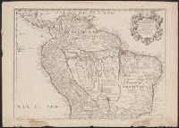
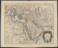
Appeared in de L'Isle's Atlas nouveau (after 1757)., Includes five bar scales., Prime meridian: Ferro., Relief shown pictorially., and With watermark. Sheet measures 54.8 x 65.7 cm.
Publisher:
Chez Iean Cóvens et Corneille Mortier,
Subject (Geographic):
Africa, Northeast--Maps--Early works to 1800 and Middle East--Maps--Early works to 1800
Atlas geographique et physique du royaume de la Nouvelle-Espagne, fonde sur des observations
Image Count:
1
Resource Type:
Maps, Atlases & Globes
Description:
At foot: Dessine par G. Grossman, termine par F. Friesen a Berlin 1807 et par A. Humboldt a Paris 1808 / Grave par Barriere - et l'Ecriture par L. Aubert pere and Longitude Occidentale de Paris
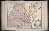
Fry, Joshua, 1700 (ca.)-1754 Haussard, Elisabeth. Jefferson, Peter, 1708-1757 Robert de Vaugondy, Gilles, 1688-1766 Robert de Vaugondy, Gilles, 1688-1766, creator
Published / Created:
1755
Call Number:
2003 Folio 85
Image Count:
1
Description:
BEIN 2003 Folio 85: No. 22 of 45 maps bound together with binder's spine title: Atlas of America; ms. table of contents. Bookplate: Robinson. Bookplate of Paul Mellon., dressee sur la grande carte angloise de Mrs. Josue Fry et Pierre Jefferson ; par le Sr. Robert de Vaugondy, geographe ordinaire du Roi., Grave E. Haussard., Hand colored., Relief shown pictorially., Scale [ca. 1:870,000], and Shows Virginia, Maryland, and De La War counties.
Subject (Geographic):
Maryland -- Maps -- 1755, Maryland -- Maps -- Early works to 1800, Middle Atlantic States -- Maps -- 1755, Middle Atlantic States -- Maps -- Early works to 1800, Virginia -- Maps -- 1755, and Virginia -- Maps -- Early works to 1800
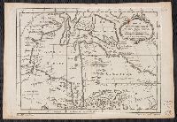
"Tom XIV. In 4⁰. No. 14. Tome 14. In 8⁰. Page 191.", Appears in Jean Francois de La Harpe's Abrégé de l'historie generale des voyages., Relief shown pictorially., and Sheet measures 24.4 x 35.5 cm. Cross Collection no. 179.
Publisher:
s.n.],
Subject (Geographic):
Hudson Bay Region--Maps--Early works to 1800 and Hudson Bay--Maps--Early works to 1800
Subject (Name):
La Harpe, Jean-François de, 1739-1803. Abrégé de l'Histoire générale des voyages