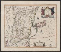
A variant of second state of the latinized atlas version of "Le Japon divisé en soissante et six provinces ...," with date "1715" below imprint. See: Lutz Walter, Japan: a cartographic vision, entry OAG 73 and Includes inset of Nagasaki and its surroundings.
Subject (Geographic):
Japan--Maps--Early works to 1800
Subject (Name):
Ottens, Joachim, 1663-1719, publisher and Ruyter, Balthasar, engraver
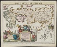
Keulen, Gerard van Keulen, Johannes van, fl. 1726-1753. Nieuwe groote lichtende zee-fakkel
Call Number:
303cea 1680
Container / Volume:
BRBL_00033
Image Count:
1
Resource Type:
Maps, Atlases & Globes
Alternative Title:
New sea map of the whole North Sea and Nouvelle carte marine generale de la Mer du Nord
Description:
Appeared in Joannes van Keulen's De Nieuwe groote, Backed with paper. Sheets measure 61.0 x 52.2 cm or smaller., Includes five bar scales., Relief shown pictorially; depth shown by soundings., and Scale estimated by measurement of degree of latitude.
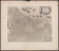
Coordinates not present on map and are approximated., From Joan Blaeu's Atlas maior (1662)., Latin text on verso; paginated ij-j, with caption Belgica., Relief shown pictorially., and With north oriented towards the upper right.
Subject (Geographic):
Netherlands--Maps--Early works to 1800
Subject (Name):
Blaeu, Joan, 1596-1673. Atlas maior, Ende, Josua van den, approximately 1584-approximately 1634, engraver, and Typographia Blaviani
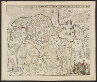
Appeared in Willem and Joan Blaeu's Theatrum orbis terrarum., Backed with linen., Coordinates not present on map and are approximated., Relief shown pictorially., and With north oriented towards the upper right.
Subject (Geographic):
Netherlands--Maps--Early works to 1800
Subject (Name):
Blaeu, Joan, 1596-1673. Theatrum orbis terrarum, Blaeu, Willem Janszoon, 1571-1638. Theatrum orbis terrarum, and Ende, Josua van den, approximately 1584-approximately 1634, engraver
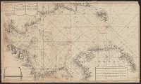
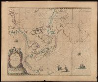
Sea chart of Australia (Hollandia Nova) Southeast Asia, China, Japan, Korea and India. Three Dutch galleons appear in the lower right corner of the map.
Description:
Bar scales in Dutch, Spanish and English miles., From: Pieter Goos' op't Waeter inde Vergulde Zeespiegel, 1666., North oriented to the left., and Relief shown pictorially.
Subject (Geographic):
Asia--Maps--Early works to 1800., Australia--Maps--Early works to 1800., and Southeast Asia--Maps--Early works to 1800.