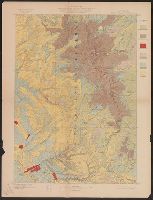
"Julius Bien & Co. Lith. N.Y.", "Surveyed in 1897-99.", Plate CXL from the "Twenty-first annual report" of the U.S. Geological Survey, Part 5, Forest reserves (1900)., Relief shown by contours and spot heights., and Shows six classes of land cover.
Publisher:
The Survey,
Subject (Geographic):
Big Horn County (Wyo.)--Maps, Bighorn National Forest (Wyo.)--Maps, and Johnson County (Wyo.)--Maps
Subject (Name):
Geological Survey (U.S.). Annual report and Matthes, François, 1874-1948
Subject (Topic):
Forests and forestry--Wyoming--Big Horn County--Maps, Forests and forestry--Wyoming--Johnson County--Maps, Land capability for agriculture--Wyoming--Big Horn County--Maps, and Land capability for agriculture--Wyoming--Johnson
"Julius Bien & Co. Lith. N.Y.", "Surveyed in 1899.", Plate CXXXVIII from the "Twenty-first annual report" of the U.S. Geological Survey, Part 5, Forest reserves (1900)., Relief shown by contours and spot heights., and Shows six classes of land cover.
Publisher:
The Survey,
Subject (Geographic):
Bighorn National Forest (Wyo.)--Maps and Sheridan County (Wyo.)--Maps
Subject (Name):
Geological Survey (U.S.). Annual report, Julius Bien & Co, and Tweedy, Frank, 1854-1937
Subject (Topic):
Forests and forestry--Wyoming--Sheridan County--Maps and Land capability for agriculture--Wyoming--Sheridan County--Maps
"Engraved Apr. 1901 by Julius Bien & Co.", "Surveyed, Plate CXLI from the "Twenty-first annual report" of the U.S. Geological Survey, Part 5, Forest reserves (1900)., Relief shown by contours and spot heights., and Shows four classes of land cover.
Publisher:
The Survey,
Subject (Geographic):
Black Hills National Forest (S.D. and Wyo.)--Maps and Weston County (Wyo.)--Maps
Subject (Name):
Geological Survey (U.S.). Annual report and Julius Bien & Co
Subject (Topic):
Forests and forestry--Wyoming--Weston County--Maps and Land capability for agriculture--Wyoming--Weston County--Maps
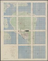
"1871.", "Approximate latitude of Park Pt., 44⁰23ʹ, approximate longitude of Park Pt., 110⁰20ʹ.", "Soundings are in fathoms.", At head of title: Department of the Interior, U.S. Geological Survey of the Territories., From the Survey's 5th annual report., and Relief shown by hachures and spot heights. Depths shown by soundings.
Publisher:
Geological Survey of the Territories,
Subject (Geographic):
Yellowstone Lake (Wyo.)--Maps and Yellowstone National Park--Maps
Subject (Name):
Elliott, Henry Wood, 1846-1930, Geological Survey of the Territories (U.S.), Hayden, F. V. (Ferdinand Vandeveer), 1829-1887, and Schönborn, A