Skip to search
Skip to main content
Skip to first result
Search
You Searched For
Genre
Nautical charts
Resource Type
Maps, Atlases & Globes
Subject (Topic)
World maps--Early works to 1800
New Search
Search Results
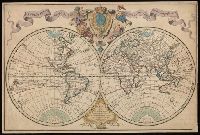
Creator:
Published / Created:
1720
Call Number:
11 1720
Image Count:
1
Resource Type:
Maps, Atlases & Globes
Description:
Cross collection no. 30., Includes ill., Relief shown pictorially., Shows nautical exploration routes., and Watermark.
Publisher:
Chez Guillaume Delisle, premier geographe du roy, de l'Academie royale des sciences, sur le quay de l'horloge, avec privilege,
Subject (Topic):
Nautical charts., Navigation, and World maps--Early works to 1800
Found in:
Beinecke Rare Book and Manuscript Library > Mappemonde a l'usage du roy [cartographic material] / par Guillaume Delisle, premier geographe de S.M.
Creator:
Published / Created:
1700
Call Number:
11 1700
Container / Volume:
BRBL_00004
Image Count:
1
Resource Type:
Maps, Atlases & Globes
Alternative Title:
New and correct sea chart of the whole world shewing the variations of the compass as they were found in the year MDCC and Nova et accuratissima totius terrarum orbis tabula nautica, variationum magneticarum index juxta observationes anno. 1700
Description:
Text at bottom: "Sold by R. & W. Mount and T. Page in Postern Row, Tower Hill".
Publisher:
Sold by R. Mount & T. Page ... ,
Subject (Topic):
World maps--Early works to 1800
Found in:
Beinecke Rare Book and Manuscript Library > Nova & accuratissima totius terrarum orbis tabula nautica, variationum magneticarum index juxta observationes anno. 1700 ... / per Edm: Halley ; I Harris sculp. = A new and correct sea chart of the whole world shewing the variations of the compass as they
Branch:v1.61.6 ,Deployed:2024-06-12T09:55:37-04:00