Skip to search
Skip to main content
Skip to first result
Search
You Searched For
Extent of Digitization
Partially digitized
Format
cartographic
Genre
Engravings
New Search
Search Results
Creator:
Published / Created:
1614
Call Number:
Bg4 035y
Image Count:
6
Description:
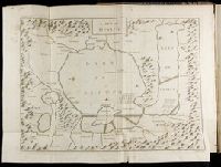
"The first part of the Historie of the vvorld .. The third booke" (caption title) begins new pagination on 4A1r., Anonymous. By Sir Walter Raleigh., Includes indexes and errata., Maps are hand colored. Autograph and inscription opposite p. 1 of the third book: John Bird, Galby, Leicestershire. 1768 and 1780., Maps are tab bound between noted pages., Printer's name and bookseller's address from colophon., Signatures: pi³ A-E⁴ a-c⁶ d² B-3I⁶ 3K⁴ 4A-6T⁶ 6V-6Y⁴ 7A-7C⁶., and The title page is engraved and signed: Ren: Elstrack sculpsit.
Publisher:
Printed [by William Stansby] for Walter Burre [, and are to be sold at his shop in Paules Church-yard at the signe of the Crane],
Subject (Geographic):
Arabian Peninsula--Maps--Early works to 1800, Middle east --Maps --Early works to 1800, and Palestine--Maps--Early works to 1800
Subject (Name):
Bird, John, fl. 1768-1780 --Autograph
Subject (Topic):
History, Ancient and Punic War, 2nd, 218-201 B.C.--Early works to 1800
Found in:
Beinecke Rare Book and Manuscript Library > The history of the world.
Creator:
Call Number:
C6 033c
Collection Title:
The natural and civil history of the French dominions in North and South America : with an
Image Count:
1
Resource Type:
Maps, Atlases & Globes
Description:
Plate between p. 2-3.
Subject (Geographic):
Atlantic Ocean--Charts, maps, etc., Atlantic Ocean--Maps--Early works to 1800, and Santo Domingo (Dominican Republic)
Collection Created:
London, Printed for T. Jeffreys, 1761
Found in:
Beinecke Rare Book and Manuscript Library > The island of Hispaniola called by the French St. Domingo. Subject to France and Spain. from the best authorities by Thomas Jeffreys, geographer to his Royal Highness the Prince of Wales
Call Number:
1973 Folio 114
Collection Title:
The English pilot: describing the West-India navigation, from Hudson's-Bay to the river Amazones
Image Count:
1
Resource Type:
Maps, Atlases & Globes
Subject (Geographic):
Atlantic Ocean --Maps --Early works to 1800, Jamaica --Maps --Early works to 1800, and West Indies --Maps --Early works to 1800
Subject (Topic):
Navigation --Early works to 1800, Pilot guides --Atlantic Coast (U.S.) --Early works to 1800, and Pilot guides --Caribbean Area --Early works to 1800
Collection Created:
London : Printed for W. and J. Mount, T. Page and son, on Tower-Hill, MDCCLIX [1759]
Found in:
Beinecke Rare Book and Manuscript Library > The island of Jamaica
Published / Created:
[ca. 1625]
Call Number:
Pequot +P978
Collection Title:
Purchas his pilgrimes : In fiue bookes. The first, contayning the voyages and peregrinations made
Image Count:
1
Description:
Bound in following p. 400.
Subject (Geographic):
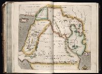
America--Discovery and exploration--Early works to 1800 and China--Maps--Early works to 1800
Subject (Topic):
Geography--Early works to 1800, Religions--Early works to 1800, and Voyages and travels--Early works to 1800
Collection Created:
London :
Found in:
Beinecke Rare Book and Manuscript Library > The map of China
Creator:
Published / Created:
ann. 1605.
Call Number:
1976 Folio 46
Image Count:
1
Resource Type:
Maps, Atlases & Globes
Alternative Title:
Mariners mirrour.
Description:
Map oriented with North at bottom left.
Publisher:
Jodocus Hondius excudit,
Subject (Geographic):
Great Britain --Maps --Early works to 1800, Netherlands --Maps --Early works to 1800, and North Sea --Maps --Early works to 1800
Found in:
Beinecke Rare Book and Manuscript Library > The mariners mirrovr wherin may playnly be seen the courses, heights, distances, depths, sounding, flouds and ebs, risings of lands, rocks ... of the harbouroughs, havens and ports of the greatest part of Europe: ... together w.th the rules and instrumeíÄ
Creator:
Published / Created:
[ca. 1625]
Call Number:
Pequot +P978
Collection Title:
Purchas his pilgrimes : In fiue bookes. The first, contayning the voyages and peregrinations made
Image Count:
1
Description:
Bound in following p. 852.
Subject (Geographic):
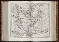
America--Discovery and exploration--Early works to 1800
Subject (Topic):
Geography--Early works to 1800, Religions--Early works to 1800, and Voyages and travels--Early works to 1800
Collection Created:
London :
Found in:
Beinecke Rare Book and Manuscript Library > The north part of America
Call Number:
1977 +392
Collection Title:
A survey of the cities of London and Westminster : containing the original, antiquity, increase
Image Count:
1
Resource Type:
Maps, Atlases & Globes
Description:
Plate between p. 44-45.
Subject (Geographic):
London (England)--History
Collection Created:
London : Printed for A. Churchill, J. Knapton, R. Knaplock, J. Walthoe [and 6 others], 1720
Found in:
Beinecke Rare Book and Manuscript Library > The parish of St. Johns Wapping
Branch:v1.61.8 ,Deployed:2024-06-20T11:14:46-04:00