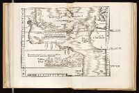
Navtica mediterranea / di Bartolomeo Crescentio Romano ... Nella quale si mostra la fabrica delle
Image Count:
1
Description:
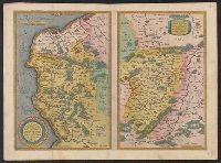
Map bound in at end., Map cut and folded irregularly., Map done on two separate sheets and pasted together in center., Map has several small gray and black smudges on both the recto and verso that appear to be fingerprints left during the engraving process., Map has several small yellow and brown marks, most notably on verso, although one can be seen on recto in lower right section., and Scale [ca. 1:6,500,000].
Subject (Geographic):
Mediterranean Region --Maps --Early works to 1800 and Mediterranean Sea --Navigation --Early works to 1800
Subject (Topic):
Galleys --Early works to 1800, Navigation --Early works to 1800, and Pilot guides --Mediterranean Sea --Early works to 1800
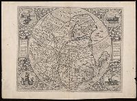
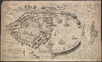
Appeared in Jode's Speculum orbis terrarum, Blank on verso., Engraving attributed to Antonie Wierix., Manuscript number on verso "No. 114.", Margins include descriptive text and four allegorical-historical vignettes (each 7 cm in diameter)., Relief shown pictorially., and Watermark.
Anno a Christi natiuitate 1525. Tertio Kal'. Apriles.
Call Number:
1976 +325
Image Count:
1
Resource Type:
Books, Journals & Pamphlets
Description:
Each map is printed across two leaves of plates. Maps 1 to 49 are numbered and have text on recto of initial leaf; final map is unnumbered, has no text on recto of initial leaf., Imprint information from colophon (leaf Q8 recto)., Index ([68] p., third group) bound at end, after maps., Signatures: A-M⁶ N⁴ 0-P⁶ Q⁸ a-e⁶ f⁴., and Variant order of binding: index precedes maps. Autograph of Giovanni Battista Francino.
Publisher:
Iohannes Grieningerus, communibus Iohannis Koberger impensis excudebat,
Subject (Name):
Francino, Giovanni Battista,--1631-1698--Autograph. and Regiomontanus, Joannes, 1436-1476.
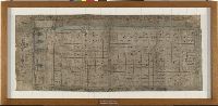
Figures along the left border portray a succession of Indian governors of Mexico City, ca. 1536-1565, consisting of Don Diego de Alvarado Huanitzin (Panitzin), Don Diego de San Francisco Tehuetzquititzin, Don Esteban de Guzmán, Don Cristóbal de Cecepátic (Cecetzin), and Don Luis de Santa María Cipac (Nanacacipactzin), in addition to a Spanish governor, identified as probably Don Luis de Velasco, Viceroy of New Spain. Each figure includes a name glyph and number of years that they held their colonial office., Footprints depicted along the left edge of the map probably represent a road or footpath. Figures along the upper edge of the map symbolize forty-one solar years. A strip of water depicted along the lower edge of the map may signify a lake, canal, or other body of water, which irrigates the rows of plants and traverses the map, and becomes paralleled in the upper margin by a representation of a Catholic church and a row of seven native houses., and Nahuatl map on maguey paper documenting agricultural holdings in the Valley of Mexico, probably fields of bulrush or maize under the colonial jurisdiction of Tenochtitlan-Mexico City, ca. 1565.
Alternative Title:
Aztec land map
Description:
Title devised by cataloger.
Subject (Geographic):
Mexico City (Mexico)--Maps, Manuscript--Early works to 1800, Mexico, Valley of (Mexico)--Maps, Manuscript--Early works to 1800, Mexico--Discovery and exploration--Maps, and Mexico--History--Spanish colony, 1540-1810
Subject (Name):
Alvarado Huanitzin, Don Diego de, Cecepátic, Don Cristóbal de, Guzmán, Don Esteban de, San Francisco Tehuetzquititzin, Don Diego de, Santa María Cipac, Don Luis de, and Velasco, Luis de,--1500?-1564
Subject (Topic):
Agriculture--Mexico--Maps, Corn--Mexico, Indian cartography, and Indians of Mexico