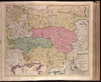
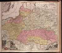
"Cum privilegio.", Appears in Justus Danckerts's Atlas editions after 1696; see Koeman, C. Atlantes Neerlandici, vol. III, Dan 3, Dan 4., Bar scales given in "milliaria Garmanica communia" and "milliaria Gallica"., Imperfect: slightly stained on recto and verso, with no loss of text. Backed with paper. Ms. no. in upper right corner: 26. Sheet measures 53.7 x 62.6 cm. No. 26 of 87 maps bound together., Prime meridian: Ferro., Relief shown pictorially., Watermark., and With inset map "Comit. Tirolis".
Publisher:
[Justus Danckerts,
Subject (Geographic):
Austria--Maps--Early works to 1800. and Slovenia--Maps--Early works to 1800.
"Cum privilegio ord. Holl. et West-frisiae"., Backed with paper. Ms. no. "8" in upper right-hand corner. Sheet measures 53.4 x 62.6 cm. No. 7 of 87 maps bound together., Bar scales given in "milliaria Germanica" and "mill. Danica et Suecia"., Prime meridian: Ferro., Relief shown pictorially., and Watermark.
Publisher:
[Peter Schenk],
Subject (Geographic):
Denmark--Maps--Early works to 1800. and Germany, Northern--Maps--Early works to 1800.
"Amstelodami cum privilegio D.D. ordin. Hollandiae Westfrisiaeq[ue].", Backed with paper., Illustrated hand colored title cartouche; sea decorated with ships., Prime meridian: Ferro., and Relief shown pictorially.
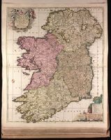
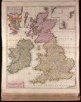
"Cum privilegio.", Backed with paper. Ms. no. "49" in lower-right corner. Sheet measures 63.1 x 53.8 cm. No. 46 of 87 maps bound together., Includes four bar scales., Prime meridian: Ferro., Relief shown pictorially., and Watermark.
Publisher:
[Peter Schenk,
Subject (Geographic):
Ireland--Maps--Early works to 1800.
Subject (Name):
Schenk, Peter, 1660-1718 or 1719. Atlas contractus.
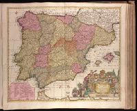
"Cum privil. Regis Polon. et Elect. Sax. et Hollandiae et Westfrisiae.", Backed with paper. Ms. no. "63" in upper right-hand corner. Sheet measures 53.5 x 62.3 cm. No. 58 of 87 maps bound together., Bar scales given in "milliaria Germanica," "milliaria Hispanica," and "mill. Gallica.", Prime meridian: Ferro., Relief shown pictorially., and Watermark.
Publisher:
[Peter Schenk],
Subject (Geographic):
Portugal--Maps--Early works to 1800. and Spain--Maps--Early works to 1800.
"Cum privilegio Reg. Pott. et Elect. Saxoniae et Ord. Hol. et Westfrisiae"., Backed with paper. Ms. no. "46" in lower right-hand corner. Sheet measures 63.1 x 53.7 cm. No. 43 of 87 maps bound together., Includes four bar scales., Prime meridian: Ferro., Relief shown pictorially., Watermark., and With inset map of Shetland and Faroe Islands.
"Cum privilegio ordinum Hollandiae & Westfrisie.", Backed with paper. Sheet measures 53.8 x 62.3 cm. No. 79 of 87 maps bound together., Bar scales given in "milliaria Germanica" and "milliaria Gallica.", and Relief shown pictorially.
Publisher:
[Gerard van Keulen,
Subject (Geographic):
Baltic States--Maps--Early works to 1800., Poland--Maps--Early works to 1800., and Ukraine--Maps--Early works to 1800.
Adrichem, Christiaan van, 1533-1585, cartographer.
Published / Created:
[between 1652 and 1684]
Call Number:
BrSides Double Folio 2019 97
Image Count:
1
Resource Type:
Maps, Atlases & Globes
Description:
Coordinates not present on map and are approximated., Manuscript number in upper left corner: 42., Oriented with north to the lower left., Relief shown pictorially., and Verso blank.
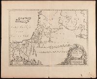
Tabvla itineraria patriarcharvm Abrahami, Isaaci et Jacobi
Description:
Includes three bar scales., Relief shown pictorially., Shows the itineraries of the patriarchs, Abraham, Isaac, and Jacob, especially in Canaan and the Nile Delta., and Watermark. Manuscript number in upper left corner: 39.
Publisher:
Apud Ioannem Ianssonium,
Subject (Geographic):
Middle East--Maps--Early works to 1800., Palestine--History--To 70 A.D.--Maps--Early works to 1800., and Palestine--Maps--Early works to 1800.
Subject (Topic):
Bible.--Old Testament--Geography--Maps--Early works to 1800.