Skip to search
Skip to main content
Skip to first result
Search
You Searched For
Resource Type
Maps, Atlases & Globes
Publication Place
[Ottawa] :
New Search
Search Results
Creator:
Published / Created:
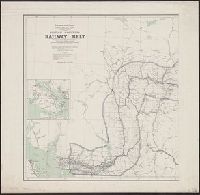
1908
Call Number:
739 1908
Container / Volume:
BRBL_00388
Image Count:
2
Resource Type:
Maps, Atlases & Globes
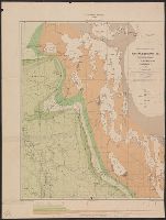
Description:
"Corrected to February 1st, 1908.", Indicates "lands disposed of, also timber berths.", Inset: Vancouver Island (Scale [ca. 1:1,267,200])., and Relief shown by spot heights.
Publisher:
The Department,
Subject (Geographic):
British Columbia--Maps
Subject (Name):
White, James, 1863-1928 and Young, R. E
Subject (Topic):
Railroads--British Columbia--Maps
Found in:
Beinecke Rare Book and Manuscript Library > British Columbia railway belt / Dept. of the Interior ; prepared under the direction of R.E. Young, Superintendent of Railway and Swamp Lands ; James White, F.R.G.S., geographer.
Creator:
Published / Created:
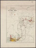
1907
Call Number:
739G 1907
Container / Volume:
BRBL_00392
Image Count:
2
Resource Type:
Maps, Atlases & Globes
Description:
"Corrected to July 1st, 1907.", Indicates "lands disposed of, also timber berths.", and Relief shown by spot heights.
Publisher:
The Department,
Subject (Geographic):
British Columbia--Maps
Subject (Name):
White, James, 1863-1928 and Young, R. E
Subject (Topic):
Railroads--British Columbia--Maps
Found in:
Beinecke Rare Book and Manuscript Library > British Columbia railway belt / Dept. of the Interior; prepared under the direction of R.E. Young, Superintendent of Railway and Swamp Lands; James White, F.R.G.S., geographer.
Creator:
Published / Created:
1916
Call Number:
736gck 1915
Container / Volume:
BRBL_00383
Image Count:
1
Resource Type:
Maps, Atlases & Globes
Description:
"Base map from plates of Geographer's Branch, Dept. of the Interior." and Relief shown by spot heights.
Publisher:
Dept. of the Interior,
Subject (Geographic):
Manitoba--Maps
Subject (Topic):
Grain--Manitoba--Maps
Found in:
Beinecke Rare Book and Manuscript Library > Cereal map of Manitoba [cartographic material] : showing acreage under crop in each township in wheat, oats, barley and flax during 1915 / prepared in the Railway Lands Branch under the direction of F.C.C. Lynch, Superintendent from data supplied by the P
Creator:
Published / Created:
[1912]
Call Number:
737CBF 1912
Container / Volume:
BRBL_00386
Image Count:
1
Resource Type:
Maps, Atlases & Globes
Alternative Title:
Bow River Basin above Calgary
Description:
Relief shown by contours and spot heights.
Publisher:
Dept. of the Interior Water Power Branch,
Subject (Geographic):
Bow River Region (Alta.)--Maps
Subject (Name):
Hendry, M. C
Subject (Topic):
Watersheds--Alberta--Maps
Found in:
Beinecke Rare Book and Manuscript Library > Contour map of Bow River Basin above Calgary [Alberta] : to accompany report on power and storage investigation / by M.C. Hendry.
Creator:
Published / Created:
1923
Call Number:
73gck 1923
Container / Volume:
BRBL_00376
Image Count:
1
Resource Type:
Maps, Atlases & Globes
Description:
Insets: Map of the Dominion of Canada showing licensed elevators located at points outside of main map -- Diagram showing Canadian grain crops and values for past fifteen years.
Publisher:
Natural Resources Intelligence Service,
Subject (Topic):
Grain elevators--Prairie Provinces--Maps
Found in:
Beinecke Rare Book and Manuscript Library > Elevator map of Manitoba, Saskatchewan & Alberta / prepared by the Natural Resources Intelligence Service.
Creator:
Published / Created:
1904
Call Number:
18 1904
Container / Volume:
BRBL_00013
Image Count:
1
Resource Type:
Maps, Atlases & Globes
Description:
27 coastal sections with names of explorers; tracks of expedition.
Publisher:
Canada. Dept. of the Interior,
Subject (Geographic):
Canada, Northern--Discovery and exploration--Maps
Subject (Name):
White, James, 1863-1928
Found in:
Beinecke Rare Book and Manuscript Library > Explorations in northern Canada and adjacent portions of Greenland and Alaska [map] / James White.
Creator:
Published / Created:
1904
Call Number:
74 1904B
Container / Volume:
BRBL_00394
Image Count:
1
Resource Type:
Maps, Atlases & Globes
Description:
27 coastal sections with names of explorers; tracks of expedition.
Publisher:
Canada. Dept. of the Interior,
Subject (Geographic):
Canada, Northern--Discovery and exploration--Maps
Subject (Name):
White, James, 1863-1928
Found in:
Beinecke Rare Book and Manuscript Library > Explorations in northern Canada and adjacent portions of Greenland and Alaska [map] / James White.
Creator:
Published / Created:
1899
Call Number:
736CA W73 1899
Container / Volume:
BRBL_00382
Image Count:
1
Resource Type:
Maps, Atlases & Globes
Description:
"664.", Depth shown by soundings., and Includes geological legend.
Publisher:
Geological Survey of Canada,
Subject (Name):
Dowling, D. B. (Donaldson Bogart), 1858-1925 and Geological Survey of Canada
Subject (Topic):
Geology--Manitoba--Winnipeg, Lake, Region--Maps
Found in:
Beinecke Rare Book and Manuscript Library > Geological map of Lake Winnipeg and vicinity / by J.B. Tyrrell and D.B. Dowling.
Creator:
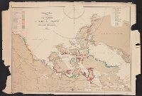
Published / Created:
1891
Call Number:
736CA 1891
Container / Volume:
BRBL_00382
Image Count:
1
Resource Type:
Maps, Atlases & Globes
Alternative Title:
[Multicoloured geological maps] ; no. 339
Description:
Includes cross section. and Relief shown by contours ; depth shown by soundings.
Publisher:
Geological Survey Dept.,
Subject (Name):
Dowling, D. B. (Donaldson Bogart), 1858-1925 and Geological Survey of Canada
Subject (Topic):
Geology--Manitoba--Lake Winnipegosis Region--Maps
Found in:
Beinecke Rare Book and Manuscript Library > Geological map of north western Manitoba and portions of the districts of Assiniboia and Saskatchewan [cartographic material] / by J. B. Tyrrell ; assisted by D. B. Dowling.
Creator:
Published / Created:
1905?]
Call Number:
735gfc B418 1905
Container / Volume:
BRBL_00382
Image Count:
1
Resource Type:
Maps, Atlases & Globes
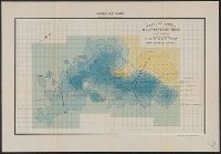
Alternative Title:
Belmont Iron Mine
Description:
"Magnetic survey made Aug. 1905. B.F. Haanel"--Lower right margin., Also shows buildings, railroads, wagon roads, ore dumps, pits, and deep workings., Oriented with north to the upper right., Scale inferred from similar maps., and Similar map accompanies text: Ma
Publisher:
Dept. of the Interior [Mines Branch,
Subject (Geographic):
Belmont (Ont. : Township)--Maps and Belmont Iron Mine (Ont.)--Maps
Subject (Name):
Canada. Dept. of the Interior, Canada. Mines Branch, Haanel, B. F. (Benjamin F.), 1877-1957, and Lindeman, E. (Einar), b. 1877. Magnetite occurrences along the Central Ontario Railway
Subject (Topic):
Geomagnetism--Ontario--Belmont (Township)--Maps, Geomagnetism--Ontario--Peterborough (County)--Maps, Iron mines and mining--Ontario--Belmont (Township)--Maps, Iron mines and mining--Ontario--Peterborough (County)--Maps, Iron ores--Ontario--Belmont (Township)--Maps, and Iron ores--Ontario--Peterborough (County)--Maps
Found in:
Beinecke Rare Book and Manuscript Library > Magnetic survey of the Belmont Iron Mine : lot 19, con. 1, Township of Belmont, County of Peterboro, Province of Ontario : map of the vertical intensity / Eugene Haanel, Superintendent of Mines ; surveyed by B.F. Haanel.
Branch:v1.61.6 ,Deployed:2024-06-12T09:55:19-04:00