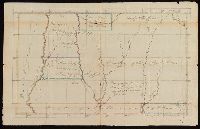
Coordinates not present on map and are approximated., From the Nathaniel Pendleton family papers., Prime meridians: Philadelphia and London., Shows lands of the Cherokee, Creek, and Chickasaw Indian tribes. Also shows lands designated for the Tennessee, South-Carolina Yazoo, and Virginia Yazoo Companies., Title from verso of map., and Watermark.
Subject (Geographic):
Chickasaw Nation--Maps--Early works to 1800., Choctaw Nation--Maps--Early works to 1800., Creek Nation--Maps--Early works to 1800., and Mississippi--Maps--Early works to 1800.
Subject (Name):
Pendleton, Nathaniel,--1756-1821, South-Carolina Yazoo Company., Tennessee Company., and Virginia Yazoo Company.
Subject (Topic):
Public lands--Georgia--Early works to 1800., Real property--Mississippi--Maps--Early works to 1800., and Yazoo Fraud, 1795--Maps--Early works to 1800.
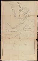
Coordinates not present on map and are approximated., Depths shown by soundings., From the Nathaniel Pendleton family papers., North oriented towards the right., Shows channel between Cumberland and Amelia Islands on the Georgia/Florida border where the Saint Marys River flows out to the Atlantic., Title devised by cataloger., and Watermark.
Subject (Geographic):
Saint Marys River (Ga. and Fla.)--Maps--Early works to 1800.