Skip to search
Skip to main content
Skip to first result
Search
You Searched For
Genre
Manuscript maps
Resource Type
Maps, Atlases & Globes
Subject (Name)
Rickard, Richard H.,---1885--Ownership.
New Search
Search Results
Creator:
Published / Created:
1861
Call Number:
BrSides Folio 2018 140
Image Count:
1
Resource Type:
Maps, Atlases & Globes
Description:
Coordinates not present on map and are approximated., From the Richard H. Rickard Papers., and North oriented towards the left.
Publisher:
Department of Crown Lands,
Subject (Name):
Montreal Mining Company., Ontario. Department of Crown Lands., and Rickard, Richard H.,---1885--Ownership.
Subject (Topic):
Mines and mineral resources--Ontario.
Found in:
Beinecke Rare Book and Manuscript Library > Copy of part of P.L.S. Salter's plan shewing mineral locations at and near Mamainse with a projection shewing Montreal Mining Company's location / Andrew Russell, Assistant Commissioner.
Published / Created:
[between 1850 and 1859?]
Call Number:
BrSides 2018 156
Image Count:
1
Resource Type:
Maps, Atlases & Globes
Description:
From the Richard H. Rickard Papers., Shows mine locations in Madison County, Virginia., and Title from verso of sheet.
Subject (Name):
Rickard, Richard H.,---1885--Ownership.
Subject (Topic):
Copper mines and mining--Virginia--Madison County--Maps.
Found in:
Beinecke Rare Book and Manuscript Library > Map showing copper lands in Virginia.
Creator:
Published / Created:
2nd Feby. 1877.
Call Number:
BrSides Double Folio 2018 97
Image Count:
1
Resource Type:
Maps, Atlases & Globes
Description:
Coordinates not present on map and are approximated., From the Richard H. Rickard Papers., and Title devised by cataloger.
Publisher:
Department of Crown Lands,
Subject (Name):
Ontario. Department of Crown Lands. and Rickard, Richard H.,---1885--Ownership.
Subject (Topic):
Mines and mineral resources--Ontario--Thunder Bay Region--Maps. and Real property--Ontario--Thunder Bay Region--Maps.
Found in:
Beinecke Rare Book and Manuscript Library > McIntyre / Thos. H. Johnson, Assistant Commissioner.
Published / Created:
[1872?]
Call Number:
BrSides Folio 2018 141
Image Count:
1
Resource Type:
Maps, Atlases & Globes
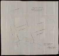
Description:
From the Richard H. Rickard Papers., Illegible stamps with date "Mar 8 1872.", and Title devised by cataloger.
Subject (Name):
Rickard, Richard H.,---1885--Ownership.
Subject (Topic):
Mines and mineral resources--Ontario--Thunder Bay Region--Maps. and Real property--Ontario--Thunder Bay Region--Maps.
Found in:
Beinecke Rare Book and Manuscript Library > [Manuscript cadastral map of mine veins in Thunder Bay District, Canada].
Published / Created:
[between 1875 and 1900?]
Call Number:
BrSides Folio 2018 133
Image Count:
1
Resource Type:
Maps, Atlases & Globes
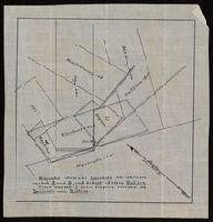
Description:
Chipped and torn along folds., From the Richard H. Rickard Papers., and Title devised by cataloger.
Subject (Name):
Rickard, Richard H.,---1885. and Rickard, Richard H.,---1885--Ownership.
Subject (Topic):
Real property--Maps
Found in:
Beinecke Rare Book and Manuscript Library > [Manuscript map of delineations of unknown property owned by Richard H. Rickard].
Published / Created:
[between 1875 and 1900?]
Call Number:
BrSides 2018 155
Image Count:
1
Resource Type:
Maps, Atlases & Globes
Description:
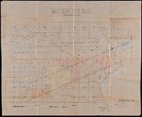
"Magnolia adversed Ypsilanti on conflicts marked A and B, and did not adverse Bullion. Piece marked C is in dispute between the Ypsilanti and Bullion.", From the Richard H. Rickard Papers., and Title devised by cataloger.
Subject (Name):
Rickard, Richard H.,---1885--Ownership.
Subject (Topic):
Copper mines and mining--Michigan--Maps.
Found in:
Beinecke Rare Book and Manuscript Library > [Manuscript map of mine locations in Michigan].
Published / Created:
[between 1875 and 1900?]
Call Number:
BrSides Box 2018 74
Image Count:
1
Resource Type:
Maps, Atlases & Globes
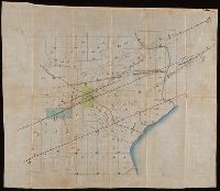
Description:
From the Richard H. Rickard Papers. and Title devised by cataloger.
Subject (Name):
Rickard, Richard H.,---1885--Ownership.
Subject (Topic):
Copper mines and mining--Michigan--Ontonagon County--Maps.
Found in:
Beinecke Rare Book and Manuscript Library > [Manuscript map of mine locations in the vicinity of Mass City, Michigan].
Published / Created:
[1872?]
Call Number:
BrSides Folio 2018 139
Image Count:
1
Resource Type:
Maps, Atlases & Globes
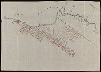
Alternative Title:
Map of Thunder Bay District, Canada, showing silver lands owned by Peter Mitchell and others
Description:
Accompanied by mailing envelope addressed in manuscript to R.H. Rickard., Coordinates not present on map and are approximated., From the Richard H. Rickard Papers., North oriented towards the upper right., and Title devised by cataloger from manuscript note on accompanying envelope.
Subject (Name):
Rickard, Richard H.,---1885--Ownership.
Subject (Topic):
Landowners--Ontario--Thunder Bay--Maps., Real property--Ontario--Thunder Bay--Maps., and Silver mines and mining--Ontario--Thunder Bay--Maps.
Found in:
Beinecke Rare Book and Manuscript Library > [Map of Thunder Bay District, Canada, showing silver lands owned by Peter Mitchell & others, Sept. 7th, 1872].
Branch:v1.61.6 ,Deployed:2024-06-12T09:55:36-04:00