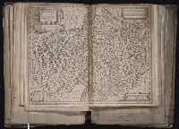
Appears in Blaeu's Atlas major., Bar scale given in milliaria Germanica., Ferro meridian., No. 61 of 69 maps bound together in composite atlas., Relief shown pictorially., and Scale [ca. 1:8 500 000].
Publisher:
[Joan Blaeu]
Subject (Geographic):
Africa, Central --Maps --Early works to 1800 and Africa, Eastern --Maps --Early works to 1800
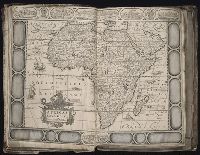
Appears in Blaeu's Atlas major., Bar scale given in milliaria Germanica communia., Ferro meridian., Includes illustration of animals and ornamental cartouche., No. 60 of 69 maps bound together in composite atlas., Relief shown pictorially., and Scale [ca. 1:12 000 000].
Publisher:
[Joan Blaeu]
Subject (Geographic):
Africa, Central --Maps --Early works to 1800 and Africa, Eastern --Maps --Early works to 1800
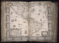
Africa distinguished into its principall parts viz. Barbary, Biledulgerid, Egypt, Zaara or the Desart, the Country of the Negroes, Guinea, Nubia, Abissinea, Zanguebar, Congo, Monomotapa, Caffrares, the Islands of the Canaries, Cape Verd, St. Thomas, Madagascar or St. Lawrence in which are observed the empires, monarchies, kingdomes, states and peoples, which at present inhabite Africa
Description:
Ferro meridian., No. 56 of 69 maps bound together in composite atlas., Relief shown pictorially., Scale [ca 1:34 000 000]., and To the most serene and most sacred majesty of Charles II, by the grace of God, king of Great Brittain, France, and Ireland, this map of Africa is humbly dedicated and presented by your majesties loyal subject and servant, William Berry.
Publisher:
Sold by William Berry at the sign of the globe between Charing Cross and White-Hall
[Atlas factice of 96 maps by Blaeu, Visscher, Jansson, Hondius and others]
Image Count:
1
Description:
Imperfect: torn along fold, with some loss of text; portions of decorative border cut or torn and repaired, with missing sections replicated in ms.; tears repaired. Sheet measures 44 x 56.3 cm. No. 4 of 92 maps bound together.
[Atlas factice of 96 maps by Blaeu, Visscher, Jansson, Hondius and others]
Image Count:
1
Description:
Imperfect: torn along fold, with some loss of text; portions of decorative border [six lower views of American settlements and all vignettes of Native Americans] cut or torn and repaired, with missing sections replicated in ms.; tears repaired. Sheet measures 45.7 x 54.6 cm. No. 22 of 92 maps bound together.
Publisher:
Jodocus Hondius
Subject (Geographic):
America --Maps --Early works to 1800, Antarctica --Maps --Early works to 1800, and Arctic regions --Maps --Early works to 1800