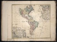
[Atlas factice of 96 maps by Blaeu, Visscher, Jansson, Hondius and others]
Image Count:
1
Description:
Imperfect: mutilated and repaired, with loss of cartouche and coat of arms and partial loss of eastern coast of England, replicated (minus coat of arms) in ms. with new cartouche title Anglia Regnum vulgo Engeland. Sheet measures 39.9 x 50 cm. No. 6 of 92 maps bound together.
Publisher:
Willem J. Blaeu
Subject (Geographic):
England --Maps --Early works to 1800 and Wales --Maps --Early works to 1800
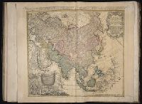
At head of map: Asia distinguished into its principall parts viz. Turky in Asia, Arabia, Persia, India, China, Tartaria, the islands of Japan, of the Philippines, of the Moluckes, of the Sundaes, of Ceylan, and of the Maldivies, where are set down the empires, monarchies, kingdoms, and states which are found there at present., Dedication in cartouche: To the most serene and most sacred majesty of Charles II by the grace of God, King of Great Brittain, France and Ireland. This map of Asia is humbly dedicated, and presented by your majesties loyal subject, and servant William Berry., Map of Asia from Saudi Arabia, Russia, India, China, Japan to Southeast Asia. Relief shown pictorially., No. 49 of 69 maps bound together in composite atlas., and Scale [ca. 1:12 165 120].
Publisher:
Sold by William Berry at the signe of the Globe between Charing-Cross and White-Hall
Subject (Geographic):
Asia --Maps --Early works to 1800, Asia, Central --Maps --Early works to 1800, South Asia --Maps --Early works to 1800, and Southeast Asia --Maps --Early works to 1800
Boehm, Augustus Gottlieb Hase, Johann Matthias, 1684-1742 Homann Erben (Firm)
Published / Created:
1744
Call Number:
1983 Folio 23
Collection Title:
[Atlas factice of 50 maps, primarily by Johann Baptist Homann and/or issued by the Homann Erben
Image Count:
1
Alternative Title:
Asia secundum legitimas projectionis stereographicae regulas et juxta recentissimas observationes and Carte de l’Asie, projettee stereographiquement, tiree des relations et observations
Boehm, Augustus Gottlieb Hase, Johann Matthias, 1684-1742 Homann Erben (Firm)
Published / Created:
1744
Call Number:
1975 Folio 31
Collection Title:
[Atlas factice of 42 maps, produced by the Homann Erben firm]
Image Count:
1
Alternative Title:
Asia secundum legitimas projectionis stereographicae regulas et juxta recentissimas observationes and Carte de l’Asie, projettee stereographiquement, tiree des relations et observations
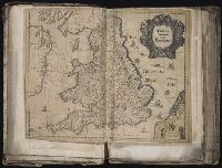
[Atlas factice of 96 maps by Blaeu, Visscher, Jansson, Hondius and others]
Image Count:
2
Resource Type:
Maps, Atlases & Globes
Description:
All four sides of map decorated with city views and costumed figures of different social classes. Includes coats of arms., Imperfect: torn along fold, with some loss of text; portions of decorative border cut or torn and repaired, with missing sections replicated in ms.; tears repaired., and No. 5 of 92 maps bound together.
Danckerts, Cornelis, ca. 1603-1656 Lazius, Wolfgang, 1514-1565
Published / Created:
[ca. 1631]
Call Number:
1983 Folio 19
Collection Title:
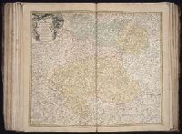
[Atlas factice of 96 maps by Blaeu, Visscher, Jansson, Hondius and others]
Image Count:
1
Description:
Imperfect: Trimmed along edges, with no loss of text. Reinforced along edges with printed waste. Sheet measures 39 x 51 cm. No. 81 of 92 maps bound together. and Numbered 87 in pencil, 85 in ink, on verso.