Skip to search
Skip to main content
Skip to first result
Search
You Searched For
Genre
Hand coloring
Genre
Maps
Genre
Maps in books
New Search
Search Results
Published / Created:
[1618]
Call Number:
Taylor 275
Collection Title:
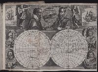
Journal ou relation exacte du voyage de Guill Schouten
Image Count:
1
Description:
Bound in after p. [8]., Busts of various explorers depicted around edges of map., Four small areas with stains on verso., Scale not given., and Western hemisphere of North and South America hand colored.
Subject (Topic):
Oceania --Discovery and exploration --Early works to 1800, Voyages around the world --Early works to 1800, and World maps --Early works to 1800
Collection Created:
A Paris : chez M. Gobert, au Palais en la gallerie des prisonniers, et les cartes, chez M. Tauernier, graueur du roy, demeurant au pont Marchand, 1618
Found in:
Beinecke Rare Book and Manuscript Library > [Double hemisphere map of the world showing track of Schouten’s voyage in 1615-1617]
Published / Created:
1610
Call Number:
BrSides Folio 2008 14
Collection Title:
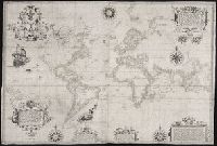
Certaine errors in nauigation / detected and corrected by Edw. Wright ; with many additions that
Image Count:
1
Description:
2d state, "William Kip sculpsit"., Formerly bound in Taylor 251., Housed and classed separately as BrSides Folio 2008 14., In pencil on verso: Beinecke / Library / Broadsides / Folio / 2008 / 14., Map has some small tears along previously folded edges that have been repaired., On verso: Yale proprietary stamp in center., and Scale not given.
Subject (Topic):
Nautical astronomy --Early works to 1800, Navigation --Early works to 1800, and Pilot guides --England --Early works to 1800
Collection Created:
[London] : Printed by Felix Kingsto[n] at London, 1610
Found in:
Beinecke Rare Book and Manuscript Library > [Edward Wright’s chart of the world]
Published / Created:
[1542]
Call Number:
Taylor 86
Collection Title:
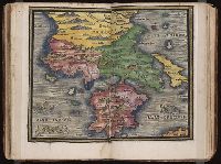
Rvdimenta cosmographica
Image Count:
1
Subject (Geographic):
Balkan Peninsula and Greece
Subject (Topic):
Cosmography, Early maps, and Geography, Medieval
Collection Created:
Impressvm in inclyta Transylvaniae Corona 1542
Found in:
Beinecke Rare Book and Manuscript Library > [Map of the Balkan Peninsula including Macedonia and Greece]
Published / Created:
[1542]
Call Number:
Taylor 86
Collection Title:
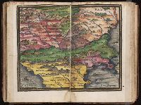
Rvdimenta cosmographica
Image Count:
1
Subject (Geographic):
Balkan Peninsula
Subject (Topic):
Cosmography, Early maps, and Geography, Medieval
Collection Created:
Impressvm in inclyta Transylvaniae Corona 1542
Found in:
Beinecke Rare Book and Manuscript Library > [Map of the Balkan Peninsula including Macedonia, Blugaria, Moldova]
Published / Created:
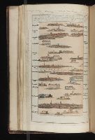
1802
Call Number:
Im B388 Zz802B
Collection Title:
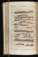
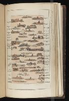
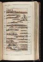
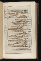
The imperial guide : with picturesque plans of the great post roads, containing miniatures
Image Count:
1
Description:
Bound in between p. 24-25. and William Beckford’s copy, with his penciled annotations. Autograph of William Beckford.
Subject (Geographic):
England --Guidebooks, England --Maps, Great Britain --Description and travel --Views, and Great Britain --Road maps
Subject (Topic):
Roads --Great Britain
Collection Created:
London : Printed by C. Whittingham, Dean Street, Fetter Lane, and sold by H.D. Symonds, Paternoster-Row; [etc], 1802
Found in:
Beinecke Rare Book and Manuscript Library > [Map: Carlisle to Bolton]
Published / Created:
1802
Call Number:
Im B388 Zz802B
Collection Title:
The imperial guide : with picturesque plans of the great post roads, containing miniatures
Image Count:
1
Description:
Bound in between p. 4-5. and William Beckford’s copy, with his penciled annotations. Autograph of William Beckford.
Subject (Geographic):
England --Guidebooks, England --Maps, Great Britain --Description and travel --Views, and Great Britain --Road maps
Subject (Topic):
Roads --Great Britain
Collection Created:
London : Printed by C. Whittingham, Dean Street, Fetter Lane, and sold by H.D. Symonds, Paternoster-Row; [etc], 1802
Found in:
Beinecke Rare Book and Manuscript Library > [Map: Coventry to Stony Stratford]
Published / Created:
1802
Call Number:
Im B388 Zz802B
Collection Title:
The imperial guide : with picturesque plans of the great post roads, containing miniatures
Image Count:
1
Description:
Bound in between p. 38-39. and William Beckford’s copy, with his penciled annotations. Autograph of William Beckford.
Subject (Geographic):
England --Guidebooks, England --Maps, Great Britain --Description and travel --Views, and Great Britain --Road maps
Subject (Topic):
Roads --Great Britain
Collection Created:
London : Printed by C. Whittingham, Dean Street, Fetter Lane, and sold by H.D. Symonds, Paternoster-Row; [etc], 1802
Found in:
Beinecke Rare Book and Manuscript Library > [Map: Islip to Paddington]
Published / Created:
1802
Call Number:
Im B388 Zz802B
Collection Title:
The imperial guide : with picturesque plans of the great post roads, containing miniatures
Image Count:
1
Description:
Bound in between p. 22-23. and William Beckford’s copy, with his penciled annotations. Autograph of William Beckford.
Subject (Geographic):
England --Guidebooks, England --Maps, Great Britain --Description and travel --Views, and Great Britain --Road maps
Subject (Topic):
Roads --Great Britain
Collection Created:
London : Printed by C. Whittingham, Dean Street, Fetter Lane, and sold by H.D. Symonds, Paternoster-Row; [etc], 1802
Found in:
Beinecke Rare Book and Manuscript Library > [Map: Lancaster to Worsley]
Published / Created:
1802
Call Number:
Im B388 Zz802B
Collection Title:
The imperial guide : with picturesque plans of the great post roads, containing miniatures
Image Count:
1
Description:
Bound in between p. 6-7. and William Beckford’s copy, with his penciled annotations. Autograph of William Beckford.
Subject (Geographic):
England --Guidebooks, England --Maps, Great Britain --Description and travel --Views, and Great Britain --Road maps
Subject (Topic):
Roads --Great Britain
Collection Created:
London : Printed by C. Whittingham, Dean Street, Fetter Lane, and sold by H.D. Symonds, Paternoster-Row; [etc], 1802
Found in:
Beinecke Rare Book and Manuscript Library > [Map: Stafford to Coventry]
Published / Created:
1802
Call Number:
Im B388 Zz802B
Collection Title:
The imperial guide : with picturesque plans of the great post roads, containing miniatures
Image Count:
1
Description:
Bound in between p. 10-11. and William Beckford’s copy, with his penciled annotations. Autograph of William Beckford.
Subject (Geographic):
England --Guidebooks, England --Maps, Great Britain --Description and travel --Views, and Great Britain --Road maps
Subject (Topic):
Roads --Great Britain
Collection Created:
London : Printed by C. Whittingham, Dean Street, Fetter Lane, and sold by H.D. Symonds, Paternoster-Row; [etc], 1802
Found in:
Beinecke Rare Book and Manuscript Library > [Map: Talk on the Hill to Birmingham]
Branch:v1.61.8 ,Deployed:2024-06-20T11:15:15-04:00