Skip to search
Skip to main content
Skip to first result
Search
You Searched For
Genre
Maps
Genre
Maps in books
Language
Spanish; Castilian
New Search
Search Results
Creator:
Call Number:
Zc70 +802ea
Collection Title:
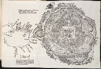
Relacion del viage hecho por las goletas Sutil y Mexicana en el ano de 1792, para reconocer el
Image Count:
1
Subject (Geographic):
California --Maps, San Diego (Calif.) --Maps, San Diego Bay (Calif.) --Maps, and Spain --Exploring expeditions
Subject (Name):
Alcala-Galiano, Dionisio, 1760-1805, Mexicana (Ship), Navarrete, Martin Fernandez de, 1765-1844, Sutil (Ship), and Valdes Flores Bazan y Peon, Cayetano, 1767-1835
Subject (Topic):
Nootka Indians
Collection Created:
Madrid, Imprenta real, 1802
Found in:
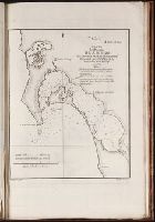
Beinecke Rare Book and Manuscript Library > Plano del puerto de S. Diego en la costa setentl. de Californs. Levantado por el 2o. piloto de la armada D. Juan Pantoja ano 1782. Map no. 5
Creator:
Call Number:
Zc70 +802ea
Collection Title:
Relacion del viage hecho por las goletas Sutil y Mexicana en el ano de 1792, para reconocer el
Image Count:
1
Subject (Geographic):
California --Maps, Monterey (Calif.) --Maps, Monterey Bay (Calif.) --Maps, and Spain --Exploring expeditions
Subject (Name):
Alcala-Galiano, Dionisio, 1760-1805, Mexicana (Ship), Navarrete, Martin Fernandez de, 1765-1844, Sutil (Ship), and Valdes Flores Bazan y Peon, Cayetano, 1767-1835
Subject (Topic):
Nootka Indians
Collection Created:
Madrid, Imprenta real, 1802
Found in:
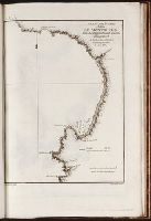
Beinecke Rare Book and Manuscript Library > Plano del puerto y bahia de Monte Rey situado en la costa de Californs. Trabajado a bordo de las corvetas descubierta y atrevida. Ano 1791. Map no. 6
Creator:
Published / Created:
1724?
Call Number:
1975 Folio 31
Collection Title:
[Atlas factice of 42 maps, produced by the Homann Erben firm]
Image Count:
1
Alternative Title:
Reyno de Espanna dividido en dos grandes estados de Aragon y de Castilla, subdividido en muchas provincias donde se halla tambien el Reyno de Portvgal
Publisher:
Johann Baptist Homann
Subject (Geographic):
Portugal --Maps --Early works to 1800 and Spain --Maps --Early works to 1800
Subject (Topic):
Atlases, German --Early works to 1800
Collection Created:
[Nuremberg,
Found in:
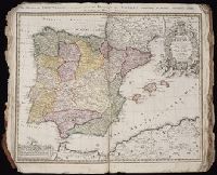
Beinecke Rare Book and Manuscript Library > Regnorum Hispaniae et Portugalliae tabula generalis de l'Isliana / aucta et ad usum scholarum novissime accom[m]odata a Ioh. Bapt. Homanno, , S.C.M. Geogr.
Creator:
Published / Created:
1728?
Call Number:
1973 Folio 30
Collection Title:
[Atlas factice of 32 maps and 1 distance table, produced by the Homann Erben firm]
Image Count:
3
Alternative Title:
Regnorum Hispaniae et Portugalliae tabula generalis de l’Isliana and Reyno de Espanna dividido en dos grandes estados de Aragon y de Castilla, subdividido en muchas provincias donde se halla tambien el Reyno de Portugal
Publisher:
[Homann Erben]
Subject (Geographic):
Portugal --Maps --Early works to 1800 and Spain --Maps --Early works to 1800
Subject (Topic):
Atlases, German --Early works to 1800
Collection Created:
[Nuremberg : s.n.,
Found in:
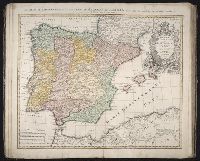
Beinecke Rare Book and Manuscript Library > Regnorvm Hispaniae et Portvgalliae tabula generalis de l'Isliana / [cartographic material] / aucta et ad usum scholarum novissime accom[m]odata a Ioh. Bapt. Homanno, S.C.M. Geogr.
Call Number:
Taylor 136
Collection Title:
La cosmographia, y geographia del S. Hieronimo Girava Tarragones : en la qual se contiene la
Image Count:
1
Description:
Map has several small holes along fold lines. and On verso: map has several small marks ranging from yellow to brown and gray.
Subject (Name):
Miranda, Giovanni de, 16th cent
Subject (Topic):
Discoveries in geography --Early works to 1800, Discoveries in geography --Spanish, Maps --Early works to 1800, and Maps in books --1570
Collection Created:
En Venetia : Por Iordan Zileti, y su companero,
Found in:
Beinecke Rare Book and Manuscript Library > Typo de la carta cosmographica de Gaspar Vopellio Medeburgense
Published / Created:
Undated
Call Number:
1978 595
Collection Title:
El atlas abreviado, o Compendiosa geografia, del mvndo antigvo, y nvevo, segun esta oy dividido
Image Count:
1
Resource Type:
Maps, Atlases & Globes
Description:
Imperfect: wormed with very slight loss of text. and Verso blank
Subject (Geographic):
British Isles --Maps --Early works to 1800
Subject (Name):
Laso, Francisco
Subject (Topic):
Atlases --Early works to 1800
Collection Created:
En Amberes: A costa de Francisco Laso, mercader de libros, enfrente de S. Phelipe el Real de Madrid, ano 1711
Found in:
Beinecke Rare Book and Manuscript Library > Yslas Britanicas enque se comprehenden los reynos de Ynglaterra, Escocia, e Yrlanda
Call Number:
Taylor 58
Collection Title:
Praeclara Ferdinadi. Cortesii de noua maris Oceani Hyspania narratio ... Carolo Romanoru imperatori
Image Count:
1
Description:
Preceding Argumentum Libri. and Teaching resource: Professor John Mack Faragher, History 141: The American West.
Subject (Geographic):
Mexico City (Mexico) and Mexico --History --Conquest, 1519-1540
Subject (Name):
Savorgnano, Pietro
Collection Created:
Norimberga, 1524
Found in:
Beinecke Rare Book and Manuscript Library > [Untitled map of Tenochtitlan]
Published / Created:
[Ca. 1612]
Call Number:
Taylor 258
Collection Title:
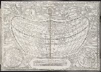
Descriptio ac delineatio geographica detectionis freti, sive, transitus ad occasum supra terras
Image Count:
1
Description:
Bound in after p. [8]., Map folded irregularly., Printed on recto in lower right corner: B., and Scale [ca. 1:160,000,000].
Subject (Name):
Quieros, Pedro Fernandes de, d. 1615
Subject (Topic):
World maps --Early works to 1800
Collection Created:
Amsterodami Ex officina Hesse lij Gerardi. Anno 1613
Found in:
Beinecke Rare Book and Manuscript Library > [World map]
Published / Created:
1606
Call Number:
Taylor 237
Collection Title:
Regimiento de navegacion mando hazer el rei nvestro senor por orden de sv conseio real de las
Image Count:
1
Description:
Right edge of map has been folded unevenly., Scale [ca. 1:141,000,000]., and Some place names appear inverted on map.
Subject (Name):
Garcia de Cespedes, Andres, d. 1611
Subject (Topic):
Navigation --Early works to 1800 and World maps --Early works to 1800
Collection Created:
Madrid, En casa de I. de la Cuesta, 1606
Found in:
Beinecke Rare Book and Manuscript Library > [World map]
Published / Created:
[Ca. 1612]
Call Number:
Pequot G325
Collection Title:
Descriptio ac delineatio geographica detectionis freti, sive, transitus ad occasum supra terras
Image Count:
1
Description:
Bound in after p. [8]., Printed on recto: "B" in lower right margin., and Scale [ca. 1:160,000,000].
Subject (Topic):
World maps --Early works to 1800
Collection Created:
Amsterodami Ex officina Hesse lij Gerardi. Anno 1613
Found in:
Beinecke Rare Book and Manuscript Library > [World map]
Branch:v1.61.8 ,Deployed:2024-06-20T11:15:15-04:00