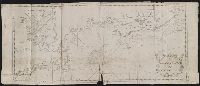
The English pilot: describing the West-India navigation, from Hudson's-Bay to the river Amazones
Image Count:
1
Subject (Geographic):
Atlantic Ocean --Maps --Early works to 1800, Boston Harbor (Mass.) --Maps --Early works to 1800, New England --Maps --Early works to 1800, and Nova Scotia --Maps --Early works to 1800
Subject (Topic):
Navigation --Early works to 1800, Pilot guides --Atlantic Coast (U.S.) --Early works to 1800, and Pilot guides --Caribbean Area --Early works to 1800
Collection Created:
London : Printed for W. and J. Mount, T. Page and son, on Tower-Hill, MDCCLX [1760]
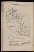
The English pilot: describing the West-India navigation, from Hudson's-Bay to the river Amazones
Image Count:
1
Subject (Geographic):
Atlantic Ocean --Maps --Early works to 1800, Boston (Mass.) --Maps --Early works to 1800, Boston Harbor (Mass.) --Maps --Early works to 1800, New England --Maps --Early works to 1800, New York (State) --Maps --Early works to 1800, and Rhode Island --Maps --Early works to 1800
Subject (Topic):
Navigation --Early works to 1800, Pilot guides --Atlantic Coast (U.S.) --Early works to 1800, and Pilot guides --Caribbean Area --Early works to 1800
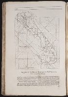
BEIN 2003 Folio 85: No. 7 of 45 maps bound together with binder's spine title: Atlas of America; ms. table of contents. Bookplate of Paul Mellon., Engraved by: Thomas Jefferys, geographer to his majesty., Hand-colored., Kershaw, Kenneth. Early printed maps of Canada, vol. 4, no. 1015., Map shows details of British and French positions during the siege of Quebec and table of references identifies British military units., Overlay provides details of changed position of British troops at the battle of September 13, 1759., Published in: A general topography of North America, London, 1768., and Scale 1:18,500.
Publisher:
Thos. Jefferys, the corner of St. Martins Lane Charing Cross
Subject (Geographic):
QueÌbec (QueÌbec) -- Maps -- Early works to 1800, QueÌbec Campaign, 1759 -- Maps, and United States -- History -- French and Indian War, 1755-1763 -- Maps
The generall historie of Virginia, New-England, and the Summer Isles : with the names of the
Image Count:
1
Abstract:
With inset map of "Ould Virginia" [with linen backing].
Description:
Engraved by Robert Vaughan, Ink washes on various vignettes., and Tipped-in facing title page.
Publisher:
Printed by I.D. and I.H. for Michael Sparkes
Subject (Name):
Smith, John, 1580-1631
Subject (Topic):
Indians of North America--Virginia., New England --History --Colonial period, ca. 1600-1775., Virginia --History --Colonial period, ca. 1600-1775, and Voyages and travels.
Collection Created:
London : Printed by I.[ohn] D.[awson] and I.[ohn] H.[aviland] for Michael Sparkes, 1624
The generall historie of Virginia, New-England, and the Summer Iles ...
Image Count:
1
Abstract:
Inset map of Virginia
Description:
Engraved by Robert Vaughan, Facing p. 41, and Printed by James Reeve
Publisher:
Printed by I.D. and I.H. for Michael Sparkes
Subject (Name):
Smith, John, 1580-1631
Subject (Topic):
Indians of North America--Virginia., New England --History --Colonial period, ca. 1600-1775., Virginia --History --Colonial period, ca. 1600-1775, and Voyages and travels.
Collection Created:
London : Printed by I.D. and I.H. for Michael Sparkes, 1624
Atlas minor: or a set of sixty-two new and correct maps, of all parts of the world. All composed
Image Count:
1
Description:
Autograph of Gravely. Autograph of Baldock. Autograph of Aston. Autograph of W. Alington. and Teaching resource: Professor John Mack Faragher, History 141: The American West.
Subject (Geographic):
America--Maps--Early works to 1800 and Fundy, Bay of--Maps