Skip to search
Skip to main content
Skip to first result
Search
You Searched For
Date
Unknown
Extent of Digitization
Partially digitized
Resource Type
Maps, Atlases & Globes
Date Created
[Missing]
New Search
Search Results
Creator:
Call Number:
1976 Folio 110
Collection Title:
The mariners mirrovr wherin may playnly be seen the courses, heights, distances, depths, sounding
Image Count:
1
Resource Type:
Maps, Atlases & Globes
Subject (Geographic):
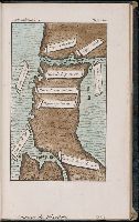
Dover (England), England, English Channel, and Isle of Wight (England)
Collection Created:
[London, J. Charlewood? 1588]
Found in:
Beinecke Rare Book and Manuscript Library > The sea coastes of England betweene the Ile of Wight & Douer, with the principal hauens thereof according to their situation and appearing
Creator:
Call Number:
1976 Folio 110
Collection Title:
The mariners mirrovr wherin may playnly be seen the courses, heights, distances, depths, sounding
Image Count:
1
Resource Type:
Maps, Atlases & Globes
Subject (Geographic):
Bristol Channel, England, and English Channel
Collection Created:
[London, J. Charlewood? 1588]
Found in:
Beinecke Rare Book and Manuscript Library > The sea coastes of England, from the Sorlinges by the landes end to Plymouth with the hauens and harbrowghes
Creator:
Call Number:
1976 Folio 110
Collection Title:
The mariners mirrovr wherin may playnly be seen the courses, heights, distances, depths, sounding
Image Count:
1
Resource Type:
Maps, Atlases & Globes
Subject (Geographic):
Portugal
Collection Created:
[London, J. Charlewood? 1588]
Found in:
Beinecke Rare Book and Manuscript Library > The sea coastes of Portugal betwene Camino & Montego eue as the countrie there aboutes is lying and situated with all the havens thereof exactly done, and corected with great dilligence
Creator:
Call Number:
1976 Folio 110
Collection Title:
The mariners mirrovr wherin may playnly be seen the courses, heights, distances, depths, sounding
Image Count:
1
Resource Type:
Maps, Atlases & Globes
Description:
Theodor de Bry, Sculp.
Subject (Geographic):
Bordeaux (France) and Garonne River (Spain and France)
Collection Created:
[London, J. Charlewood? 1588]
Found in:
Beinecke Rare Book and Manuscript Library > The sea coastes of the landes of Poyctou and Bordeaux ...as they shew and appeare, when you sayle there alongst betweene Picquelier and the River of Bordeaux called the Garonne
Call Number:
1973 Folio 114
Collection Title:
The English pilot: describing the West-India navigation, from Hudson's-Bay to the river Amazones
Image Count:
1
Resource Type:
Maps, Atlases & Globes
Subject (Geographic):
Atlantic Ocean --Maps --Early works to 1800, Maryland --Maps --Early works to 1800, New Jersey --Maps --Early works to 1800, and Virginia --Maps --Early works to 1800
Subject (Topic):
Navigation --Early works to 1800, Pilot guides --Atlantic Coast (U.S.) --Early works to 1800, and Pilot guides --Caribbean Area --Early works to 1800
Collection Created:
London : Printed for W. and J. Mount, T. Page and son, on Tower-Hill, MDCCLIX [1759]
Found in:
Beinecke Rare Book and Manuscript Library > Virginia, Maryland, Pennsilvania, east & west New Jarsey
Call Number:
1977 1341
Collection Title:
Geographiae vniversae opvs habentur Cl. Ptolemaei ... Geographicae enarationis libri octo [tr. by W
Image Count:
1
Resource Type:
Maps, Atlases & Globes
Subject (Topic):
Geography--Early works to 1800
Collection Created:
Venetiis : Apud Haeredes Simonis Galignani de Karera, 1596
Found in:
Beinecke Rare Book and Manuscript Library > Vniversi orbis descriptio ad vsvm navigantivm
Call Number:
Gfp94 gf525j
Collection Title:
Geographiae vniversae ... opvs ... habentur Cl. Ptolemaei ... Geographicae enarrationis libri octo
Image Count:
1
Resource Type:
Maps, Atlases & Globes
Subject (Topic):
Geography--Early works to 1800
Collection Created:
Venetiis : Apud Haeredes Simonis Galignani de Karera, 1596
Found in:
Beinecke Rare Book and Manuscript Library > Vniversi orbis descriptop as vsvm navigantivm
Call Number:
1972 515
Collection Title:
Premier voyage autour du monde / par le Chevr. Pigafetta, sur l'escadre de Magellan, pendant les
Image Count:
1
Resource Type:
Maps, Atlases & Globes
Collection Created:
A Paris :
Found in:
Beinecke Rare Book and Manuscript Library > Voyage de Pigafetta
Call Number:
Zc86 915yo
Collection Title:
Alaska days with John Muir / by S. Hall Young
Image Count:
1
Resource Type:
Maps, Atlases & Globes
Publisher:
C.S. Hammond & Co
Subject (Geographic):
Alaska--Description and travel
Collection Created:
New York : Fleming H. Revell Company c1915
Found in:
Beinecke Rare Book and Manuscript Library > Voyages of Muir and Young 1879 and 1880 in southeastern Alaska
Call Number:
1977 +392
Collection Title:
A survey of the cities of London and Westminster : containing the original, antiquity, increase
Image Count:
1
Resource Type:
Maps, Atlases & Globes
Description:
Plate between p. 150-151.
Subject (Geographic):
London (England)--History
Collection Created:
London : Printed for A. Churchill, J. Knapton, R. Knaplock, J. Walthoe [and 6 others], 1720
Found in:
Beinecke Rare Book and Manuscript Library > Walbrook Ward and Dow Gate Ward with its division into parishes taken from the last surveys
Branch:v1.61.6 ,Deployed:2024-06-12T09:55:36-04:00