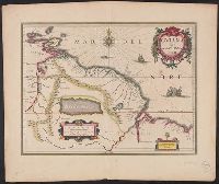
Gviana siue Amazonvm regio and Gviana sive Amazonvm regio
Description:
Cross Collection no. 337., From Willem Janszoon and Joan Blaeu's Theatrum orbis terrarum ... Amsterdami : Apud Ioh. & Cornelium Blaeu, 1640., Hand col., and In Latin on verso, with caption title "Guiana sive regio Amazonum" and signature P.
Publisher:
Guiljelmus Blaeuw excudit,
Subject (Geographic):
Guyana--Maps--Early works to 1800
Subject (Name):
Blaeu, Joan, 1596-1673. Theatrum orbis terrarum and Blaeu, Willem Janszoon, 1571-1638. Theatrum orbis terrarum
Blaeu, Joan, 1596-1673 Blaeu, Willem Janszoon, 1571-1638
Published / Created:
[ca. 1634]
Call Number:
1983 Folio 19
Collection Title:
[Atlas factice of 96 maps by Blaeu, Visscher, Jansson, Hondius and others]
Image Count:
1
Description:
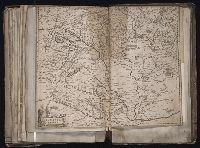
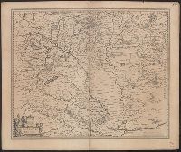
Imperfect: torn along fold, with some loss of text. Sheet measures 40.5 x 51.0 cm. Reinforced along edges with printed waste. No. 88 of 92 maps bound together. and Numbered 94 on verso.
Bar scale given in "milliaria Hungarica communia"., From Willem and Joan Blaeu's Theatrum orbis terrarum (1635)., Imperfect: sheet torn along fold, with some loss of text. Ms. no. on verso: j28. Sheet measures 48.0 x 57.3 cm., In La, and Relief shown pictorially.
Publisher:
Apud Guiljelmum et Johannem Blaeu,
Subject (Geographic):
Hungary--Maps--Early works to 1800
Subject (Name):
Blaeu, Joan, 1596-1673. Theatrum orbis terrarum and Blaeu, Willem Janszoon, 1571-1638. Theatrum orbis terrarum
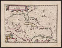
Insulae Americanae in Oceano Septentrionali cum terris adjacentibus and Insvlae Americanae in Oceano Septentrionali cum terris adiacentibus
Description:
Cf. Burden, P.D. Mapping of North America, 242., Cf. Koeman, C. Atlantes Neerlandici (1997 ed.), II, p. 600 (map 9600:2B)., Includes dedication to "D. Alberto Conradi Vander Burch" signed "tabulam hanc inscribit Guiljelmus Blaeu.", Includes embellished title cartouche, dedication with coats-of-arms, scale and ill. of ships at sea., and Includes scales in milliaria germanica and milliaria hispanica.
Publisher:
s.n.,
Subject (Geographic):
Caribbean Area--Maps--Early works to 1800, Mexico, Gulf of--Maps--Early works to 1800, and West Indies--Maps--Early works to 1800
Subject (Topic):
Coasts--North America--Maps--Early works to 1800 and Coasts--South America--Maps--Early works to 1800
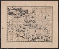
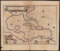
Insulae Americanae in Oceano Septentrionali cum terris adjacentibus
Description:
An unrecorded reduced version of Blaeu's map, where the cherub decorations on the cartouche and scale have been replaced by Native Americans, West Indians and Europeans. Coastlines vary sligh and Includes scales in milliaria germanica and milliaria hispanica.
Publisher:
s.n.,
Subject (Geographic):
Caribbean Area--Maps--Early works to 1800, Mexico, Gulf of--Maps--Early works to 1800, and West Indies--Maps--Early works to 1800
Subject (Topic):
Coasts--North America--Maps--Early works to 1800 and Coasts--South America--Maps--Early works to 1800
Insulae Americanae in Oceano Septentrionali cum terris adjacentibus and Insvlae Americanae in Oceano Septentrionali cum terris adiacentibus
Description:
From Willem Janszoon and Joan Blaeu's Theatrum orbis terrarum ... Amsterdami : Apud Guiljelmum et Iohannem Blaeu, 1635., Includes dedication to "D. Alberto Conradi Vander Burch" signed "tabulam hanc inscribit Guiljelmus Blaeu.", Includes embellished title cartouche, dedication with coats-of-arms, scale and ill. of ships at sea., and Includes scales in milliaria germanica and milliaria hispanica.
Publisher:
s.n.,
Subject (Geographic):
Caribbean Area--Maps--Early works to 1800, Mexico, Gulf of--Maps--Early works to 1800, and West Indies--Maps--Early works to 1800
Subject (Name):
Blaeu, Joan, 1596-1673. Theatrum orbis terrarum and Blaeu, Willem Janszoon, 1571-1638. Theatrum orbis terrarum
Subject (Topic):
Coasts--North America--Maps--Early works to 1800 and Coasts--South America--Maps--Early works to 1800
Insulae Americanae in Oceano Septentrionali cum terris adjacentibus and Insvlae Americanae in Oceano Septentrionali cum terris adiacentibus
Description:
Includes ded, Sheet measures 45.8 x 59.8 cm. Cross Collection no. 228., and Text in Latin on verso with caption title "Insulae americanae in oceano septemtrionali, ante sinum mexicanum, & aliquot continentis regiones," title at foot "America," and signature D3.
Publisher:
s.n.,
Subject (Geographic):
Caribbean Area--Maps--Early works to 1800, Mexico, Gulf of--Maps--Early works to 1800, and West Indies--Maps--Early works to 1800
Subject (Name):
Blaeu, Joan, 1596-1673. Theatrum orbis terrarum and Blaeu, Willem Janszoon, 1571-1638. Theatrum orbis terrarum
Subject (Topic):
Coasts--North America--Maps--Early works to 1800 and Coasts--South America--Maps--Early works to 1800