Relief shown pictorially., North oriented down., Bar scale given in unidenified units., Coordinates not present on map and are approximated., Includes index of colleges, buildings, and streets., and Insets: view of Oxforde and a map of Oxfordshire with bar scale in miles.
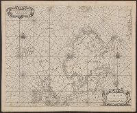
BEIN 21 1670A: Manuscript number on verso: 173. Watermark., Depths shown by isolines and soundings., Coordinates not present on map and are approximated., and From Blaeu's De groote Zee-spiegel (Amsterdam, 1655).
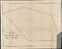
BEIN BrSides Folio 2014 10: Imperfect: torn and mutilated, with lower right corner missing., "Area 18 acres.", and Removed from: History of the city burial ground, in New Haven, together with the names of the owners of the lots therein (1863).
Publisher:
publisher not identified and Lith. by Punderson & Crisand
Title supplied by cataloger., Nineteenth century forgery of a portlan chart., Manuscript note in accompanying case: A manuscript portolan on vellum probably executed by a Spanish chartmaker circa 1550, the coasts outlined in green with place names in gothic letters of red and black, decorated with devices of the sun and moon in umber heightened with gold, 14 x 9 inches. This chart is a rare example from its unusally small size. RH. 7487., and Pen and ink wash color on parchment, in Italian, in unidentified hand.
BEIN Folio G1244 N48 S26 1973: Imperfect: sheets 351-352 wanting. Disbound., Title from accompanying letter., Unpublished. Available upon request at the Sanborn Map Company, Inc., Also referred to by Publisher as Atlas of New Haven, Connecticut., and Contains information on population, prevailing winds, water facilities and fire department.
BEIN BrSides Zc35 908un: Holes punched in margins.
Publisher:
Dept. of the Interior, General Land Office, Andrew B. Graham Co.)
Subject (Geographic):
Cheyenne River Indian Reservation (S.D.), Standing Rock Indian Reservation (N.D. and S.D.), South Dakota, Cheyenne River Indian Reservation., United States, and Standing Rock Indian Reservation.
Peutinger table and Tabvla itineraria ex illvstri Pevtingerorvm Bibliotheca
Description:
BEIN 2016 +333: Imperfect: title panel mutilated, with some loss of text. Sheets joined together to form a roll; backed in linen., Relief shown pictorially., "MD" in publication date in apostrophic forms., Appears in Ortelius' Theatri Orbis Terrarum Parergon. Antwerp, 1624., and "Peutinger Table: Road map of Western Roman Empire about 250 A.D. bought by Conrad Peutinger and published in Venice by Aldus in 1591 (2 sections only), in Antwerp 1598 (12 sections) ... The only record of Roman map making that has survived to the present day."--Tooley's Dictionary of Mapmakers. New York, 1979.
Bankoku ichiranzu, Bankoku ichiran zusetsu, and (Explanation of the visualized map of all the countries)
Description:
BEIN 2018 +512: Manuscript annotations in English on margins of map., Cover attached; cover and map title the same., Accompanied by: BANKOKU ICHIRAN ZUSETSU : (Explanation of the visualized map of all the countries) / Koyano Yoshiharu. -- Bunka 7 : (1810). -- 2 v., ill. ; 25.2 x 18 cm., Kôzanrō is a private school of Koyano Yoshiharu., and California shown as an island.
Publisher:
Kôzanrô, (June, 1809)
Subject (Geographic):
Japan and Japan.
Subject (Topic):
World maps, Geography, Study and teaching, and Prints, Japanese
Twentieth century forgery of a portlan chart with seaport names given for all coastlines; based on chart from the circle of Vesconte Maggiolo., Title devised by cataloger., Pen-and-ink in gold, brown, red, blue, and green., Contains eight compass roses., Decoration: armorial shields, city views with gilded banners, tents, and Madonna with child., Pasted on wood backing with modern brocade edging., and Coordinates not present on map and are approximated.
Subject (Geographic):
Mediterranean Sea, North Atlantic Ocean, Black Sea, Africa, West, Mediterranean Sea., North Atlantic Ocean., Black Sea., and Africa, West.