Skip to search
Skip to main content
Skip to first result
Search
You Searched For
Repository
Beinecke Rare Book and Manuscript Library
Genre
Maps
New Search
Search Results
Published / Created:
1876
Call Number:
425 H676 1876
Container / Volume:
BRBL_00246
Image Count:
2
Resource Type:
Maps, Atlases & Globes
Description:
Title supplied by cataloger.
Publisher:
[K.u.k. militär-geographischen Institut],
Subject (Geographic):
Austria--Maps
Found in:
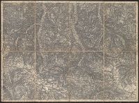
Beinecke Rare Book and Manuscript Library > [Specialkarte des österr. Alpengebietes 1:75.000.] Zone 17 Col. VIII, Hof-Gastein.
Published / Created:
[1890?]
Call Number:
32 R119 1890
Container / Volume:
BRBL_00054
Image Count:
1
Resource Type:
Maps, Atlases & Globes
Subject (Geographic):
Berkshire (England)--Maps
Found in:
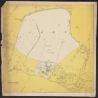
Beinecke Rare Book and Manuscript Library > [St. Peter's College] Radley Bounds [Berkshire].
Published / Created:
[1780?]
Call Number:
38 ST81 1780
Container / Volume:
BRBL_00165
Image Count:
1
Resource Type:
Maps, Atlases & Globes
Subject (Geographic):
Strasbourg (France)--Maps--Early works to 1800
Found in:
Beinecke Rare Book and Manuscript Library > [Strasbourg and Environs].
Published / Created:
c1949.
Call Number:
846 P837 1949A
Container / Volume:
BRBL_00622
Image Count:
4
Resource Type:
Maps, Atlases & Globes
Alternative Title:
North east districts, Portland., North-northwest district, Portland., S.E. district Portland., and S.W. district Portland.
Description:
Copyright: Henry R. Staats., Indexed., Sheets of map separately titled: North-northwest district, Portland -- North east districts, Portland -- S.W. district Portland -- S.E. district Portland., and Title devised by cataloger.
Publisher:
Henry R. Staats?],
Subject (Geographic):
Portland (Or.)--Maps
Subject (Name):
Staats, Henry R
Subject (Topic):
Streets--Oregon--Portland--Maps
Found in:
Beinecke Rare Book and Manuscript Library > [Street map of Portland, Or.].
Creator:
Published / Created:
[1962]
Call Number:
2008 1369
Image Count:
9
Alternative Title:
Theses on the Commune / by Debord, Kotanyi & Vaneigem
Publisher:
Libertaria Bookshop
Subject (Geographic):
Paris (France) --History --Commune, 1871
Subject (Name):
Internationale situationniste, Kotanyi, Attila, Libertaria Bookshop, and Vaneigem, Raoul, 1934-
Subject (Topic):
Radicalism
Found in:
Beinecke Rare Book and Manuscript Library > [Sur la Commune. English]
Published / Created:
1820?]
Call Number:
37 1820A
Image Count:
2
Resource Type:
Maps, Atlases & Globes
Description:
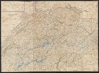
5 insets in border.
Publisher:
Heinrich Keller,
Subject (Geographic):
Switzerland--Maps
Found in:
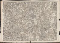
Beinecke Rare Book and Manuscript Library > [Switzerland]
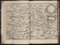
Published / Created:
MDXCVIII [1598]
Call Number:
Taylor 193 1-2
Collection Title:
Regnum Congo hoc est vera descriptio regni Africani : quod tam ab incolis quam Lusitanis Congus
Image Count:
1
Description:
Map has two identical small holes on both the top left and top right corners. and Third of three maps bound following leaf [4] of preface, continued from previous leaves.
Subject (Geographic):
Africa --Description and travel and Ethiopia
Collection Created:
Francofurti : Excudebat VVolffgangus Richter, impensis Io. Theo. & Io. Israel. de Bry, frat., MDXCVIII [1598]
Found in:
Beinecke Rare Book and Manuscript Library > [Tabulam hanc Aegypti ... sheet 2]
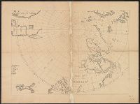
Published / Created:
[1650?]
Call Number:
18 1650
Container / Volume:
BRBL_00012
Image Count:
1
Resource Type:
Maps, Atlases & Globes
Subject (Geographic):
Arctic Regions--Maps--Early works to 1800
Found in:
Beinecke Rare Book and Manuscript Library > [The Arctic Regions].
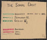
Published / Created:
1916
Call Number:
11hc 1916
Container / Volume:
BRBL_00010C
Image Count:
1
Resource Type:
Maps, Atlases & Globes
Description:
Shows the location of battle lines dated "before July 1, 1916" and "September 15", "October 15", railways, canals, roads, wooded areas, and towns.
Publisher:
s.n.,
Subject (Geographic):
Somme (France)--Maps
Found in:
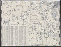
Beinecke Rare Book and Manuscript Library > [The Somme Drive.]
Published / Created:
1918.]
Call Number:
11hc 1917L
Container / Volume:
BRBL_00010D
Image Count:
1
Resource Type:
Maps, Atlases & Globes
Description:
"Situation map" stamped in lower right corner., Red lines indicate fluctuating location of the Western Front, with dates of "March 21" through "March 31", year unspecified., and Shows Amiens to the west and St. Quentin to the east.
Publisher:
G.2.C.,
Subject (Geographic):
Europe--Maps
Found in:
Beinecke Rare Book and Manuscript Library > [The Western front Situation Map.]
Branch:v1.61.8 ,Deployed:2024-06-20T11:14:55-04:00