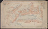
Port Valdez District, Prince William Sound region, Port Valdez District, and Topography, Alaska, Prince William Sound region, Port Valdez District
Description:
"Alaska Sheet no. 602 B.", "Control by Coast and Geodetic Survey. Surveyed in 1911 and 1912.", "Entire area within Chugach National Forest.", Includes index to the mines and prospects in the area and location map., Relief shown by contours and spot heights., and Title, upper center margin: Topography.
Publisher:
The Survey,
Subject (Geographic):
Port Valdez Region (Alaska)--Maps and Prince William Sound Region (Alaska)--Maps
Douglas, Edward Morehouse, 1855-1932, Gannett, Henry, 1846-1914, Hague, A. (Arnold), 1840-1917, Iddings, Joseph Paxson, 1857-1920, Leffingwell, W. H, Northern Transcontinental Survey, and Rensh
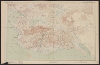
In two sheets., Includes inset of The Hawaiian Islands., and Relief shown by contours and spot heights; contour interval 40 ft.
Publisher:
Dept. of the Interior, U.S. Geological Survey,
Subject (Geographic):
Hawaii--Oahu and Oahu (Hawaii)--Maps
Subject (Name):
Birdseye, C. H. (Claude Hale), 1878-1941, Davis, Geo. R. (George R.), Fowler, A. T, Hawaii. Territorial Survey., Marshall, R. B. (Robert Bradford), 1867-1949, and U.S. Coast and Geodetic Survey