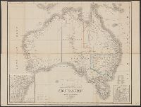
Geographisches Institut (Weimar, Thuringia, Germany) Kiepert, Heinrich, 1818-1899 Weiland, C. F. (Carl Ferdinand), -1847, cartographer
Published / Created:
[1855?]
Call Number:
26 1855
Container / Volume:
BRBL_00022
Image Count:
1
Resource Type:
Maps, Atlases & Globes
Description:
Hand col. Sheet measures 50 x 64.5 cm., In German., Insets: [1.] Neu Süd Wales -- [2.] Colonie Süd-Australia., Prime meridians: Ferro, Greenwich and Paris., and Top right-hand corner: "67".
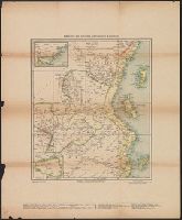
Geographisches Institut (Weimar, Thuringia, Germany) Reinecke, J. C. M. (Johann Christoph Matthias), 1770-1818
Published / Created:
1804
Call Number:
649 1804
Container / Volume:
BRBL_00340
Image Count:
1
Resource Type:
Maps, Atlases & Globes
Description:
Covers Central Africa from Angola in the south to Mozambique, Zambia, and Congo in the north., In right margin: "An dieses Blatt schliesst sich die Charte von der Kafferkuste.", and Relief shown by hachures.
"Revidierter Ausschnitt aus Kettler's Spezialkarte von Deutschostafrika.", Insets: [Deutsch Witu Land] -- Süd-Hessen im gleichen Massstabe., and Relief shown by shading.
Publisher:
Geographisches Institut,
Subject (Geographic):
Germany--Colonies--Africa--Administration--Maps and Tanzania--Maps