Skip to search
Skip to main content
Skip to first result
Search
You Searched For
Creator
A. & W. Mackinlay (Firm)
New Search
Search Results
Creator:
Published / Created:
1865
Call Number:
732 1865
Container / Volume:
BRBL_00376A
Image Count:
1
Resource Type:
Maps, Atlases & Globes
Alternative Title:
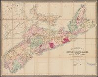
Mackinlay's map and history of Nova Scotia
Description:
Relief shown by hachures. and Shows settlements, roads, railroads, telegraph lines, gold districts, coal mining areas, post offices, ports of entry, telegraph stations, etc.
Publisher:
A & W. Mackinlay,
Subject (Geographic):
Nova Scotia--Maps and Prince Edward Island--Maps
Subject (Name):
George Philip & Son and Hendry, W. A
Found in:
Beinecke Rare Book and Manuscript Library > Mackinlay's map of the province of Nova Scotia, including the island of Cape Breton : compiled from actual & recent surveys / drawn by W.A. Hendry ; engraved by G. Philip & Son, Liverpool.
Creator:
Published / Created:
1899
Call Number:
7325 1899
Container / Volume:
BRBL_00376A
Image Count:
1
Resource Type:
Maps, Atlases & Globes
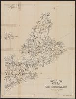
Alternative Title:
Mackinlay's map of Cape Breton Island and New map of Cape Breton
Description:
Covers also Prince Edward Island and Amherst. and Relief shown by hachures.
Publisher:
A. & W. Mackinlay,
Subject (Geographic):
Cape Breton Island (N.S.)--Maps
Subject (Name):
George Philip & Son
Found in:
Beinecke Rare Book and Manuscript Library > Mackinlay's new map of Cape Breton Island : compiled from recent surveys.
Branch:v1.61.6 ,Deployed:2024-06-12T09:55:33-04:00