Skip to search
Skip to main content
Skip to first result
Search
You Searched For
Extent of Digitization
Completely digitized
Genre
Topographic maps
Language
German
New Search
Search Results
Creator:
Published / Created:
[1876]
Call Number:
BrSides Folio 2019 105
Image Count:
10
Resource Type:
Maps, Atlases & Globes
Description:
Dissected and mounted on linen. Labels with sheet titles in manuscript on verso. Includes additional "Ausg. 1877" for southernmost sheet ("Lussina u. Osero")., Fasine & Canale della Morlacca -- Cherso u. Canale dell' Arsa -- Osero u. Lussina -- Pola., and Relief shown by hachures.
Publisher:
[K.K. Militaerisch-Geografischen Institute],
Subject (Geographic):
Hungary--Maps.
Found in:
Beinecke Rare Book and Manuscript Library > [Special-Karte des Königreichs Ungarn].
Published / Created:
1864
Call Number:
37 1907B
Container / Volume:
BRBL_00149
Image Count:
1
Resource Type:
Maps, Atlases & Globes
Description:
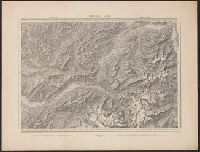
"Blatt XLII", "Interlachen", "Sarnen Stanz".
Publisher:
Swiss Government],
Subject (Geographic):
Switzerland--Maps
Found in:
Beinecke Rare Book and Manuscript Library > [Switzerland] / G.H. Dufour direxit; H. Müllhaupt sculpsit.
Branch:v1.61.8 ,Deployed:2024-06-20T11:15:04-04:00