Skip to search
Skip to main content
Skip to first result
Search
You Searched For
Extent of Digitization
Completely digitized
Resource Type
Maps, Atlases & Globes
Language
German
New Search
Search Results
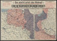
Published / Created:
191-.
Call Number:
11hc 1915R
Container / Volume:
BRBL_00010C
Image Count:
2
Resource Type:
Maps, Atlases & Globes
Description:
Includes 2 maps, text, and ill. and On verso: 4 anciallry maps, text, and ill.
Publisher:
Julius Hans Forkel,
Subject (Geographic):
Germany--Maps
Subject (Topic):
World War, 1914-1918--Maps
Found in:
Beinecke Rare Book and Manuscript Library > [So steht jetzt der Krieg!] : Kriegsoperationskarte über alle Kriegsschauplätze der welt.
Creator:
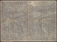
Published / Created:
[1876]
Call Number:
BrSides Folio 2019 105
Image Count:
10
Resource Type:
Maps, Atlases & Globes
Description:
Dissected and mounted on linen. Labels with sheet titles in manuscript on verso. Includes additional "Ausg. 1877" for southernmost sheet ("Lussina u. Osero")., Fasine & Canale della Morlacca -- Cherso u. Canale dell' Arsa -- Osero u. Lussina -- Pola., and Relief shown by hachures.
Publisher:
[K.K. Militaerisch-Geografischen Institute],
Subject (Geographic):
Hungary--Maps.
Found in:
Beinecke Rare Book and Manuscript Library > [Special-Karte des Königreichs Ungarn].
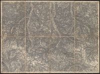
Published / Created:
1877
Call Number:
425 R119 1877
Container / Volume:
BRBL_00246
Image Count:
2
Resource Type:
Maps, Atlases & Globes
Description:
Title supplied by cataloger.
Publisher:
[K.u.k. militär-geographischen Institut],
Subject (Geographic):
Austria--Maps
Found in:
Beinecke Rare Book and Manuscript Library > [Specialkarte des österr. Alpengebietes 1:75.000.] Zone 16 Col. IX, Radstadt.
Published / Created:
1876
Call Number:
425 H676 1876
Container / Volume:
BRBL_00246
Image Count:
2
Resource Type:
Maps, Atlases & Globes
Description:
Title supplied by cataloger.
Publisher:
[K.u.k. militär-geographischen Institut],
Subject (Geographic):
Austria--Maps
Found in:
Beinecke Rare Book and Manuscript Library > [Specialkarte des österr. Alpengebietes 1:75.000.] Zone 17 Col. VIII, Hof-Gastein.
Published / Created:
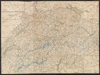
1820?]
Call Number:
37 1820A
Image Count:
2
Resource Type:
Maps, Atlases & Globes
Description:
5 insets in border.
Publisher:
Heinrich Keller,
Subject (Geographic):
Switzerland--Maps
Found in:
Beinecke Rare Book and Manuscript Library > [Switzerland]
Published / Created:
1864
Call Number:
37 1907B
Container / Volume:
BRBL_00149
Image Count:
1
Resource Type:
Maps, Atlases & Globes
Description:
"Blatt XLII", "Interlachen", "Sarnen Stanz".
Publisher:
Swiss Government],
Subject (Geographic):
Switzerland--Maps
Found in:
Beinecke Rare Book and Manuscript Library > [Switzerland] / G.H. Dufour direxit; H. Müllhaupt sculpsit.
Published / Created:
[1940?]
Call Number:
456 1918
Container / Volume:
BRBL_00259
Image Count:
1
Resource Type:
Maps, Atlases & Globes
Description:
Red lines connecting some towns printed over base map.
Publisher:
Kgl. Ung. Staatl. Kartographischen Institutes,
Subject (Geographic):
Transylvania (Romania)--Maps
Found in:
Beinecke Rare Book and Manuscript Library > [Transylvania] / Entworfen von Robert Csallner.
Published / Created:
[1940?]
Call Number:
456 1918A
Container / Volume:
BRBL_00259
Image Count:
1
Resource Type:
Maps, Atlases & Globes
Description:
Red lines connecting some towns printed over base map. and Relief shown by shading.
Publisher:
Kgl. Ung. Staatl. Kartographischen Institutes,
Subject (Geographic):
Transylvania (Romania)--Maps
Found in:
Beinecke Rare Book and Manuscript Library > [Transylvania] / Entworfen von Robert Csallner.
Published / Created:
[1940?]
Call Number:
456 1940A
Container / Volume:
BRBL_00259
Image Count:
1
Resource Type:
Maps, Atlases & Globes
Description:
In lower left corner: "M.224/935L." and Relief shown by shading.
Publisher:
Kgl. Ung. Staatl. Kartographischen Institutes,
Subject (Geographic):
Transylvania (Romania)--Maps
Found in:
Beinecke Rare Book and Manuscript Library > [Transylvania] / Entworfen von Robert Csallner.
Published / Created:
1823
Call Number:
89 1823
Container / Volume:
BRBL_00657
Image Count:
1
Resource Type:
Maps, Atlases & Globes
Description:
Texts on borders of map.
Publisher:
Geographisches Institut,
Subject (Geographic):
Central America--Maps
Found in:
Beinecke Rare Book and Manuscript Library > geographisch-statistische charte von Guatemala.
Branch:v1.61.8 ,Deployed:2024-06-20T11:15:02-04:00