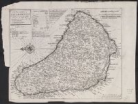
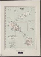
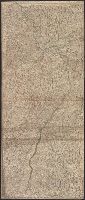
Cross Collection no. 307., From Herman Moll's Atlas minor. ... London : Thomas Bowles and John Bowles, [1736]., Includes table of are, Relief shown pictorially., and Shows churches, forts, plantations, windmills, submerged rocks, etc.
Publisher:
Printed and sold by Tho. Bowles, next ye Chapter House in St. Pauls Church yard & I. Bowles at the Black Horse in Cornhill,
Subject (Geographic):
Barbados--Maps--Early works to 1800
Subject (Name):
Bowles, John, 1701-1779, printer, Bowles, Thomas, -1767, printer, and Moll, Herman, -1732. Atlas minor
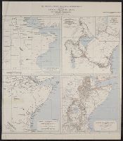
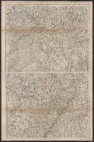
Maps of Eastern Equatorial Africa showing the progress of exploration
Description:
"Eastern Equatorial Africa, Garstin. The Geographical Journal, 1909"--in upper right hand corner. and Eastern Equatorial Africa according to Ptolemy, A.D. 150 -- Eastern Equatorial Africa immediately before Speke's first journey ... 1856 -- Map showing the results of Burton, Speke, and Grant's explorations ... 1863 -- Eastern Equatorial Africa, 1909.
Publisher:
Royal Geographical Society,
Subject (Geographic):
Africa, East--Discovery and exploration--Maps
Subject (Name):
Royal Geographical Society (Great Britain) and Speke, John Hanning,--1827-1864--Travel--Maps
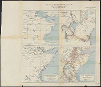
Maps of Eastern Equatorial Africa showing the progress of exploration
Description:
"Eastern Equatorial Africa, Garstin. The Geographical Journal, 1909"--in upper right hand corner. and Eastern Equatorial Africa according to Ptolemy, A.D. 150 -- Eastern Equatorial Africa immediately before Speke's first journey ... 1856 -- Map showing the re
Publisher:
Royal Geographical Society,
Subject (Geographic):
Africa, East--Discovery and exploration--Maps
Subject (Name):
Royal Geographical Society (Great Britain) and Speke, John Hanning,--1827-1864--Travel--Maps
From Thomas Stackhouse's New history of the Holy Bible (London, 1752)., In lower left corner, "Pl. 3"; in lower right corner, "page 24.", Prime meridian: Ferro., Relief shown pictorially., and Watermark.
Publisher:
[Printed for John Hinton],
Subject (Geographic):
Middle East--Historical geography--Maps--Early works to 1800. and Middle East--Maps--Early works to 1800.
Subject (Name):
Hinton, John, -1781 and Stackhouse, Thomas, approximately 1680-1752. New history of the Holy Bible.
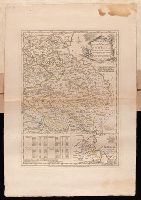
Plan of the country where the Prussian army gained a victory over the Austrians, Oct. 1, 1756. and Routes of the Prussian Armies into Bohemia
Description:
Bar scales given in "English miles 69 1/2 to a degree," "German miles 15 in a degree," and "Bohemian or gr ms. of Silesia 12 in a Deg.", Prime meridians: London and Ferro., Sheet measures 50.3 x 34.6 cm. No. 14 of 34 maps bound together., and With inset map: Plan of the country where the Prussian army gained a victory over the Austrians, Oct. 1, 1756.
Publisher:
T. Jeffreys,
Subject (Geographic):
Bohemia (Czech Republic)--Maps--Early works to 1800
Subject (Topic):
Seven Years' War, 1756-1763--Maps--Early works to 1800