Skip to search
Skip to main content
Skip to first result
Search
You Searched For
Date
Unknown
Genre
Maps in books
Resource Type
Maps, Atlases & Globes
Date Created
[Missing]
New Search
Search Results
Call Number:
1977 +392
Collection Title:
A survey of the cities of London and Westminster : containing the original, antiquity, increase
Image Count:
1
Resource Type:
Maps, Atlases & Globes
Description:
Plate between p. 90-91.
Subject (Geographic):
London (England)--History
Collection Created:
London : Printed for A. Churchill, J. Knapton, R. Knaplock, J. Walthoe [and 6 others], 1720
Found in:
Beinecke Rare Book and Manuscript Library > Bishop Gate Street Ward taken from the last survey and corrected
Creator:
Call Number:
1977 Folio 114
Collection Title:
L’atlas curieux ou Le monde represente dans des cartes generales et particulieres du ciel et de la
Image Count:
1
Resource Type:
Maps, Atlases & Globes
Description:
Verso blank.
Subject (Geographic):
Fontainebleau (France)
Subject (Topic):
Atlases, French
Collection Created:
A Paris, Chez l’auteur dans l’Isle du Palais sur le quay de l’Orloge a la Sphere Royale, 1700[-03]
Found in:
Beinecke Rare Book and Manuscript Library > Bourg, chateau, et iardins de Fontaine-bleau
Call Number:
1977 +392
Collection Title:
A survey of the cities of London and Westminster : containing the original, antiquity, increase
Image Count:
1
Resource Type:
Maps, Atlases & Globes
Description:
Plate between p. 14-15.
Subject (Geographic):
London (England)--History
Collection Created:
London : Printed for A. Churchill, J. Knapton, R. Knaplock, J. Walthoe [and 6 others], 1720
Found in:
Beinecke Rare Book and Manuscript Library > Bread Street Ward and Cordwainer Ward with it's division into parishes taken from the last survey
Call Number:
1977 +392
Collection Title:
A survey of the cities of London and Westminster : containing the original, antiquity, increase
Image Count:
1
Resource Type:
Maps, Atlases & Globes
Description:
Plate between p. 150-151.
Subject (Geographic):
London (England)--History
Collection Created:
London : Printed for A. Churchill, J. Knapton, R. Knaplock, J. Walthoe [and 6 others], 1720
Found in:
Beinecke Rare Book and Manuscript Library > Candlewick Ward with its division into parishes. Corrected from the last survey
Published / Created:
undated
Call Number:
Folio Q115 H84 1B
Collection Title:
Atlas geographique et physique des regions equinoxiales du nouveau continent, fonde sur des
Image Count:
1
Resource Type:
Maps, Atlases & Globes
Description:
At foot: Dessine par E.H. Michaelis, d'apres les croquis de Mr. de Humboldt. / Grave a Paris par Pierre Tardieu fils, Place de l'Estrapade No. 34. / l'Ecriture par L. Aubert pere. and Scale included
Subject (Geographic):
Magdalena River (Columbia) and South America
Subject (Topic):
Discoveries in geography, Explorers, Scientific expeditions, and Voyages and travels
Collection Created:
Paris : F. Schoell, 1814
Found in:
Beinecke Rare Book and Manuscript Library > Carte du Rio Grande de la Magdalena depuis le 4 [degrees] Latitude jusqu'a son embouchure. No. 24
Call Number:
1973 Folio 114
Collection Title:
The English pilot: describing the West-India navigation, from Hudson's-Bay to the river Amazones
Image Count:
1
Resource Type:
Maps, Atlases & Globes
Subject (Geographic):
Atlantic Ocean --Maps --Early works to 1800 and Newfoundland and Labrador --Maps --Early works to 1800
Subject (Topic):
Navigation --Early works to 1800, Pilot guides --Atlantic Coast (U.S.) --Early works to 1800, and Pilot guides --Caribbean Area --Early works to 1800
Collection Created:
London : Printed for W. and J. Mount, T. Page and son, on Tower-Hill, MDCCLIX [1759]
Found in:
Beinecke Rare Book and Manuscript Library > Cattalina Harbor
Creator:
Call Number:
1978 Folio 106
Collection Title:
Maps of the Orinoco-Essequibo region, South America. Compiled for the Commission appointed by the
Image Count:
1
Resource Type:
Maps, Atlases & Globes
Description:
Captions in German and English.
Subject (Geographic):
Guyana --Maps and Orinoco River Valley (Venezuela and Colombia)
Collection Created:
Washington, 1897
Found in:
Beinecke Rare Book and Manuscript Library > Chart of Guiana by Sir Walter Raleigh, [1595?]
Call Number:
1977 +392
Collection Title:
A survey of the cities of London and Westminster : containing the original, antiquity, increase
Image Count:
1
Resource Type:
Maps, Atlases & Globes
Description:
Plate between p. 26-27.
Subject (Geographic):
London (England)--History
Collection Created:
London : Printed for A. Churchill, J. Knapton, R. Knaplock, J. Walthoe [and 6 others], 1720
Found in:
Beinecke Rare Book and Manuscript Library > Cheape Ward with its division into parishes, taken from the last survey, with corrections and additions
Published / Created:
Undated
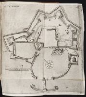
Call Number:
1973 845
Collection Title:
Navtica mediterranea / di Bartolomeo Crescentio Romano ... Nella quale si mostra la fabrica delle
Image Count:
1
Resource Type:
Maps, Atlases & Globes
Description:
Includes bar scale labeled "canne"., Map bound in after p. 535., Negative image of the number 537 can be seen just to the right of the printed number 537 as noted above., and Printed in upper right corner: 537.
Subject (Geographic):
Civitavecchia (Italy) --Maps --Early works to 1800
Collection Created:
Roma : Appresso Bartolomeo Bonfadino, 1607
Found in:
Beinecke Rare Book and Manuscript Library > Civita Vecchia
Call Number:
1977 +392
Collection Title:
A survey of the cities of London and Westminster : containing the original, antiquity, increase
Image Count:
1
Resource Type:
Maps, Atlases & Globes
Description:
Plate between p. 52-53.
Subject (Geographic):
London (England)--History
Collection Created:
London : Printed for A. Churchill, J. Knapton, R. Knaplock, J. Walthoe [and 6 others], 1720
Found in:
Beinecke Rare Book and Manuscript Library > Coleman Street Ward and Bashishaw Ward taken from the last survey, with corrections and additions
Branch:v1.61.8 ,Deployed:2024-06-20T11:15:02-04:00