Advertisements on verso., Indexed., Relief shown by hachures and spot heights., and Shows roads with indication of road surface, towns, national forests, and natural features.
Bookplate: ex libris T W S [i.e. Thomas Winthrop Streeter]. and Relief shown by hachures.
Publisher:
Chicago Lithographing Co.,
Subject (Name):
Chicago Lithographing Co, Denver Pacific Railway and Telegraph Company, Denver Pacific Railway and Telegraph Company--Maps, and Streeter, Thomas W.--(Thomas Winthrop),--1883-1965--Bookplate
Colton, G. Woolworth (George Woolworth), 1827-1901
Published / Created:
1862, c1861.
Call Number:
75 1862C
Container / Volume:
BRBL_00403
Image Count:
1
Resource Type:
Maps, Atlases & Globes
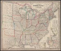
Alternative Title:
Guide map of the United States & Canada. and New Guide map of the United States & Canada.
Description:
Insets: Plan of the southern portion of Florida.--Western portion of the United States., Prime meridians: Greenwich, Washington., Relief shown by hachures., and Table: Population of the United States.
Hunting and fishing resorts of northwestern Wisconsin
Description:
"287" in bottom right margin., Includes wagon roads and trails as well as rail lines., and Verso: Hunting and fishing resorts of northern Wisconsin and Michigan, reached by the Chicago and North Western Railway. Copyright 1914 by Rand McNally & Co. Chicago.