Skip to search
Skip to main content
Skip to first result
Search
You Searched For
Extent of Digitization
Completely digitized
Format
cartographic
Creator
United States. Office of Strategic Services
Publication Place
[Washington, D.C.] :
New Search
Search Results
Creator:
Published / Created:
1943
Call Number:
36gma 1943
Container / Volume:
BRBL_00130
Image Count:
1
Resource Type:
Maps, Atlases & Globes
Description:
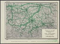
"Map no. 1994, 25 August 1943." and 1. Northwestern waterways -- 2. Berlin -- 3. Magdeburg.
Publisher:
Lithographed in the Reproduction Branch, OSS,
Subject (Geographic):
Europe, Central--Maps and Germany--Maps
Subject (Topic):
Inland navigation--Europe, Central--Maps and Inland navigation--Germany--Maps
Found in:
Beinecke Rare Book and Manuscript Library > "Greater Germany" inland waterways.
Creator:
Published / Created:
1945
Call Number:
36cb 1945
Container / Volume:
BRBL_00127
Image Count:
1
Resource Type:
Maps, Atlases & Globes
Description:
"No. 6339." and Shows cave regions within the "Greater" German boundary of 1944.
Publisher:
OSS,
Subject (Geographic):
Europe, Central--Maps
Subject (Topic):
Caves--Europe, Central--Maps
Found in:
Beinecke Rare Book and Manuscript Library > "Greater" Germany caves and cave regions.
Creator:
Published / Created:
1944
Call Number:
57gm T578 1944A
Container / Volume:
BRBL_00307
Image Count:
1
Resource Type:
Maps, Atlases & Globes
Description:
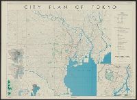
"17 October 1944.", "Base map: "Map of greater Tōkyō," published by Tōkyō Geographical Association, Jan. 15 1936.", "Lithographed in the reproduction branch, OSS.", "No. 5279--R & A, OSS.", and Includes 5 inset maps, and text.
Publisher:
OSS,
Subject (Geographic):
Tokyo (Japan)--Maps and Tokyo Metropolitan Area (Japan)--Maps
Found in:
Beinecke Rare Book and Manuscript Library > City plan of Tōkyō.
Creator:
Published / Created:
1943
Call Number:
38gma 1943
Container / Volume:
BRBL_00170
Image Count:
1
Resource Type:
Maps, Atlases & Globes
Description:
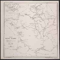
"No. 683.", Includes inset northern regions., and Includes legend on sheet.
Publisher:
O.S.S.,
Subject (Geographic):
France--Maps
Subject (Topic):
Waterways--France--Maps
Found in:
Beinecke Rare Book and Manuscript Library > France Navigable Waterways [cartographic material].
Branch:v1.61.6 ,Deployed:2024-06-12T09:55:19-04:00