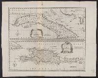
New & accurate map of the islands of Hispaniola or St. Domingo, and Porto Rico, New and accurate map of the island of Cuba, and New and accurate map of the islands of Hispaniola or St. Domingo, and Porto Rico
Description:
"No. 80.", Bar scale in English miles., From Bowen's A complete system of geography?, Relief shown pictorially., and Sheet measures 41.3 x 51.6 cm.
Publisher:
s.n.,
Subject (Geographic):
Cuba--Maps--Early works to 1800, Hispaniola--Maps--Early works to 1800, and Puerto Rico--Maps--Early works to 1800
Subject (Name):
Bowen, Emanuel, d. 1767. Complete system of geography
"W. long. from London.", From the Universal magazine (June 1780), v. 66., Mounted on linen. Sheet measures 31.9 x 27 cm. Cross Collection no. 203., Relief shown pictorially., and Title within ornamental cartouche.
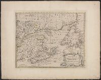
A new & accurate map of the Islands of Newfoundland, Cape Breton, St. John and Anticosta, Newfoundland, Cape Breton, St. John and Anticosta [cartographic material], and The Islands of Newfoundland, Cape Breton, St. John and Anticosta [cartographic material]
Description:
"No. 95" -- in lower right margin., Co, Hand col. Ms. note on verso: Appears as No. 63 in Bowen, E. Complete atlas, etc. London, 1752., London meridian., Relief shown pictorially., and Shows boundaries, rivers, forests, principal settlements and coastal landmarks.
Publisher:
s.n.,
Subject (Geographic):
Canada--Maps--Early works to 1800 and Maritime Provinces--Maps--Early works to 1800
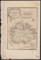
"No. 67" in lower left corner., Bar scale given in Enlgish miles., Cross Collection no. 295., From Bowen's A complete system of geography ... London : Printed for W. Innys, R. Ware ..., 1747., Has descriptive notes and ornamental cartouche., Imperfect: wormhole, with no loss of text. Hand col., and With paper tab pasted to left margin.
Publisher:
Printed for W. Innys, R. Ware ...,
Subject (Geographic):
Antigua--Maps--Early works to 1800
Subject (Name):
Bowen, Emanuel, d. 1767. A complete system of geography
A complete atlas, or distinct view of the known world., A new & accurate map of the islands of Newfoundland, Cape Breton, St. John and Anticosta., Newfoundland, Cape Breton, St. John and Anticosta [cartographic material], and The islands of Newfoundland, Cape Br
Description:
"No. 63" -- in lower left corner., From the author's A complete atlas or distinct view of the known world. 1752., Hand col. Mounted on linen. Ms. no. on recto: 61. Stamp on verso: W. Redmond Cross., Prime meridian: London., and Relief shown pictorially.
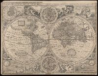
"Are to be sold in Pops- head Alle by Geor. Humble"., Cross collection no. 15., Double hemisphere, with smaller celestial hemispheres and astronomical diagram., From: A prospect of the most famous parts of the world... London...1627., Shows California as an island., and Text on verso: "The generall description of the world".
Publisher:
George Humble,
Subject (Name):
Humble, George, -1640. and Speed, John, 1552?-1629. Prospect of the most famous parts of the world.
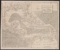
"For the London Magazine" appears above centre margin., Cross Collection no. 254., From The London magazine, v. 31, 1762, opp. p. 464., and Mounted on linen.
Publisher:
London Magazine,
Subject (Geographic):
Caribbean Area--Maps--Early works to 1800 and West Indies--Maps--Early works to 1800