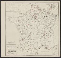
Coast charts nos. 11, 12 & 13, Coast of the United States, Monomoy and Nantucket Shoals to Block Island, Coast of the United States, Monomoy and Nantucket Shoals to Block Island ; Chart no. 11, and Monomoy and Nantucket Shoals to Muskeget Channel , Mass
Description:
"No. 111"--Upper left margin. and Includes text of sailing directions and dangers, buoys, bottoms, light houses and beacons, light vessels, variations of magnetic needle, tides, and two views.
Coast charts nos. 11, 12 & 13, Coast of the United States, Monomoy and Nantucket Shoals to Block Island, Coast of the United States, Monomoy and Nantucket Shoals to Block Island ; Chart no. 12, and Muskeget Channel to Buzzards Bay and entrance to Vineyard Sound
Description:
"No. 112"--Upper left margin. and Includes 7 views: View off west entrance to Vineyard Sound, Cuttyhunk Light ; View off west entrance to Vineyard Sound, Gay Head Light ; View off south entrance to Quicks Hole ... Fairhave spire ; West Chop Light bearing sout
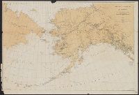
Also shows "reindeer country" in Eastern Siberia & steamboat lines., Date below subtitle: 1897., In lower right margin: S Doc 30 55 2., and Relief shown by hachures and spot heights.
Publisher:
s.n.,
Subject (Geographic):
Alaska--Maps
Subject (Name):
Jackson, Sheldon, 1834-1909 and Norris Peters Co
Subject (Topic):
Caribou--Alaska--Maps and Reindeer--Russia (Federation)--Siberia, Eastern--Maps
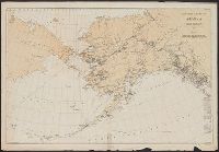
Also shows "reindeer country" in Eastern Siberia., In lower right margin: S Doc 70 57 2., Includes distance table., Library's copy annotated in red ink to indicate Episcopal missions., and Relief shown by hachures and spot heights.
Publisher:
s.n.],
Subject (Geographic):
Alaska--Maps
Subject (Name):
Jackson, Sheldon, 1834-1909
Subject (Topic):
Caribou--Alaska--Maps and Reindeer--Russia (Federation)--Siberia, Eastern--Maps
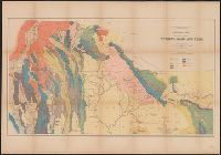
"Third annual report Reclamation Service, Pl. XXXI.", Relief shown by hachures and spot heights., and Shows irrigable lands, surveyed canal lines, and irrigation canals under construction.
Publisher:
U.S. G.P.O,
Subject (Name):
A. Hoen & Co and Geological Survey (U.S.). Reclamation Service. Annual report of the Reclamation Service
Subject (Topic):
Irrigation projects--Carson River Watershed (Nev.)--Maps, Irrigation projects--Truckee River Watershed (Calif. and Nev.)--Maps, and Irrigation--Nevada--Maps
"No. 1." in upper right margin., "To accompany report by Rear Admiral C.H. Davis, U.S.N., ordered by resolution of the Senate of the United States of March 19, 1866.", Copy 2 Imperfect. Mutilated with loss of text., and Relief shown by hachures.
"No. 1." in upper right margin., "To accompany report by Rear Admiral C.H. Davis, U.S.N., ordered by resolution of the Senate of the United States of March 19, 1866.", and Relief shown by hachures.
Geological and Geographical Survey of the Territories (U.S.)
Published / Created:
[1878?]
Call Number:
833ca 1878C
Container / Volume:
BRBL_00585
Image Count:
1
Resource Type:
Maps, Atlases & Globes
Description:
Relief shown by spot heights. and To accompany the Survey's 12th annual report (1878).
Publisher:
Julius Bien, Lith., and The Survey] ;
Subject (Name):
Endlich, F. M. (Frederick Miller), 1851-1899, Hayden, F. V. (Ferdinand Vandeveer), 1829-1887, Peale, A. C. (Albert Charles), 1849-1914, and St. John, O. H. (Orestes Henry)
Subject (Topic):
Geology--Idaho--Maps, Geology--Utah--Maps, and Geology--Wyoming--Maps