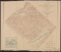
In lower left margin: The Edinburgh Geographical Institute., In lower right margin: John Bartholomew & Co., and Relief shown by contours, gradient tints, and spot heights.
Publisher:
National Geographic Society,
Subject (Geographic):
Mexico--Maps
Subject (Name):
Edinburgh Geographical Institute, Grosvenor, Gilbert Hovey, 1875-1966, John Bartholomew & Co, and National Geographic Society (U.S.)
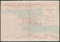
Series B, Wind and current charts, Wind and current chart, Wind and current chart, trade wind chart of the Atlantic Ocean, Wind and current charts, Wind and current charts, trade wind chart of the Atlantic Ocean, and Wind and current charts.
Description:
"Lith. of J. Bien. 180 Broadway. N.Y." and The trade wind charts were released as series B of Maury's "Wind and current charts", series A-F. Two sheets were produced, one for the Atlantic and the other for the Indian Ocean. For complete discussion, see "The w
Publisher:
s.n.],
Subject (Geographic):
Atlantic Ocean--Maps
Subject (Name):
Dehaven, E. J, Maury, Matthew Fontaine, 1802-1873. Wind and current charts, and United States. Bureau of Ordnance and Hydrography
Subject (Topic):
Nautical charts--Atlantic Ocean, Trade winds--Atlantic Ocean--Maps, and Winds--Atlantic Ocean--Maps
[Maury map collection ; ser. B1], Atlantic Ocean, and Wind and current charts
Description:
The trade wind charts were released as series B a part of Maury's "Wind and current charts", series A-F. Two sheets were produced, one for the Atlantic and the other for the Indian Ocean. For complete discussion, see "The wind and current chart series pro
Publisher:
United States Hydrographical Office],
Subject (Geographic):
Atlantic Ocean--Charts, diagrams, etc
Subject (Name):
Dehaven, E. J, Maury, Matthew Fontaine, 1806-1873. Wind and current charts, Morris, Charles, 1784-1856, United States Naval Observatory, United States. Bureau of Ordnance and Hydrography, and United States. Hydrographic Office
"Office of Economic Warfare, Cartographic section, Map information unit"--Stamped in the lower right margin., In lower left corner: No. 786, GDSS., Includes distances between destinations and inset map of Corsica., and Title supplied by cataloger.