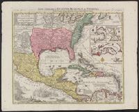
BEIN 85 1740D: Stamp on verso: Yale, Horace Brown, 1900S., BEIN 71 1737A: Forms part of the Benjamin Franklin Collection., Relief shown pictorially., "Cum gratia et privil S.R.I. Vicariatus in partibus Rheni Suevice et Juris Franconici.", Dates inferred from Portobelo inset showing "Admiralis Vernon Bachiam intrans d. 21 Novembr 1739" and reference in Lowery 328 to this map appearing as "... no. 190 in the 'Verlagsübersicht bis 1760', reprinted in Sandler's notice of Seutter.", and Includes insets of Portobelo, Havana, Cartagena, and Veracruz, text, and illustrations.
Publisher:
Tobias Conrad Seutter
Subject (Geographic):
North America, United States, Mexico, Central America, and Caribbean Area
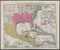
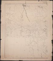
United States. War Department. Corps of Engineers, cartographer, publisher
Published / Created:
[1881]
Call Number:
831 1881A
Image Count:
2
Resource Type:
cartographic image
Description:
Relief shown by hachures., Scale "1 inch - 12 miles.", Shows battle sites and military expeditions, with dates., Westernmost sheet: "2nd edition May 1875 compiled under direction of Capt. Wm. Ludlow, Corps of Engrs."--Lower left margin., and In upper left margin: Brig. Genl. A.A. Humphreys, Chief of Engineers.
United States. War Department. Corps of Engineers, cartographer, publisher
Published / Created:
[1875?]
Call Number:
831 1875
Image Count:
1
Resource Type:
cartographic image
Description:
BEIN 831 1875: Imperfect: eastern sheet wanting; western sheet chipped. Inscription below edition statement: Lieut. [?] F. Eng., 5th Infty. Inscription on verso: Capt. Ludlow's map, 1875, sheet no. 1., Relief shown by hachures., Scale "1 inch - 12 miles.", Shows battle sites and military expeditions, with dates., and In upper left margin: Brig. Genl. A.A. Humphreys, Chief of Engineers.
Relief shown pictorially., North oriented down., Bar scale given in unidenified units., Coordinates not present on map and are approximated., Includes index of colleges, buildings, and streets., and Insets: view of Oxforde and a map of Oxfordshire with bar scale in miles.
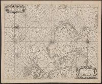
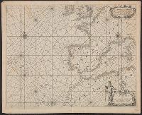
BEIN 21 1670A: Manuscript number on verso: 173. Watermark., Depths shown by isolines and soundings., Coordinates not present on map and are approximated., and From Blaeu's De groote Zee-spiegel (Amsterdam, 1655).
BEIN 21 1670B: Manuscript number on verso: 174. Watermark., Depths shown by isolines and soundings., Coordinates not present on map and are approximated., and From Blaeu's De groote Zee-spiegel (Amsterdam, 1655).
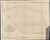
BEIN BrSides Folio 2014 10: Imperfect: torn and mutilated, with lower right corner missing., "Area 18 acres.", and Removed from: History of the city burial ground, in New Haven, together with the names of the owners of the lots therein (1863).
Publisher:
publisher not identified and Lith. by Punderson & Crisand
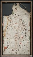
BEIN Art Storage 49cea 1425: Imperfect: lower left corner and bottom edge torn, with some loss of map; slight holes throughout. With leather thone tie on left edge., Portolan chart with seaport names given for all coastlines., Title devised by cataloger., Pen-and-ink in black, red, blue and green., Constantinople shown still in Christian possession; Thrace in possession of the Turks., Contains two compass roses., and Decoration: city views with banners.
Title supplied by cataloger., Nineteenth century forgery of a portlan chart., Manuscript note in accompanying case: A manuscript portolan on vellum probably executed by a Spanish chartmaker circa 1550, the coasts outlined in green with place names in gothic letters of red and black, decorated with devices of the sun and moon in umber heightened with gold, 14 x 9 inches. This chart is a rare example from its unusally small size. RH. 7487., and Pen and ink wash color on parchment, in Italian, in unidentified hand.