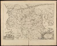
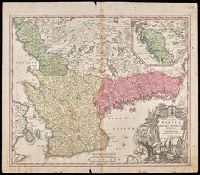
Relief shown pictorially., Verso blank., and Watermark. Manuscript number in upper left corner: 27. Manuscript annotations below neat line.
Publisher:
[Jan Jansson],
Subject (Geographic):
Albania, Albania--Maps--Early works to 1800., Europe--Macedonia, Greece--Maps--Early works to 1800., Macedonia (Republic)--Maps--Early works to 1800., and Macedonia--Maps--Early works to 1800.
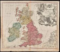
"Cum privilegio S.C.M.", Appeared in Homann's Atlas Novus Terrarum., Prime meridian: Ferro., Relief shown pictorially., Variant with portrait of George I in armour in the cartouche, Plymouth, England spelled correctly, and Delft, Netherlands misspelled "Dolft.", and Watermark. Manuscript number in upper right corner. From the Karpinski-von Wieser Map Collection.
Publisher:
[Johann Baptist Homann]
Subject (Geographic):
British Isles--Maps--Early works to 1800. and Europe--British Isles
Subject (Name):
Homann Erben (Firm) and Homann, Johann Baptist, 1663-1724. Atlas novus terrarum
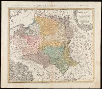
"La couleure violette marque les pays démembrés de la Pologne en 1772, conformément aux prétensions des trois Puissances voisines."--Lower left margin., Includes coat-of-arms, and 3 bar scales., Map in Latin; alternate title and legend in French., Prime meridian: Paris., Relief shown pictorially., and Watermark. Manuscript number in upper right corner. From the Karpinski-von Wieser Map Collection.
Publisher:
Luci publicae tradita per Homannianos Heredes
Subject (Geographic):
Belarus--Maps--Early works to 1800., Lithuania--Maps--Early works to 1800., Poland--Maps--Early works to 1800., and Ukraine--Maps--Early works to 1800.
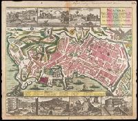
Includes index., Manuscript number in upper right corner: 63. Manuscript annotation in German at top. From the Karpinski-von Wieser Map Collection., Relief shown by shading and pictorially., and Views above upper and lower margins: Veduta del Molo -- Veduta di Castel del Ovo -- Veduta di Castel Nuovo -- Piazza del Mercato -- Veduta del l'Argo del Castello S. Elmo -- Vesuvius (with notes and inset profile of "Montis interioris conspectus") -- Veduta del Palazzo del Vice Re.
Publisher:
[Matthaeus Seutter]
Subject (Geographic):
Italy--Naples, Naples (Italy)--Aerial views--Early works to 1800., and Naples (Italy)--Maps--Early works to 1800.
"Cum Privilegio Sac. Caes. Maj.", Inset in upper right margin shows continuation of Halland., Relief shown pictorially., and Watermark. Manuscript number in upper right corner. Manuscript waste pasted to verso. From the Karpinski-von Wieser Map Collection.
Publisher:
[Johann Baptist Homann]
Subject (Geographic):
Blekinge län (Sweden)--Maps--Early works to 1800., Hallands län (Sweden)--Maps--Early works to 1800., Skåne (Sweden)--Maps--Early works to 1800., Sweden--Blekinge län, Sweden--Hallands län, and Sweden--Ma
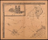
Grand plan de Paris et de ses environs, Paris et ses environs., Réproductions d'anciens plans de Paris, and Réproductions d'anciens plans de Paris ; [7].
Description:
"En vente, chez le sieur de Richesource, en place Daufine, à la Renomé. Publiée en 9 feuilles, accompagné d'une notice de M.A. Bonnardot"--Cover., "Gravé par François de La Pointe.", Accompanied by text: Grand plan de Jouvin de Rochefort, publié vers 1690 : extrait des Etudes archéologiques sur les anciens plans de Paris / Alfred Bonnardot., Cover title., Facsimile., Includes text: Grand plan de Jouvin de Rochefort, retouché en 1714 : extrait des Etudes archéologiques sur les anciens plans de Paris / Alfred Bonnardot., Includes view "Nostre Dame"., Inset map: Paris et ses environs., and Original scale information: "seize cens pas communs" ; "deux lieues communes de France"
Publisher:
A. Taride,
Subject (Geographic):
France--Paris, France--Paris Region, Paris (France)--Maps--Early works to 1800--Facsimiles., and Paris Region (France)--Maps.
Subject (Name):
Bonnardot, A. (Alfred). Grand plan de Jouvin de Rochefort., Cartes Taride (Firm), and La Pointe, François de.
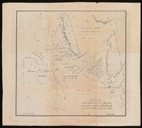
Coordinates not present on map and are approximated., Map of Champion Bay region (now Geraldton) in Western Australia, showing coastal soundings and topography of an area of approx. 250 square miles inland and south to Wizard Peak, centring on Mt. Fairfax. Shows Captain Grey's track and Captain Stokes' track. Relief shown by hachures and spot heights. Depths by soundings., and Originally published in: Discoveries in Australia : with an account of the coasts and rivers explored and surveyed during the voyage of H.M.S. Beagle in the years 1837-43 ... Volume 2 / J. Lort Stokes.
Publisher:
J. Arrowsmith,
Subject (Geographic):
Champion Bay (W.A.)--Maps., Geraldton Region (W.A.)--Discovery and exploration--Maps., and Western Australia--Geraldton Region
Subject (Name):
Beagle (Ship), Grey, George,--1812-1898, Grey, George,--1812-1898--Travel--Australia--Western Australia--Maps., Stokes, John Lort, 1811-1885. Discoveries in Australia., and Stokes, John Lort,--1811-1885--Travel--Australia--Western Australia--Maps.
Subject (Topic):
Discoveries in geography, Nautical charts--Australia--Champion Bay (W.A.), and Voyages and travels
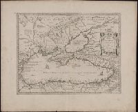
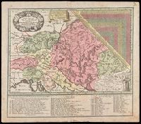
"Cum gratia et privil. S.R.I. Vicariatus, in partib[us] Rheni, Suevice, et Juris Franconici.", Covers Austria, Slovakia, Hungary, Transylvania, Slovenia and Croatia., Includes also ists of Jesuits active in the Austrian Empire., Includes table of distances given in hours of travel between individual locations., Manuscript number in upper right corner: 12. From the Karpinski-von Wieser Map Collection., and Relief shown pictorially.
Publisher:
M. Seutter
Subject (Geographic):
Europe, Central--Maps--Early works to 1800
Subject (Name):
Jesuits--Europe, Central--Maps--Early works to 1800 and Mayr, Johann Baptist, 1634-1708
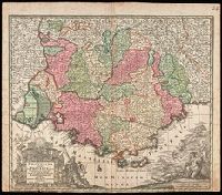
"Cum Gratia et Privil. S.R.I. Vicariatus in partibus Rheni, Sveviae et juris Franconici.", Ornamental cartouche decorated with coats of arms and mythical figures., Relief shown pictorially., and Watermark. Manuscript number in right corner: 24. From the Karpinski-von Wieser Map Collection.
Publisher:
[Mattheus Seutter]
Subject (Geographic):
France--Provence-Alpes-Côte d'Azur, Provence-Alpes-Côte d'Azur (France)--Administrative and political divisions--Maps--Early works to 1800., and Provence-Alpes-Côte d'Azur (France)--Maps--Early works to 1800.