Skip to search
Skip to main content
Skip to first result
Search
You Searched For
Genre
Maps
New Search
Search Results
Creator:
Published / Created:
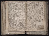
[ca. 1638]
Call Number:
1983 Folio 19
Collection Title:
[Atlas factice of 96 maps by Blaeu, Visscher, Jansson, Hondius and others]
Image Count:
1
Description:
Imperfect: torn and mutilated along fold, with some loss of text; edges reinforced with ms. waste. Sheet measures 41.5 x 51.3 cm. No. 74 of 92 maps bound together. and Numbered 80 [75, cancelled] on verso.
Publisher:
Hendrik Hondius
Subject (Geographic):
Thuringia (Germany) --Maps --Early works to 1800
Collection Created:
[1556-1680]
Found in:
Beinecke Rare Book and Manuscript Library > Thuringia lantgraviatus
Published / Created:
[1660?]
Call Number:
369 1660
Container / Volume:
BRBL_00146
Image Count:
2
Resource Type:
Maps, Atlases & Globes
Description:
Verso: Text.
Publisher:
Johannes Janssonius Exud.,
Subject (Geographic):
Thuringia (Germany)--Maps--Early works to 1800
Found in:
Beinecke Rare Book and Manuscript Library > Thuringiae Nova descriptio.
Published / Created:
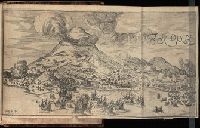
1603
Call Number:
E460 H879 1602 1
Collection Title:
Sechste Theil, Kurtze, warhafftige Relation vnd Beschreibung der wunderbarsten vier Schiffarten, so
Image Count:
1
Publisher:
impensis Collectoris
Collection Created:
Noribergae : impensis Collectoris, 1603
Found in:
Beinecke Rare Book and Manuscript Library > Tidore
Creator:
Published / Created:
1945
Call Number:
2726gmb 1945
Container / Volume:
BRBL_00023B
Image Count:
1
Resource Type:
Maps, Atlases & Globes
Alternative Title:
Its A.M.S. 9101 and Series (Standard map series designation system) ; 9101.
Description:
"Mercator projection.", Elevations shown by hachures and spot heights in meters., and Three classes of roads or trails are shown.
Publisher:
The Service,
Subject (Geographic):
Timor Island--Maps
Subject (Topic):
Transportation--Timor Island--Maps
Found in:
Beinecke Rare Book and Manuscript Library > Timor, special strategic map.
Creator:
Published / Created:
1942
Call Number:
68 T54 1942
Container / Volume:
BRBL_00350
Image Count:
1
Resource Type:
Maps, Atlases & Globes
Alternative Title:
Geographical Section, General Staff ; 4275 and GSGS (Series) ; 4275.
Description:
In upper margin: Algeria ... and Military grid.
Publisher:
Army Map Service, U. S. Army,
Subject (Geographic):
Tlemcen (Algeria)--Maps
Found in:
Beinecke Rare Book and Manuscript Library > Tlemcen.
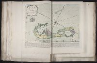
Creator:
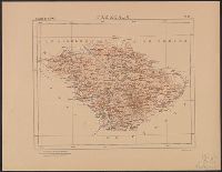
Published / Created:
1738?
Call Number:
2003 Folio 85
Image Count:
1
Description:
BEIN 2003 Folio 85: No. 33 of 45 maps bound together with binder's spine title: Atlas of America; ms. table of contents. Bookplate: Robinson. Bookplate of Paul Mellon., C. Lempriere delin., W.H. Thoms, sculp. Price 2s., Hand colored., is humbly dedicated by C. Lempriere and W.H. Thoms, 1738., Relief shown pictorially., and Scale [ca. 1:64,000].
Subject (Geographic):
Bermuda Islands -- Maps -- Early works to 1800
Found in:
Beinecke Rare Book and Manuscript Library > To His Excellency Alured Popple, Esq., governour of Bermuda, or the Summer Islands, this map, from a new survey correcting ye dangerous errors in all ye charts of that place hitherto publish'd
Branch:v1.64.0 ,Deployed:2024-09-11T10:25:34-04:00