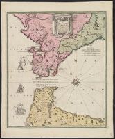
Carte nouvelle de l'Isle de Cadix & du Detroit de Gibraltar
Description:
"Avec privil. Caes.", Includes ill., Mounted on linen. Ms. no. on recto: 143. Stamp on verso: Karpinski-von Wieser Map Collection., and Relief shown pictorially. Depths shown by soundings.
Publisher:
Mr. Weidler ... aux depens des Heritiers du feu M. le Docteur Homann, geographe,
Subject (Geographic):
Andalusia (Spain)--Maps--Early works to 1800 and Gibraltar, Strait of--Maps--Early works to 1800
Subject (Name):
Homann Erben (Firm), Schneider, R. A, and Weidler, Johann Friedrich, 1691-1755
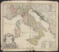
Gli stati d'Italia secondo le osservationi fatte dalla Societa di Se di Parigi, dal R.P. Riccioli della S. die Giesu ed. altri astronomi, di prima geograficamente delineati ... Sgr. de l'Isle ... alle spese degl' heredi d'Homann l'Anno MDCCXLII
Description:
Includes 14 bar scales., Relief shown pictorially., and Sheet measures 54.5 x 61.2 cm.
Publisher:
Curantibus Homannianis Heredibus,
Subject (Geographic):
Italy--Maps--Early works to 1800
Subject (Name):
L'Isle, Guillaume de, 1675-1726 and Riccioli, Giovanni Battista, 1598-1671
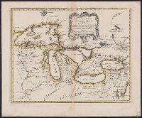
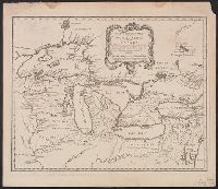
Covers the area from Lake Superior to Kaskaskia and from Delaware Bay to the Mississippi River., Relief shown pictorially., Shows a few towns, missions, forts, Indian villages and tribal territory, rivers and lakes, portages, and early place-names., and Watermark.
Publisher:
[Homann Erben?],
Subject (Geographic):
Canada--Maps--Early works to 1800., Great Lakes Region (North America)--Maps--Early works to 1800., and New France--Maps--Early works to 1800.
Covers the area from Lake Superior to Kaskaskia and from Delaware Bay to the Mississippi River., Relief shown pictorially., Shows a few towns, missions, forts, Indian villages and tribal territory, rivers and lakes, portages, and early place-names., and Watermark.
Publisher:
[Homann Erben?],
Subject (Geographic):
Canada--Maps--Early works to 1800, Great Lakes Region (North America)--Maps--Early works to 1800, and New France--Maps--Early works to 1800
Subject (Name):
Brown, Horace--Stamp, Homann Erben (Firm), and Thorne Collection of Cartogaphy and Geography Stamp
Copy 1: Borders of lakes and frame of map colored in yellow. Backed with linen. Stamp: Thorne Collection of Cartography and Geography. Stamp: Karpinski-von Wieser Map Collection., Covers the area from Lake Superior to Kaskaskia and from Delaware Bay to the Mississippi River., Relief shown pictorially., Shows a few towns, missions, forts, Indian villages and tribal territory, rivers and lakes, portages, and early place-names., and Watermark.
Publisher:
[Homann Erben?],
Subject (Geographic):
Canada--Maps--Early works to 1800, Great Lakes Region (North America)--Maps--Early works to 1800, and New France--Maps--Early works to 1800
Subject (Name):
Homann Erben (Firm) and Thorne Collection of Cartogaphy and Geography Stamp
Copy 2: Stamp: Yale Horace Brown 1900S. Manuscript note in unidentified hand., Covers the area from Lake Superior to Kaskaskia and from Delaware Bay to the Mississippi River., Relief shown pictorially., and Shows a few towns, missions, forts, Indian villages and tribal territory, rivers and lakes, portages, and early place-names.
Publisher:
[Homann Erben?],
Subject (Geographic):
Canada--Maps--Early works to 1800, Great Lakes Region (North America)--Maps--Early works to 1800, and New France--Maps--Early works to 1800
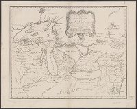
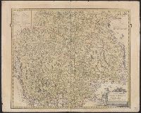
Bar scales given in "milliaria duo Germanica" and "milliaria Italica.", Hand colored. Stamp: Karpinski-von Wieser Map Collection. Manuscript notes in unidentified hand., Prime meridian: Ferro., and Relief shown pictorially.
Publisher:
Edentibus Homannianis Hered., C.P.S.C.M.,
Subject (Geographic):
Trentino-Alto Adige (Italy)--Maps--Early works to 1800 and Tyrol (Austria)--Maps--Early works to 1800