Skip to search
Skip to main content
Skip to first result
Search
You Searched For
Extent of Digitization
Completely digitized
Access
Public
Publication Place
New York :
New Search
Search Results
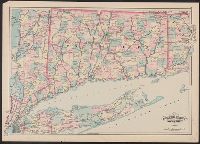
Published / Created:
1876
Call Number:
766 1876A
Container / Volume:
BRBL_00466
Image Count:
1
Resource Type:
Maps, Atlases & Globes
Publisher:
Asher & Adams ,
Subject (Geographic):
Connecticut--Maps
Found in:
Beinecke Rare Book and Manuscript Library > Asher & Adams' Connecticut
Published / Created:
1913
Call Number:
771ad N49 1913
Container / Volume:
BRBL_00493
Image Count:
6
Resource Type:
Maps, Atlases & Globes
Alternative Title:
Morris Park race track Bronx borough New York City
Publisher:
The Ohman Map Company,
Subject (Geographic):
Bronx (New York, N.Y.)--Maps
Found in:
Beinecke Rare Book and Manuscript Library > Auction sale of Morris Park race track Bronx borough New York City.
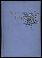
Creator:
Published / Created:
1893
Call Number:
JWJ Zan M433 893A
Image Count:
17
Publisher:
Press of J.J. Little & Co.,
Subject (Name):
Peterson, Jerome Bowers--Bookplate.--696 % sp13
Found in:
Beinecke Rare Book and Manuscript Library > Aunt Lindy : a story founded on real life / by Victoria Earle ; illustrated by Mary L. Payne.
Creator:
Published / Created:
[1914?]
Call Number:
11hcf 1919B-13
Container / Volume:
BRBL_00010O
Image Count:
3
Resource Type:
Maps, Atlases & Globes
Description:
Sheet 2 fragile, in 3 fragments.
Publisher:
American Geographical Society,
Subject (Geographic):
Austria--Maps and Europe, Eastern--Maps
Found in:
Beinecke Rare Book and Manuscript Library > Austria-Hungary [cartographic material].
Published / Created:
1908
Call Number:
763gmb 1908
Container / Volume:
BRBL_00452
Image Count:
1
Resource Type:
Maps, Atlases & Globes
Description:
"Geo. Walker & Co., Boston." in bottom right margin., Covers attached to verso. Not digitized., and Distances to cities written outside margins surrounding map.
Publisher:
Automobile Club of America ,
Subject (Geographic):
Vermont--Maps
Found in:
Beinecke Rare Book and Manuscript Library > Automobile map of Vermont, South.
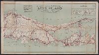
Published / Created:
1909
Call Number:
7715gmb 1909B
Image Count:
1
Resource Type:
Maps, Atlases & Globes
Description:
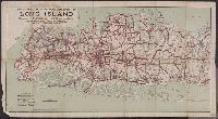
Copyright by the Automobile Club of America. and Includes insert map of the easternmost tip of Long Island.
Publisher:
Automobile Club of America,
Subject (Geographic):
Long Island (N.Y.)--Maps
Subject (Name):
Automobile Club of America and Bureau of Tours
Found in:
Beinecke Rare Book and Manuscript Library > Automobile map of eastern part of Long Island / compiled by Bureau of Tours and published by the Automobile Club of America.
Published / Created:
c1909.
Call Number:
7715gmb 1909A
Image Count:
1
Resource Type:
Maps, Atlases & Globes
Alternative Title:
Automobile map of western Long Island, N.Y.
Publisher:
Automobile Club of America,
Subject (Geographic):
Long Island (N.Y.)--Road maps
Subject (Name):
Automobile Club of America. Bureau of Tours
Found in:
Beinecke Rare Book and Manuscript Library > Automobile map of western part of Long Island / compiled by Bureau of Tours, Automobile Club of America.
Creator:
Published / Created:
[1914?]
Call Number:
44ak 1914A
Container / Volume:
BRBL_00256
Image Count:
1
Resource Type:
Maps, Atlases & Globes
Description:
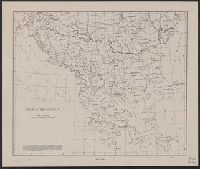
"Political boundaries as in July, 1914."
Publisher:
American Geographical Society,
Subject (Geographic):
Balkan Peninsula--Maps
Subject (Name):
American Geographical Society of New York
Found in:
Beinecke Rare Book and Manuscript Library > Balkan peninsula / drawn by Wm. Briesemeister.
Creator:
Published / Created:
[1918]
Call Number:
11hcf 1919C-2
Container / Volume:
BRBL_00010T
Image Count:
2
Resource Type:
Maps, Atlases & Globes
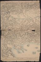
Description:
Relief shown by shading and spot heights.
Publisher:
The American Geographical Society,
Subject (Geographic):
Balkan Peninsula--Maps
Subject (Topic):
Slopes (Physical geography)--Balkan Peninsula--Maps
Found in:
Beinecke Rare Book and Manuscript Library > Block diagram showing terrain of the Balkan Peninsula.
Creator:
Published / Created:
1918
Call Number:
11hcf 1919E
Image Count:
1
Resource Type:
Maps, Atlases & Globes
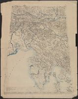
Description:
"Approximate scale in center of diagram 1:150,000, vertical exaggeration about 1 1/2 times.", 11hcf 1919E: Hand col. Sheet 1 with typed descriptive notes attached., and Relief shown by shading, land form drawing, hachures and spot heights.
Publisher:
American Geographical Society,
Subject (Geographic):
Friuli (Italy)--Maps, Istria (Croatia and Slovenia)--Maps, and Trieste Region (Italy)--Maps
Subject (Topic):
Block diagrams--Friuli (Italy : Province) and Block diagrams--Istria (Croatia and Slovenia)
Found in:
Beinecke Rare Book and Manuscript Library > Block diagram showing terrain of the Trieste-Isonzo region.
Branch:v1.61.6 ,Deployed:2024-06-12T09:55:19-04:00