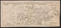
Imperfect: 2nd part of map wanting. Mounted on linen. Sheet measures 22.4 x 49.5 cm. Cross Collection no. 151., Prime meridian: London., pt. the first. Containing Canada, Nova scotia, Newfoundland, New England, part of New York, with the Lakes, Six Nations, and all the countries westward in the same parallels so far as discover'd; exhibiting the just boundaries, and the French encroachments: laid down from authentic surveys -- pt. the second. Containing part of New York, Pensilvania, New Jersey, Mary Land, Virginia, North & South Carolina, Georgia, Louisiana, and all the countries westward in the same parellels so far as discovered, shewing the course of the Rivers Ohio, Missisipi &c. exhibiting the just boundaries & the French encroachments laid down from authentic surveys., Relief shown pictorially., and Shows boundaries, rivers, forests, principal settlements and notes.
Publisher:
s.n.,
Subject (Geographic):
France--Colonies--America--Maps--Early works to 1800, Great Britain--Colonies--America--Maps--Early works to 1800, and North America--Maps--Early works to 1800