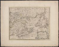
A new & accurate map of the Islands of Newfoundland, Cape Breton, St. John and Anticosta, Newfoundland, Cape Breton, St. John and Anticosta [cartographic material], and The Islands of Newfoundland, Cape Breton, St. John and Anticosta [cartographic material]
Description:
"No. 95" -- in lower right margin., Co, Hand col. Ms. note on verso: Appears as No. 63 in Bowen, E. Complete atlas, etc. London, 1752., London meridian., Relief shown pictorially., and Shows boundaries, rivers, forests, principal settlements and coastal landmarks.
Publisher:
s.n.,
Subject (Geographic):
Canada--Maps--Early works to 1800 and Maritime Provinces--Maps--Early works to 1800
A complete atlas, or distinct view of the known world., A new & accurate map of the islands of Newfoundland, Cape Breton, St. John and Anticosta., Newfoundland, Cape Breton, St. John and Anticosta [cartographic material], and The islands of Newfoundland, Cape Br
Description:
"No. 63" -- in lower left corner., From the author's A complete atlas or distinct view of the known world. 1752., Hand col. Mounted on linen. Ms. no. on recto: 61. Stamp on verso: W. Redmond Cross., Prime meridian: London., and Relief shown pictorially.
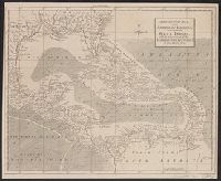
"For the London Magazine" appears above centre margin., Cross Collection no. 254., From The London magazine, v. 31, 1762, opp. p. 464., and Mounted on linen.
Publisher:
London Magazine,
Subject (Geographic):
Caribbean Area--Maps--Early works to 1800 and West Indies--Maps--Early works to 1800
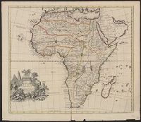
"For Mr. Postlethwayt's Universal dictionary of trade & commerce." and Includes ill., text, and inset of "A separate map of the Gold Coast upon a larger scale."
Publisher:
Printed for H. Woodfall [etc.],
Subject (Geographic):
Africa, West--Maps--Early works to 1800
Subject (Name):
Postlethwayt, Malachy, 1707?-1767. Universal dictionary of trade and commerce
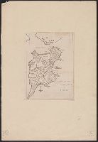
Gentleman's magazine (London, England) and Plan of the town of Boston
Description:
"Charles Town in ruins" is indicated in the northern part of the map., By Robert Aitken; no engraver's signature., From: The gentleman's magazine, v. 45, Oct. 1775., Relief shown pictorially., and Shows streets, wharves, fortifications, and The Common.
Publisher:
Gentleman's magazine,
Subject (Geographic):
Boston (Mass.)--Buildings, structures, etc.--Maps--Early works to 1800 and Boston (Mass.)--Maps--Early works to 1800
Subject (Topic):
Fortification--Massachusetts--Boston--Maps--Early works to 1800
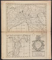
"Most humbly inscrib'd to ye most honoble. the Marquis of Annandale, kt. of the most noble & ancient Order of the Thistle.", Appears in the Senex's New general atlas. 1721., Includes ornamental cartouche., Prime meridian: London., and Relief shown pictorially.
" R. Spoffort Sc.", Appears in "A new sett of maps both of ancient and present geography"., Relief shown pictorially., and Shows boundaries, rivers, deserts, caravan routes, and principal settlements, with unexplored areas.
"Dedicated to His Highness William Duke of Glocester.", Appears in E. Wells' A new sett of maps both of antient and present geography., English, with Latin place names., Has watermark., Includes ornamental cartouche., and Relief shown pictorially.
Publisher:
s.n.,
Subject (Geographic):
Italy--Historical geography--Maps--Early works to 1800, Italy--History--To 476--Maps--Early works to 1800, and Rome--Maps--Early works to 1800
Subject (Name):
Nicholls, Sutton and Wells, Edward, 1667-1727. New sett of maps both of antient and present geography