From Jefferys's The American atlas ... London : Printed and sold by R. Sayer and J. Bennett, 1776., Hand col. Sheet measures 55.1 x 73.5 cm. Stamped no. on verso: 12. Cross Collection no. 160., and Relief shown pictorially. Depths shown by soundings.
Publisher:
By Thomas Jefferys, geographer to the King, printed for Robt. Sayer & Jno. Bennett,
Subject (Geographic):
Newfoundland, Island of (N.L.)--Maps--Early works to 1800
Subject (Name):
Cook, James, 1728-1779, Jefferys, Thomas, d. 1771. American atlas, Lane, Michael, fl. 1768-1784, and Robert Sayer and John Bennett (Firm)
Electorate of Brunswick-Luneburg with its dependencies
Description:
Imperfect: torn along fold, with some loss of text. Sheet measures 75.0 x 62.4 cm. No. 30 of 34 maps bound together., Inset map: Plan of the battle of Minden on the 1st of August 1759., Prime meridian: Ferro., and Relief shown pictorially.
Appears in Thomas Kitchin's General atlas describing the whole universe., Inc, Mounted on linen. Sheet measures 64.4 x 101 cm. Cross Collection no. 176., Relief shown pictorially. Soundings shown in fathoms., and With dedication to John Montagu, Earl of Sandwich.
Publisher:
Printed for Robt. Sayer, map & printseller,
Subject (Geographic):
Saint Lawrence River Valley--Maps--Early works to 1800 and Saint Lawrence River--Maps--Early works to 1800
Subject (Name):
Kitchin, Thomas, d. 1784. General atlas describing the whole universe and Sayer, Robert, 1725-1794
Subject (Topic):
Nautical charts--Saint Lawrence River--Early works to 1800
Appears in Thomas Kitchin's General atlas describing the whole universe., Includes text., and Insets: The Seven Islands -- A continuation of the river from Quebec to Lake Ontario -- St. Nicholas or English Harbor -- The mountains of our Lady or Notre Dame -- Th
Publisher:
Printed for Robt. Sayer, map & printseller,
Subject (Geographic):
Saint Lawrence River Valley--Maps--Early works to 1800 and Saint Lawrence River--Maps--Early works to 1800
Subject (Name):
Kitchin, Thomas, d. 1784. General atlas describing the whole universe and Sayer, Robert, 1725-1794
Subject (Topic):
Nautical charts--Saint Lawrence River--Early works to 1800
Hoüel, Jean-Pierre-Laurent, 1735-1813 Jefferys, Thomas, d. 1771
Published / Created:
[1768]
Call Number:
1977 Folio 177
Image Count:
2
Resource Type:
Maps, Atlases & Globes
Description:
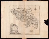
Bar scales given in "British miles 69 to a degree" and "British and French sea leagues 20 to a degree"., Imperfect: torn and mutilated on the right side, with no loss of text. Sheet measures 44.5 x 56.5 cm. No. 13 of 34 maps bound together., Prime meridian: Ferro., Relief shown by hachures; depths by soundings., Shows habitation or plantations, sugar works, oxen and water mills, observations points, etc., and Watermark.
"B.F. 10" in upper right corner., Cross Collection no. 315., From Jefferys's American atlas. London : R. Sayer and J. Bennett, 1776., Prime meridians: Ferro and London., Relief shown pictorially; depths by soundings., and Stamped no. on verso: 26.
Publisher:
Printed for Robt. Sayer ...,
Subject (Geographic):
Central America--Maps--Early works to 1800, Honduras, Gulf of--Maps--Early works to 1800, and Mexico, Southeast--Maps--Early works to 1800
Subject (Name):
Jefferys, Thomas, d. 1771. American atlas and Sayer, Robert, 1725-1794
Subject (Topic):
Nautical charts--Honduras, Gulf of--Early works to 1800
Peninsula and Gulf of Florida or Channel of Bahama with the Bahama Islands.
Description:
From Jefferys's The American atlas ... London : Printed and sold by R. Sayer and J. Bennett, 1776., Imperfect: detached along folds, with no loss of text. Sheets pasted together to form 1 sheet. Sheets measure 54 x 64 cm. and 54 x 66 cm., and Pictorial map.
Publisher:
Printed for Robt. Sayer, map and printseller ...,
Subject (Geographic):
Bahamas--Maps--Early works to 1800, Gulf Coast (Fla.)--Maps--Early works to 1800, and Gulf Coast (La.)--Maps--Early works to 1800
Subject (Name):
Jefferys, Thomas, d. 1771. American atlas and Sayer, Robert, 1725-1794
"This map is copied from an original drawn by Monsr. D'Anville ... & published at Paris in 1751. But since the Peace of 1762, that map has been supressed [sic] ... ", Includes descriptive notes,, Prime meridians: Ferro and London., and Relief shown pictorially.
Publisher:
Printed for Robert Sayer in Fleet Street & Thomas Jefferys in the Strand,
Subject (Geographic):
Africa, West--Maps--Early works to 1800, Coasts--Africa, West--Maps--Early works to 1800, and Gambia--Colonization--Maps--Early works to 1800
Subject (Name):
Anville, Jean Baptiste Bourguignon d', 1697-1782 and Sayer, Robert, 1725-1794
"This map is copied from an original drawn by Monsr. D'Anv, Also appeared in Kitchin's General atlas describing the whole universe. London : Printed for Robert Sayer, [1780]., Prime meridians: Ferro and London., and Relief shown pictorially; depths by soundings.
Publisher:
Printed for Robert Sayer,
Subject (Geographic):
Africa, West--Maps--Early works to 1800
Subject (Name):
Abbot, Charles,--Baron Colchester,--1757-1829--Bookplate, Anville, Jean Baptiste Bourguignon d', 1697-1782, Kitchin, Thomas, d. 1784. General atlas describing the whole universe, and Robert Laurie and James Whittle