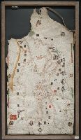
BEIN Art Storage 49cea 1425: Imperfect: lower left corner and bottom edge torn, with some loss of map; slight holes throughout. With leather thone tie on left edge., Portolan chart with seaport names given for all coastlines., Title devised by cataloger., Pen-and-ink in black, red, blue and green., Constantinople shown still in Christian possession; Thrace in possession of the Turks., Contains two compass roses., and Decoration: city views with banners.
Title supplied by cataloger., Nineteenth century forgery of a portlan chart., Manuscript note in accompanying case: A manuscript portolan on vellum probably executed by a Spanish chartmaker circa 1550, the coasts outlined in green with place names in gothic letters of red and black, decorated with devices of the sun and moon in umber heightened with gold, 14 x 9 inches. This chart is a rare example from its unusally small size. RH. 7487., and Pen and ink wash color on parchment, in Italian, in unidentified hand.
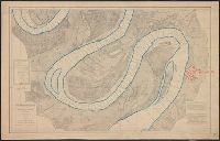
Backed with linen. River outline colored in blue; city of Greenville colored in red., Chart no. 39., Each sheet includes a list of authorities, note, and index chart.--Scale 1:360,000., Each sheet individually numbered, e.g.: Chart No.1, Chart No.2., Projected from a trigonometrical survey made in 1879-'80., and Relief shown by contours. Depths shown by soundings.
Publisher:
Mississippi River Commission,
Subject (Geographic):
Mississippi River and Mississippi River--Maps
Subject (Topic):
Nautical charts and Nautical charts--Mississippi River--Maps.
The West-India atlas: or, A compendious description of the West-Indies: illustrated with forty
Image Count:
1
Resource Type:
Maps, Atlases & Globes
Alternative Title:
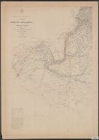
The harbours of Kingston and Port Royal and The windward passage, with the several passages, from the...east end of Cuba, and the north part of St. Domingo.
Description:
With two inset maps.
Subject (Geographic):
Cuba. and Santo Domingo (Dominican Republic)
Subject (Topic):
Nautical charts
Collection Created:
London, Printed for Robert Sayer and John Bennett, Fleet-Street, 1775
Maury's wind & current chart and Maury's wind and current chart
Description:
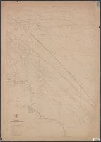
BEIN: 11cfk 1850A-4: Var. editions. 1 copy each of sheets 1-4 and sheets 5-8 mounted together on linen., Shows prevailing wind direction by month., Various eds. of some charts., Some sheets lack title and numberings., 1st and 2nd editions lack series designations A, B, C, etc., "The winds are denoted by small brushes, the head of the brush pointing to the direction whence the wind blows, the length of the brush shewing the comparative force.", "Eng. by Sherman & Smith N.Y."--Lower right margin on some sheets., "Series A.", Track chart, released as series A, a part of Maury's "Wind and current charts", series A-F. Covers the North Sea, the North Atlantic just west of the Hebrides, the Irish Sea, the English Channel, and the Bay of Biscay. The track charts were designed to illustrate the routes sailed by numerous Navy and merchant vessels. Directions of currents encountered and the force and direction of winds were included for each track. For complete discussion, see "The wind and current chart series produced by Matthew Fontaine Maury," by Marc I. Pinsel, in Navigation : Journal of the Institute of Navigation, v. 28, no. 2 (Summer, 1981), p. 123-137., Some sheets numbered individually in upper left margin, e.g.: 1, 2., On some sheets: Entered according to Act of Congress, in the year 1850, by M.F. Maury, in the Clerks office of the District Court of the southern district of New York., Accompanied by article from the magazine: Navigation : Journal of the Institute of Navigation. [16] leaves (p. 123-137) : photocopies ; 28 x 22 cm., Sheet no. 2 annotations in red ink., Copy imperfect: Sheets 1-2, 4 and torn and repaired along folid line. Sheet 2 covered in varnish. Sheets 1-3, 5-8 discoloration throughout, mounted on cloth backing., and Includes notes and printed track lines for numerous voyages of many different vessels on some sheets.
Publisher:
U.S. Hydrographical Office
Subject (Geographic):
North Atlantic Ocean. and North Atlantic Ocean
Subject (Topic):
Nautical charts, Winds, Ocean currents, Trade routes, Shipping, and Oceanography
Maury's wind & current chart and Maury's wind and current chart
Description:
BEIN: 11cfk 1850A-4: Var. editions. 1 copy each of sheets 1-4 and sheets 5-8 mounted together on linen., Shows prevailing wind direction by month., Various eds. of some charts., Some sheets lack title and numberings., 1st and 2nd editions lack series designations A, B, C, etc., "The winds are denoted by small brushes, the head of the brush pointing to the direction whence the wind blows, the length of the brush shewing the comparative force.", "Eng. by Sherman & Smith N.Y."--Lower right margin on some sheets., "Series A.", Track chart, released as series A, a part of Maury's "Wind and current charts", series A-F. Covers the North Sea, the North Atlantic just west of the Hebrides, the Irish Sea, the English Channel, and the Bay of Biscay. The track charts were designed to illustrate the routes sailed by numerous Navy and merchant vessels. Directions of currents encountered and the force and direction of winds were included for each track. For complete discussion, see "The wind and current chart series produced by Matthew Fontaine Maury," by Marc I. Pinsel, in Navigation : Journal of the Institute of Navigation, v. 28, no. 2 (Summer, 1981), p. 123-137., Some sheets numbered individually in upper left margin, e.g.: 1, 2., On some sheets: Entered according to Act of Congress, in the year 1850, by M.F. Maury, in the Clerks office of the District Court of the southern district of New York., Accompanied by article from the magazine: Navigation : Journal of the Institute of Navigation. [16] leaves (p. 123-137) : photocopies ; 28 x 22 cm., Sheet no. 2 annotations in red ink., Copy imperfect: Sheets 1-2, 4 and torn and repaired along folid line. Sheet 2 covered in varnish. Sheets 1-3, 5-8 discoloration throughout, mounted on cloth backing., and Includes notes and printed track lines for numerous voyages of many different vessels on some sheets.
Publisher:
U.S. Hydrographical Office
Subject (Geographic):
North Atlantic Ocean. and North Atlantic Ocean
Subject (Topic):
Nautical charts, Winds, Ocean currents, Trade routes, Shipping, and Oceanography