Skip to search
Skip to main content
Skip to first result
Search
You Searched For
Publication Place
Amstelodami
New Search
Search Results
Creator:
Published / Created:
[ca. 1696]
Call Number:
1973 Folio 10
Image Count:
1
Resource Type:
Maps, Atlases & Globes
Description:
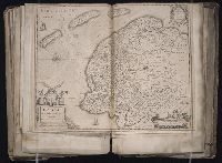
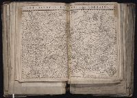
Bar scales in Milliaria Germanica Communia and Milliaria Gallica Communia., Ferro meridian., No. 37 of 69 maps bound together in composite atlas., Relief shown pictorially., and Scale [ca. 1:775 000].
Publisher:
[Frederik de Wit]
Subject (Geographic):
Prussia, east (Poland and Russia) --Maps --Early works to 1800
Found in:
Beinecke Rare Book and Manuscript Library > Ducatus Prussiae tam Polono Regiae quam Brandenburgo Ducalis : correcta descriptio et divisio Regiae scilicet in tres Palatinatus, et Ducalis in totidem circulos, cum utrius[que] subdivisione in tractus minores
Creator:
Published / Created:
[1631]
Call Number:
1983 Folio 19
Collection Title:
[Atlas factice of 96 maps by Blaeu, Visscher, Jansson, Hondius and others]
Image Count:
1
Description:
Numbered 63 on verso. and Reinforced along lower edges with manuscript waste. Sheet measures 38.8 x 51.3 cm. No. 59 of 92 maps bound together.
Publisher:
Henricus Hondius excudit
Subject (Geographic):
Friesland (Netherlands) --Maps --Early works to 1800
Collection Created:
[1556-1680]
Found in:
Beinecke Rare Book and Manuscript Library > Frisia occidentalis / auctoribus Adriano Metio et Gerardo Freitag
Creator:
Published / Created:
[ca. 1638?]
Call Number:
1983 Folio 19
Collection Title:
[Atlas factice of 96 maps by Blaeu, Visscher, Jansson, Hondius and others]
Image Count:
1
Description:
Sheet measures 40.8 x 52.3 cm. Reinforced along lower edges with manuscript waste. No. 42 of 92 maps bound together.
Publisher:
Apud Joannem Janssonium
Subject (Geographic):
Switzerland --Maps --Early works to 1800
Collection Created:
[1556-1680]
Found in:
Beinecke Rare Book and Manuscript Library > Helvetiae, Rhetiae & Valesiae cum omnibus finitimis regionibus tabula, vulgo Schweitzerland
Creator:
Published / Created:
[165-]
Call Number:
1983 Folio 19
Collection Title:
[Atlas factice of 96 maps by Blaeu, Visscher, Jansson, Hondius and others]
Image Count:
1
Description:
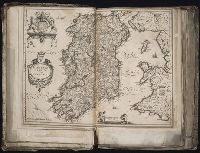
Imperfect: mutilated along fold, with no loss of text. Sheet measures 39 x 51 cm. No. 7 of 92 maps bound together.
Publisher:
Apud Joannem Janssonium
Subject (Geographic):
Ireland --Maps --Early works to 1800
Collection Created:
[1556-1680]
Found in:
Beinecke Rare Book and Manuscript Library > Hibernia regnum vulgo Ireland
Creator:
Published / Created:
anno 1636
Call Number:
1983 Folio 19
Collection Title:
[Atlas factice of 96 maps by Blaeu, Visscher, Jansson, Hondius and others]
Image Count:
1
Description:
Date in imprint has been altered to read "1656". Without watermarks. Reinforced along lower edges with manuscript waste. Sheet measures 39.4 x 50.3 cm. No. 60 of 92 maps bound together. and Numbered 65 on verso.
Publisher:
Apud Cornelio Dankero
Subject (Geographic):
Netherlands --Maps --Early works to 1800
Collection Created:
[1556-1680]
Found in:
Beinecke Rare Book and Manuscript Library > Hollandia comitatus
Creator:
Published / Created:
[1630?]
Call Number:
1983 Folio 19
Collection Title:
[Atlas factice of 96 maps by Blaeu, Visscher, Jansson, Hondius and others]
Image Count:
1
Description:
Sheet measures 39 x 51.5 cm. Reinforced along lower edges with manuscript waste. No. 41 of 92 maps bound together.
Publisher:
Apud Guiljelmum Blaeuw
Subject (Geographic):
Lorraine (France) --Maps --Early works to 1800
Collection Created:
[1556-1680]
Found in:
Beinecke Rare Book and Manuscript Library > Lotharingia Ducatus, vulgo Lorraine
Creator:
Published / Created:
[1700?]
Call Number:
1973 Folio 10
Image Count:
1
Resource Type:
Maps, Atlases & Globes
Description:
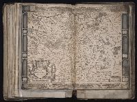
Ferro meridian., No. 51 of 69 maps bound together in composite atlas., Relief shown pictorially., and Scale [ca. 1:11 750 000].
Publisher:
[Frederik de Wit]
Subject (Geographic):
Asia --Maps --Early works to 1800
Found in:
Beinecke Rare Book and Manuscript Library > Magnae Tartariae : magni Mogolis imperii, Iaponiae et Chinae : nova descriptio ex tabula ampliss viri D.N. Witsen pro majori parte aliis auctoribus excerpta et dita
Creator:
Published / Created:
Anno 1705.
Call Number:
SSt3 705M
Image Count:
197
Description:
Without signatures.
Publisher:
Sumtibus auctoris, habitantis in de Kerk-Straat, tussen de Leydse- en Spiegel-Straat, ubi impressa & colorata prostant. Venduntur & apud Gerardum Valk op den Dam, in de Waakende Hond
Subject (Topic):
Insects
Found in:
Beinecke Rare Book and Manuscript Library > Metamorphosis insectorum Surinamensium : In qua erucæ ac vermes Surinamenses ... ad vivùm delineantur & describuntur ...
Published / Created:
1678
Call Number:
2004 +94
Collection Title:
Stephanos Peri poleon. Stephanus De urbibus. Quem primus Thomas de Pinedo Lusitanus Latii jure
Image Count:
1
Publisher:
typis Jacobi de Jonge
Collection Created:
Amstelodami, typis Jacobi de Jonge, 1678
Found in:
Beinecke Rare Book and Manuscript Library > Nil Moror Invidiam
Creator:
Published / Created:
[ca. 1630]
Call Number:
1983 Folio 19
Collection Title:
[Atlas factice of 96 maps by Blaeu, Visscher, Jansson, Hondius and others]
Image Count:
1
Description:
Imperfect: some ill. cut out or mutilated and replaced in ms.; torn along fold, with some loss of text. Sheet measures 41.3 x 57.5 cm. Reinforced along edges with printed waste. No. 87 of 92 maps bound together. and Numbered 93 on verso.
Publisher:
Ex officina et sumptibus Iudoci Hondii
Subject (Geographic):
Poland --Maps --Early works to 1800
Collection Created:
[1556-1680]
Found in:
Beinecke Rare Book and Manuscript Library > Nova Poloniae delineatio
Branch:v1.61.6 ,Deployed:2024-06-12T09:55:36-04:00