Skip to search
Skip to main content
Skip to first result
Search
You Searched For
Format
cartographic
Genre
Maps in books
New Search
Search Results
Published / Created:
Undated
Call Number:
1983 Folio 1
Collection Title:
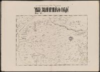
Chertezhnai'a' kniga Sibiri, sostavlennai'a' tobol'skim synom boi'a'rskim Semenom Remezovym v 1701
Image Count:
1
Resource Type:
Books, Journals & Pamphlets
Subject (Geographic):
China --Maps and Siberia (Russia) --Maps
Subject (Topic):
Great Wall of China (China)
Collection Created:
S.-Peterburg Izdano Arkheograficheskoi'u' kommisiei'u' izhdiveniem P.I. Likhacheva] 1882
Found in:
Beinecke Rare Book and Manuscript Library > [Map of southern Siberia]
Published / Created:
[1542]
Call Number:
Taylor 86
Collection Title:
Rvdimenta cosmographica
Image Count:
1
Subject (Geographic):
Balkan Peninsula and Greece
Subject (Topic):
Cosmography, Early maps, and Geography, Medieval
Collection Created:
Impressvm in inclyta Transylvaniae Corona 1542
Found in:
Beinecke Rare Book and Manuscript Library > [Map of the Balkan Peninsula including Macedonia and Greece]
Published / Created:
[1542]
Call Number:
Taylor 86
Collection Title:
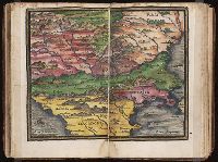
Rvdimenta cosmographica
Image Count:
1
Subject (Geographic):
Balkan Peninsula
Subject (Topic):
Cosmography, Early maps, and Geography, Medieval
Collection Created:
Impressvm in inclyta Transylvaniae Corona 1542
Found in:
Beinecke Rare Book and Manuscript Library > [Map of the Balkan Peninsula including Macedonia, Blugaria, Moldova]
Published / Created:
1918
Call Number:
2006 2031
Collection Title:
La beffa di Buccari : con aggiunti La canzone del Quarnaro, Il catalogo dei trenta di Buccari, Il
Image Count:
1
Description:
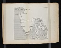
Bound in after p. 76 and Map of Buccari and Porto Re on verso
Subject (Geographic):
Istria (Croatia and Slovenia)
Subject (Topic):
World War, 1914-1918 --Territorial questions --Croatia --Rijeka
Collection Created:
Milano : Fratelli Treves, 1918
Found in:
Beinecke Rare Book and Manuscript Library > [Map of the Istrian penninsula (Croatia)]
Creator:
Call Number:
1974 +231
Collection Title:
A new and elegant general atlas, comprising all the new discoveries, to the present time
Image Count:
1
Description:
Map 57 from table of contents.
Subject (Geographic):
Louisiana Purchase--Pictorial works, Louisiana--Maps--1804, and North America--Maps
Collection Created:
Philadelphia, J. Conrad & co., Baltimore, M. & J. Conrad & co. [etc., etc.] 1804
Found in:
Beinecke Rare Book and Manuscript Library > [Map of the Louisiana Territory]
Call Number:
1974 +231
Collection Title:
A new and elegant general atlas, comprising all the new discoveries, to the present time
Image Count:
1
Description:
Map 37 from table of contents.
Subject (Geographic):
North America--Maps and United States--Maps--1804
Collection Created:
Philadelphia, J. Conrad & co., Baltimore, M. & J. Conrad & co. [etc., etc.] 1804
Found in:
Beinecke Rare Book and Manuscript Library > [Map of the United States of America]
Creator:
Published / Created:
1637
Call Number:
1983 Folio 19
Collection Title:
[Atlas factice of 96 maps by Blaeu, Visscher, Jansson, Hondius and others]
Image Count:
1
Description:
Imperfect: torn and mutilated along fold and edges, partially repaired, with some loss of text. Sheet measures 37.4 x 48.3 cm. No. 65 of 92 maps bound together. and Numbered 70 on verso.
Publisher:
[s.n.]
Subject (Geographic):
Valtellina (Italy) --Maps --Early works to 1800
Collection Created:
[1556-1680]
Found in:
Beinecke Rare Book and Manuscript Library > [Map of the Valtellina valley in northern Italy]
Published / Created:
[1509]
Call Number:
Taylor 46
Collection Title:
Cosmographia Pii Papae in Asiæ & Europæ eleganti descriptione : Asia. Historias rerum vbique
Image Count:
1
Description:
Map bound in before aaii
Subject (Topic):
Discoveries in geography and World maps --Early works to 1800
Collection Created:
[Paris]: Impressa ... per Henricum Stephanum impressorem dilige[n]tiss. Parrhisijs e regione scholae Decretorum. sumptib. eiusdem He[n]rici. & Ioa[n]nis Hongo[n]ti. VI. Idus Octobris anno Domini M.D.IX. [1509]
Found in:
Beinecke Rare Book and Manuscript Library > [Map of the world]
Published / Created:
1802
Call Number:
Im B388 Zz802B
Collection Title:
The imperial guide : with picturesque plans of the great post roads, containing miniatures
Image Count:
1
Description:
Bound in between p. 24-25. and William Beckford’s copy, with his penciled annotations. Autograph of William Beckford.
Subject (Geographic):
England --Guidebooks, England --Maps, Great Britain --Description and travel --Views, and Great Britain --Road maps
Subject (Topic):
Roads --Great Britain
Collection Created:
London : Printed by C. Whittingham, Dean Street, Fetter Lane, and sold by H.D. Symonds, Paternoster-Row; [etc], 1802
Found in:
Beinecke Rare Book and Manuscript Library > [Map: Carlisle to Bolton]
Published / Created:
1802
Call Number:
Im B388 Zz802B
Collection Title:
The imperial guide : with picturesque plans of the great post roads, containing miniatures
Image Count:
1
Description:
Bound in between p. 4-5. and William Beckford’s copy, with his penciled annotations. Autograph of William Beckford.
Subject (Geographic):
England --Guidebooks, England --Maps, Great Britain --Description and travel --Views, and Great Britain --Road maps
Subject (Topic):
Roads --Great Britain
Collection Created:
London : Printed by C. Whittingham, Dean Street, Fetter Lane, and sold by H.D. Symonds, Paternoster-Row; [etc], 1802
Found in:
Beinecke Rare Book and Manuscript Library > [Map: Coventry to Stony Stratford]
Branch:v1.61.8 ,Deployed:2024-06-20T11:15:04-04:00