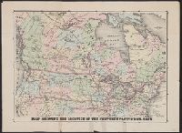
Shows proposed railroads primarily in the North Central United States and Canada; bullseye centering on Mackinaw City and the Great Lakes region and the Straits of Mackinaw connecting Lake Michigan and Lake Huron; Michigan counties, major cities and towns
Publisher:
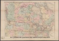
Middleton, Strobridge & Co.,
Subject (Geographic):
Canada--Maps, Great Lakes (North America)--Maps, and Middle West--Maps
Subject (Name):
Canadian Pacific Railway Company--Maps and Northern Pacific Railroad Company--Maps
Subject (Topic):
Counties--Michigan--Maps, Mines and mineral resources--Canada--Maps, Railroads--Canada--Maps, and Railroads--Great Lakes (North America)--Maps
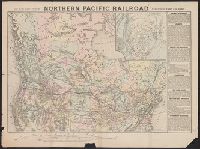
Map of the Northern Pacific Railroad, showing the intercontinental routes, oceanic currents and steamboat lines around the world. and Profiles of the Northern Pacific and the Central and Union Pacific Railroads, showing the difference in configuration of the
Description:
Date inferred from reference in text to lands " ... now ready for sale (January, 1872) ...." and Includes inset of "Map of the Northern Pacific Railroad, showing the intercontinental routes, oceanic currents and steamboat lines around the world," text, and "P
Map of the Northern Pacific Railroad, showing the intercontinental routes, oceanic currents and steamboat lines around the world. and Profiles of the Northern Pacific and the Central and Union Pacific Railroads, showing the difference in configuration of the
Description:
Includes inset of "Map of the Northern Pacific Railroad, showing the intercontinental routes, oceanic currents and steamboat lines around the world," text, and "Profiles of the Northern Pacific and the Central and Union Pacific Railroads, showing the diff
Publisher:
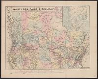
National Railway Publication Company, [187-?].
Subject (Name):
Northern Pacific Railroad Company--Maps
Subject (Topic):
Railroads--Canada--Maps and Railroads--United States--Maps