Search
You Searched For
Search Results
- Creator:
- Edward Stanford Ltd
- Published / Created:
- [1912?]
- Call Number:
- 96 1912
- Container / Volume:
- BRBL_00676
- Image Count:
- 1
- Resource Type:
- Maps, Atlases & Globes
- Found in:
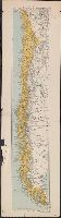
- Beinecke Rare Book and Manuscript Library > Chile.
- Creator:
- Edward Stanford Ltd
- Published / Created:
- 1919
- Call Number:
- 2732 1919
- Container / Volume:
- BRBL_00023B
- Image Count:
- 1
- Resource Type:
- Maps, Atlases & Globes
- Found in:
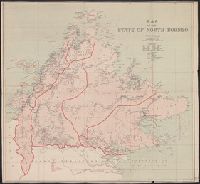
- Beinecke Rare Book and Manuscript Library > Map of the State of North Borneo, without hills.
- Creator:
- Edward Stanford Ltd
- Published / Created:
- August 1st, 1901.
- Call Number:
- 642 1901A
- Container / Volume:
- BRBL_00339
- Image Count:
- 1
- Resource Type:
- Maps, Atlases & Globes
- Found in:
- Beinecke Rare Book and Manuscript Library > Stanford's new map of the Orange River Colony, the southern part of the Transvaal, the northern frontier of Cape Colony, Natal, Basutoland, and Delagoa Bay in Portuguese East Africa / Stanford's Geographical Establishment, London.
- Creator:
- Edward Stanford Ltd
- Published / Created:
- 1903
- Call Number:
- 2732 1903
- Container / Volume:
- BRBL_00023B
- Image Count:
- 1
- Resource Type:
- Maps, Atlases & Globes
- Found in:
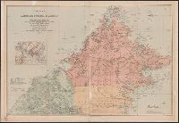
- Beinecke Rare Book and Manuscript Library > A map of British North Borneo / compiled from the English Admiralty charts and from the surveys and explorations of F.X. Witti, W.B. Pryer, F. Hatton, Henry Walker, D.D. Daly, and R.D. Beeston in the service of the British North Borneo Company.
- Creator:
- Edward Stanford Ltd
- Published / Created:
- 1913
- Call Number:
- 32 L84 1913A
- Container / Volume:
- BRBL_00051
- Image Count:
- 1
- Resource Type:
- Maps, Atlases & Globes
- Found in:
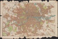
- Beinecke Rare Book and Manuscript Library > Stanford's new two inch map of London and its environs.
- Creator:
- Edward Stanford Ltd
- Published / Created:
- 1861
- Call Number:
- 75 1861G
- Container / Volume:
- BRBL_00402
- Image Count:
- 1
- Resource Type:
- Maps, Atlases & Globes
- Found in:
- Beinecke Rare Book and Manuscript Library > The United States of North America / constructed & engrd.at Stanford's Geographical Establishment.
- Creator:
- Edward Stanford Ltd
- Published / Created:
- [1917?]
- Call Number:
- 11hc 1917O
- Container / Volume:
- BRBL_00010E
- Image Count:
- 1
- Resource Type:
- Maps, Atlases & Globes
- Found in:
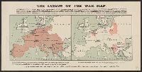
- Beinecke Rare Book and Manuscript Library > The lesson of the war map.
- Creator:
- Edward Stanford Ltd
- Published / Created:
- [1916?]
- Call Number:
- 30ed 1916
- Container / Volume:
- BRBL_00037B
- Image Count:
- 1
- Resource Type:
- Maps, Atlases & Globes
- Found in:
- Beinecke Rare Book and Manuscript Library > Subject nationalities of the German alliance.
- Creator:
- Edward Stanford Ltd
- Published / Created:
- 1917
- Call Number:
- 11hc 1917S
- Container / Volume:
- BRBL_00010E
- Image Count:
- 1
- Resource Type:
- Maps, Atlases & Globes
- Found in:
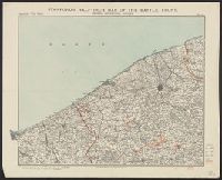
- Beinecke Rare Book and Manuscript Library > Stanford's half-inch map of the battle front, Ostend, Zeebrugge, Bruges / Edward Stanford Ltd.
- Creator:
- Edward Stanford Ltd
- Published / Created:
- 1917
- Call Number:
- 11hc 1917P
- Container / Volume:
- BRBL_00010E
- Image Count:
- 1
- Resource Type:
- Maps, Atlases & Globes
- Found in:
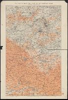
- Beinecke Rare Book and Manuscript Library > Stanford's half-inch map of the British front in France & Flanders.