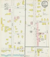
Sanborn fire insurance maps are a rich source of historic data on the urban built environment of North America during the 19th and early 20th centuries. The atlases were created for the purpose of underwriting fire insurance policies, which depended upon accurate and frequently-updated information about construction materials, municipal and transportation infrastructure, industrial and commercial landuse and more. The Yale University Library Map Department scanned its holdings of Sanborn fire insurance maps (consisting primarily of Connecticut towns) in order to make the maps more accessible.
Description:
"(8286).", Contains information on population, prevailing winds, water facilities and fire department., Partial cadastral map., and SMLMAPL 766 W22 1895: "Triplicate" stamp on sheet. Library of Congress copyright stamp on sheet.
Subject (Geographic):
East Windsor (Conn.)--Maps
Subject (Name):
Library of Congress Stamp
Subject (Topic):
Fire risk assessment--Connecticut--East Windsor--Maps and Real property--Connecticut--East Windsor--Maps
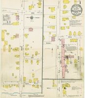
Sanborn fire insurance maps are a rich source of historic data on the urban built environment of North America during the 19th and early 20th centuries. The atlases were created for the purpose of underwriting fire insurance policies, which depended upon accurate and frequently-updated information about construction materials, municipal and transportation infrastructure, industrial and commercial landuse and more. The Yale University Library Map Department scanned its holdings of Sanborn fire insurance maps (consisting primarily of Connecticut towns) in order to make the maps more accessible.
Description:
"(4995.)", Contains information on population, prevailing winds, water facilities and fire department., Partial cadastral map., and SMLMAPL 766 W22 1901: "Triplicate" stamp on sheet. Library of Congress copyright stamp on sheet.
Subject (Geographic):
East Windsor (Conn.)--Maps
Subject (Name):
Library of Congress Stamp
Subject (Topic):
Fire risk assessment--Connecticut--East Windsor--Maps and Real property--Connecticut--East Windsor--Maps
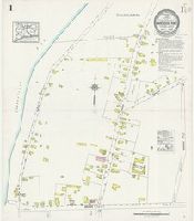
Sanborn fire insurance maps are a rich source of historic data on the urban built environment of North America during the 19th and early 20th centuries. The atlases were created for the purpose of underwriting fire insurance policies, which depended upon accurate and frequently-updated information about construction materials, municipal and transportation infrastructure, industrial and commercial landuse and more. The Yale University Library Map Department scanned its holdings of Sanborn fire insurance maps (consisting primarily of Connecticut towns) in order to make the maps more accessible.
Alternative Title:
July 1911, Warehouse Point Conn.
Description:
"3901 (2 sheets).", Contains information on population, prevailing winds, water facilities and fire department., Partial cadastral map., and SMLMAPL 766 W22 1911: Sheets disbound. "Triplicate" stamp on sheet. Library of Congress copyright stamp on title sheet.
Subject (Geographic):
East Windsor (Conn.)--Maps
Subject (Name):
Library of Congress Stamp
Subject (Topic):
Fire risk assessment--Connecticut--East Windsor--Maps and Real property--Connecticut--East Windsor--Maps
Sanborn fire insurance maps are a rich source of historic data on the urban built environment of North America during the 19th and early 20th centuries. The atlases were created for the purpose of underwriting fire insurance policies, which depended upon accurate and frequently-updated information about construction materials, municipal and transportation infrastructure, industrial and commercial landuse and more. The Yale University Library Map Department scanned its holdings of Sanborn fire insurance maps (consisting primarily of Connecticut towns) in order to make the maps more accessible.
Alternative Title:
July 1925, Warehouse Point Conn.
Description:
"(2387) 2 sheets.", Contains information on population, prevailing winds, water facilities and fire department., Includes inset map on title sheet showing location of town within state of Connecticut., Partial cadastral map., and SMLMAPL 766 W22 1925: Sheets disbound. "Triplicate" stamp on sheet. Library of Congress copyright stamp on title sheet.
Subject (Geographic):
East Windsor (Conn.)--Maps
Subject (Name):
Library of Congress Stamp
Subject (Topic):
Fire risk assessment--Connecticut--East Windsor--Maps and Real property--Connecticut--East Windsor--Maps
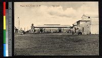
Accra Gold Coast W. A. Ware House. A large open yard is depicted with a brick warehouse visible on the far and right hand sides. A few men stand in the yard., Also included in the International Mission Photography Archive., and The back of the postcard has no handwriting. Printed at the edge of the correspondence section is "Copyright of Basel Mission Book depot, Accra, W.-Africa, No. 4."
Archives of the United Board for Christian Higher Education in Asia
Container / Volume:
Box 420 | Folder 5914
Image Count:
1
Resource Type:
Prints & Photographs
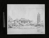
Description:
Also included in the International Mission Photography Archive., Warner Gymnasium - Yenching University - Peking Henry Killam Murphy Architect - New York City "Pagoda Water Tower." "Picture No. 14 is the Warner Memorial Gymnasium. Here the architect has very happily combined the beautiful architectural lines with the utility of a modern building. Not far away is the Porter Pagoda, which is a new way of treating a water tower (V). This idea makes it possible to have one of the most beautiful water towers in the world. Most water towers disfigure the landscape." Design drawing depicting the buildings., and Yenching University was later known as Yanjing da xue.