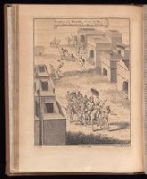
Compiled by John Green, but known as the Astley collection. and v. 3. Voyages and travels to Guinea, Benin, Kongo and Angola. Description of Loango, Kongo, Angola, Benguela, and adjacent countries. Description of the countries along the eastern coast of Africa, from Cape of Good Hope to Cape Guarda Fuy. Voyages and travels in China, 1655-1722.
Publisher:
Printed for T. Astley,
Subject (Geographic):
Benin--History--Early works to 1800
Subject (Topic):
Voyages and travels--Early works to 1800, Voyages and travels--History--18th century, and Voyages and travels--History--Sources
Pine, John, 1690-1756 Rocque, John, d. 1762 Tinney, John
Published / Created:
1746
Call Number:
2002 Folio 94
Image Count:
1
Resource Type:
Maps, Atlases & Globes
Alternative Title:
Contracted sketch of the plan of London &c. and Plan of the cities of London and Westminster and borough of Southwark.
Description:
"Published in October 1746 ... ", An index map to accompany Rocque's A plan of the cities of London and Westminster and borough of Southwark., Maps in volume are tab mounted., and Title from no. 1 of 7 works (comprising 45 maps) bound together in a vol. with hand-lettered dust jacket with ms. title, "Rocques map of London, 1746,"and autograph of Ralph Hodgson.
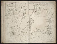
Atlas minor: or a set of sixty-two new and correct maps, of all parts of the world. All composed
Image Count:
1
Description:
Autograph of Gravely. Autograph of Baldock. Autograph of Aston. Autograph of W. Alington. and Teaching resource: Professor John Mack Faragher, History 141: The American West.
Subject (Geographic):
America--Maps--Early works to 1800 and Fundy, Bay of--Maps
A collection of voyages and travels, some now first printed from original manuscripts, others now
Image Count:
4
Description:
In: Churchill, Awnsham, d. 1728. Collection of voyages and travels. London : Printed by assignment from Messrs. Churchill, for H. Lintot [etc.], 1746 vol. 5.
Publisher:
Printed by assignment from Messrs. Churchill, for H. Lintot [etc.],
Subject (Geographic):
America--Discovery and exploration, Angola--Description and travel--Early works to 1800, Guinea--Description and travel--Early works to 1800, Guyana--Description and travel--Early works to 1800, and West Indies--Description and travel--Early works to 1800
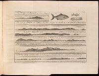
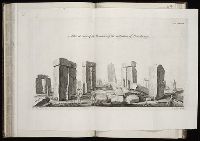
Album containing 122 engravings by Stukeley, many in proof, assembled by the artist himself. Contents include 85 engravings from Itinerarium Curiosum and 23 from Stonehenge, a Temple Restor’d to the British Druids.
Description:
Folio plate, tab bound. and Plate numbered 113.
Subject (Geographic):
Great Britain --Antiquities --Early works to 1800 and Wiltshire (England) --Antiquities
Subject (Topic):
Megalithic monuments --England --Wiltshire and Stonehenge (England)--Early works to 1800
Atlas minor: or a set of sixty-two new and correct maps, of all parts of the world. All composed
Image Count:
1
Resource Type:
Maps, Atlases & Globes
Description:
Autograph of Gravely. Autograph of Baldock. Autograph of Aston. Autograph of W. Alington. and Teaching resource: Professor John Mack Faragher, History 141: The American West.
Subject (Geographic):
America--Maps, Europe, Northern--Maps--Early works to 1800, Great Britain--Maps--Early works to 1800, and Ireland--Maps--Early works to 1800