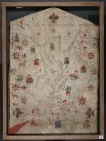
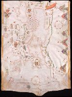
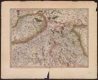
Contains eleven compass roses., Decoration: city views with banners, figures sitting on thrones, holding swords and armorial shields; animals; three fleur-de-lis., Imperfect: chipped along bottom edge, with some loss of map., Includes degrees of latitude along left edge: 25°N to 65°N., Pen-and-ink in black, red, blue and green., Portolan chart with seaport names given for all coastlines., and Title devised by cataloger.
Subject (Geographic):
Black Sea--Maps--Early works to 1800., Mediterranean Sea--Maps--Early works to 1800., and North Atlantic Ocean--Maps--Early works to 1800.
Subject (Topic):
Nautical charts--Black Sea--Early works to 1800., Nautical charts--Mediterranean Sea--Early works to 1800., and Nautical charts--North Atlantic Ocean--Early works to 1800.
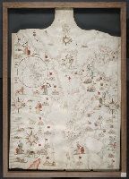
Contains five compass roses., Decoration: city views with banners, figures holding swords and armorial shields., Includes inset map of the world at lower left., Pen-and-ink in black, red, blue and green., Portolan chart with seaport names given for all coastlines., and Title devised by cataloger.
Subject (Geographic):
Black Sea--Maps--Early works to 1800., Mediterranean Sea--Maps--Early works to 1800., and North Atlantic Ocean--Maps--Early works to 1800.
Subject (Topic):
Nautical charts--Black Sea--Early works to 1800., Nautical charts--Mediterranean Sea--Early works to 1800., and Nautical charts--North Atlantic Ocean--Early works to 1800.
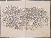
Cordiform projection., From: "Claudii Ptholemaei Alexandrini liber geographiae cum tabulis...", From: Clavdii Ptholemaei Alexandrini Liber geographiae cvm tabvlis...1511., Lanman collection; dgvmp2008., Map is printed in two colors, red and black., Outer map border shows decorative windheads and zodiacal signs., The author's name is often given as Bernard Sylvanus (see Shirley entry 32, plate 35) or Bernardus Sylvanus., and Title supplied by cataloger.
Publisher:
Per Iacobum Pentium de Leucho,
Subject (Name):
Pencio, Jacopo, active 1486-1530 and Ptolemy, active 2nd century. Geographia
Cordiform projection., From Claudii Ptholemaei Alexandrini Liber geographiae cum tabulis ... [Venice : Jacopo Pencio, 1511]., Lanman Collection; dgvmp2008., Left side of the map indicates climates; right side shows zodiacal signs., Map is known as the Bernardus Sylvanus world map., Map is printed in two colors, red and black., Silvani does not show any part of the new world on this map., The verso of the right part of map is showing the western part of the British Isles., and Title supplied by cataloger.
Publisher:
Jacopo Pencio,
Subject (Name):
Gastaldi, Giacomo, ca. 1500-ca. 1565, Pencio, Jacopo, fl. 1486-1530, and Ptolemy, active 2nd century. Geographia
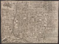
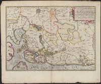
Appears in Mercator's Galliae tabula geographicae ... [Duisburg ca.1595]., Latin text on verso., Page number on verso "163-164"., Relief shown pictorially., Sheet measures 45.5 x 56.2 cm., and Title supplied by Koeman.
Publisher:
Gerardum Mercatorem,
Subject (Geographic):
Basel (Switzerland : Canton)--Maps--Early works to 1800, Switzerland--Maps--Early works to 1800, and Zurich (Switzerland : Canton)--Maps--Early works to 1800