Skip to search
Skip to main content
Skip to first result
Search
You Searched For
Resource Type
Maps, Atlases & Globes
Language
German
New Search
Search Results
Published / Created:
1940
Call Number:
7715cea 1940
Image Count:
1
Resource Type:
Maps, Atlases & Globes
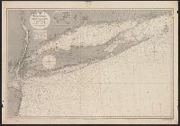
Description:
Wilhelmshaven submarine base stamp at top of chart.
Publisher:
Hydrokartogr. Anstalt von R. Enderick,
Subject (Geographic):
Long Island (N.Y.)--Maps
Found in:
Beinecke Rare Book and Manuscript Library > [German Chart No. 455] Atlantischer Ozean Ostküste von Nordamerika Block Island Bis New York.
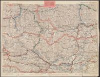
Published / Created:
1917
Call Number:
11hc 1918-Z22
Container / Volume:
BRBL_00010G
Image Count:
1
Resource Type:
Maps, Atlases & Globes
Alternative Title:
Jouy
Description:
"Bearbeitet und gedruckt von der Vermessungs-Abtielung im September 1917.", "Stand vom24.September 1917.", and "Stellungen bearbeitet und gedruckt von der Vermessungs-Abtlg. Kartenstelle Gruppe Vailly."
Publisher:
s.n.,
Subject (Geographic):
France--Maps
Found in:
Beinecke Rare Book and Manuscript Library > [Grabenkarte der 7. Armee. Bl.16. Jouy.]
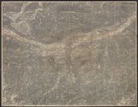
Published / Created:
1880?]
Call Number:
3627 G92 1880
Image Count:
2
Resource Type:
Maps, Atlases & Globes
Description:
Dissected and mounted on linen.
Publisher:
s.n,
Subject (Geographic):
Bavaria (Germany)--Maps
Found in:
Beinecke Rare Book and Manuscript Library > [Grünwald and Environs].
Published / Created:
[1780?]
Call Number:
36 H362 1780
Container / Volume:
BRBL_00124
Image Count:
1
Resource Type:
Maps, Atlases & Globes
Subject (Geographic):
Germany--Maps--Early works to 1800
Found in:
Beinecke Rare Book and Manuscript Library > [Heidelburg and Environs.]
Published / Created:
[1915?]
Call Number:
427gmb 1915
Container / Volume:
BRBL_00247
Image Count:
2
Resource Type:
Maps, Atlases & Globes
Publisher:
Ed. Hölzels geogr. Institut,
Subject (Geographic):
Carinthia (Austria)--Maps
Found in:
Beinecke Rare Book and Manuscript Library > [Hözels Automobilkarten]. Blatt XVII - Klagenfurt-Hofgastein.
Published / Created:
19--.
Call Number:
565 1905X
Container / Volume:
BRBL_00299
Image Count:
1
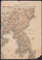
Resource Type:
Maps, Atlases & Globes
Description:
Section of map in German, showing Manchuria and Korean peninsula, with titular map areas outlined and labeled in green.
Publisher:
s.n.,
Subject (Geographic):
Manchuria (China)--Maps
Found in:
Beinecke Rare Book and Manuscript Library > [Index map for Campaign in Manchuria maps.]
Published / Created:
1875?]
Call Number:
428 IN7 1875
Container / Volume:
BRBL_00248
Image Count:
1
Resource Type:
Maps, Atlases & Globes
Publisher:
s.n.,
Subject (Geographic):
Tyrol (Austria)--Maps
Found in:
Beinecke Rare Book and Manuscript Library > [Innsbruck and Environs].
Published / Created:
[1878?]
Call Number:
428 IN7 1878
Container / Volume:
BRBL_00248
Image Count:
1
Resource Type:
Maps, Atlases & Globes
Description:
Borders of map in gold and red, illustrations of two buildings., In upper right corner of map: Neujahrs-Entschuldigung, 1879., and On panel: Plan von Innsbruck, 1878, R. Wieser.
Publisher:
Lit. C. Redlich,
Subject (Geographic):
Innsbruck (Austria)--Maps
Found in:
Beinecke Rare Book and Manuscript Library > [Innsbruck].
Published / Created:
1936?]
Call Number:
11hd 1942D-51
Container / Volume:
BRBL_00010ZD
Image Count:
1
Resource Type:
Maps, Atlases & Globes
Publisher:
s.n,
Subject (Geographic):
Germany--Maps and Poland--Maps
Found in:
Beinecke Rare Book and Manuscript Library > [Karte des Deutschen Reiche, Polen.]
Published / Created:
1945?]
Call Number:
11hd 1945G-3
Container / Volume:
BRBL_00010ZF
Image Count:
1
Resource Type:
Maps, Atlases & Globes
Description:
Ms. notes in German. and Titile supplied by cataloger.
Publisher:
s.n.,
Subject (Geographic):
Baden-Württemberg (Germany)--Maps
Found in:
Beinecke Rare Book and Manuscript Library > [Karte des Deutschen Reiches 1:100,000, Ulm and vicinity]
Branch:v1.61.8 ,Deployed:2024-06-20T11:14:46-04:00